Property Record
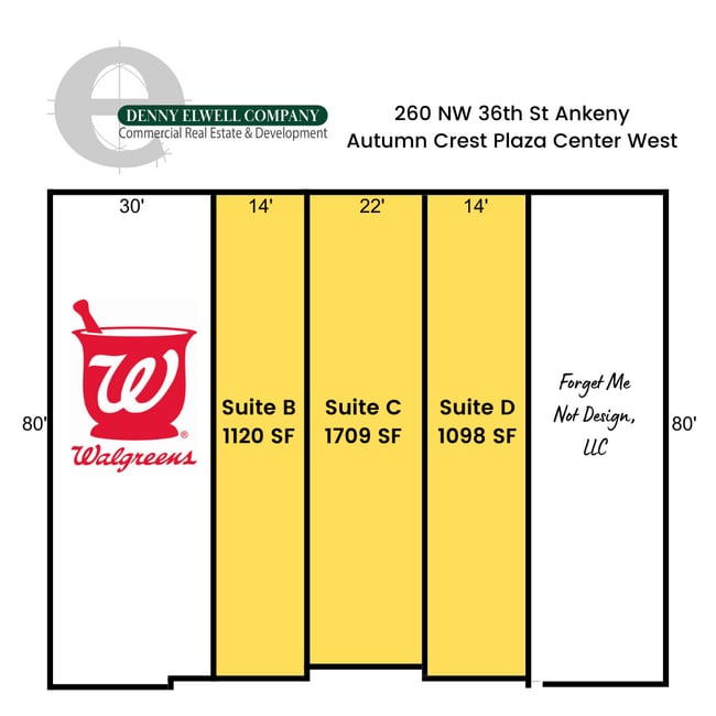
260 Nw 36Th St, Ankeny, IA 50023


NEARBY LISTINGS FOR SALE OR LEASE
Property Detail
260 Nw 36Th St
Des Moines
Autumn Crest Plat 6
Des Moines-West Des Moines, IA
LOT 1 -EX COM SW COR LOT 3 AUTUMN CREST PLAT 8 THN E 272.67F TO POB THN N 8.50F E 20F S 8.50F W 20F TO POB- AUTUMN CREST PLAT 6
181/00211-268-603
Polk
Regionalshoppingcenterormallwithanchorstore
Iowa
0
1,3
2025
1.15 AC
010216
Outlying Polk County
8,679 SF
DEMOGRAPHICS near 260 Nw 36Th St
1 Mile
3 Mile
5 Mile
2024 Total Population
8,801
49,547
78,480
2029 Population
9,197
52,013
82,526
Pop Growth 2024-2029
+ 4.50%
+ 4.98%
+ 5.16%
Average Age
36
37
36
2024 Total Households
3,584
19,642
30,397
HH Growth 2024-2029
+ 4.69%
+ 5.13%
+ 5.32%
Median Household Inc
$90,279
$89,349
$94,460
Avg Household Size
2.40
2.50
2.50
2024 Avg HH Vehicles
2.00
2.00
2.00
Median Home Value
$309,893
$276,447
$283,764
Median Year Built
2010
2003
2005
Nearby Places
Map Layers
Map Styles
 Street
 Aerial
- Restaurants
- Banks
- Shops
- Fitness
- Groceries
PUBLIC TRANSPORTATION
AIRPORT
Des Moines International
DRIVE
WALK
Distance
Des Moines International
36 min
17.9 mi
Freight Ports
Port Milwaukee
DRIVE
WALK
Distance
Port Milwaukee
424 min
378.3 mi
Nearby Properties
Address
Land Use
TOTAL SIZE
Lot Size
Zoning
Address
Land Use
TOTAL SIZE
Lot Size
Zoning
2,732,552 SF
443.35 AC
Address
Land Use
TOTAL SIZE
Lot Size
Zoning
519,216 SF
42.20 AC
Address
Land Use
TOTAL SIZE
Lot Size
Zoning
272,072 SF
11.70 AC
Address
Land Use
TOTAL SIZE
Lot Size
Zoning
210,696 SF
6.57 AC
Address
Land Use
TOTAL SIZE
Lot Size
Zoning
100,751 SF
12.67 AC
C-2
Address
Land Use
TOTAL SIZE
Lot Size
Zoning
48,839 SF
16.05 AC
Address
Land Use
TOTAL SIZE
Lot Size
Zoning
170,692 SF
6.54 AC
Address
Land Use
TOTAL SIZE
Lot Size
Zoning
63,664 SF
9.02 AC
Address
Land Use
TOTAL SIZE
Lot Size
Zoning
162,384 SF
11.16 AC
R-3
Address
Land Use
TOTAL SIZE
Lot Size
Zoning
144,992 SF
6.03 AC
Address
Land Use
TOTAL SIZE
Lot Size
Zoning
99,775 SF
11.26 AC
C-2
Address
Land Use
TOTAL SIZE
Lot Size
Zoning
73,392 SF
6.70 AC
Address
Land Use
TOTAL SIZE
Lot Size
Zoning
51,108 SF
17.81 AC
Address
Land Use
TOTAL SIZE
Lot Size
Zoning
113,394 SF
3.95 AC
Address
Land Use
TOTAL SIZE
Lot Size
Zoning
104,792 SF
8.25 AC
Address
Land Use
TOTAL SIZE
Lot Size
Zoning
98,020 SF
4.80 AC
Address
Land Use
TOTAL SIZE
Lot Size
Zoning
43,792 SF
12.50 AC
R1
Address
Land Use
TOTAL SIZE
Lot Size
Zoning
59,482 SF
5 AC
PUD
Address
Land Use
TOTAL SIZE
Lot Size
Zoning
114,024 SF
10.82 AC
Address
Land Use
TOTAL SIZE
Lot Size
Zoning
106,176 SF
4.35 AC
Address
Land Use
TOTAL SIZE
Lot Size
Zoning
78,758 SF
8.15 AC
Address
Land Use
TOTAL SIZE
Lot Size
Zoning
57,306 SF
9.13 AC
R-2
Address
Land Use
TOTAL SIZE
Lot Size
Zoning
82,405 SF
8.84 AC
R-2
Address
Land Use
TOTAL SIZE
Lot Size
Zoning
53,800 SF
5.17 AC
Address
Land Use
TOTAL SIZE
Lot Size
Zoning
70,456 SF
7.93 AC
C-2
Address
Land Use
TOTAL SIZE
Lot Size
Zoning
67,027 SF
6.02 AC
Address
Land Use
TOTAL SIZE
Lot Size
Zoning
134,168 SF
3.13 AC
Address
Land Use
TOTAL SIZE
Lot Size
Zoning
37,270 SF
21.47 AC
R-1
Address
Land Use
TOTAL SIZE
Lot Size
Zoning
128,744 SF
4.06 AC
Address
Land Use
TOTAL SIZE
Lot Size
Zoning
63,448 SF
3.39 AC
The World's #1 Commercial Real Estate Marketplace
Connect with us
© 2026 CoStar Group
The information above has been obtained from sources believed reliable. While we do not doubt its accuracy we have not verified it and make no guarantee, warranty or representation about it. It is your responsibility to independently confirm its accuracy and completeness. Any projections, opinions, assumptions, or estimates used are for example only and do not represent the current or future performance of the property. The value of this transaction to you depends on tax and other factors which should be evaluated by your tax, financial, and legal advisors. You and your advisors should conduct a careful, independent investigation of the property to determine to your satisfaction the suitability of the property for your needs.