Property Record
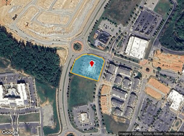
260 Schofield Dr, Midlothian, VA 23113
NEARBY LISTINGS FOR SALE OR LEASE
-
-
View all Midlothian listings for sale on LoopNet.com
Property Detail
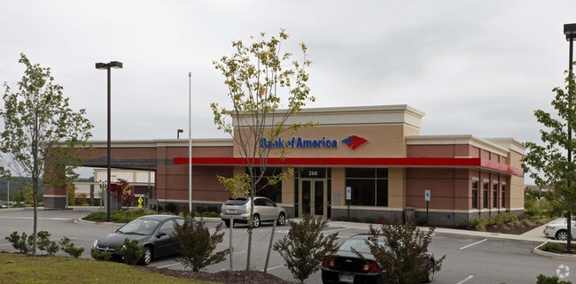
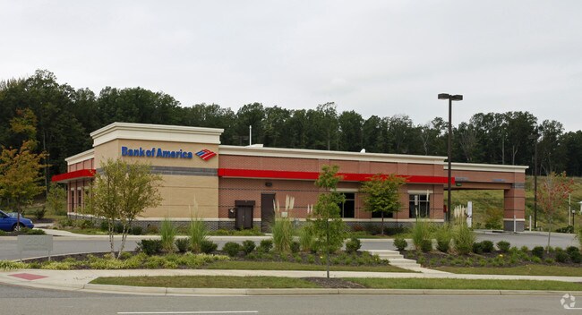
260 Schofield Dr
716-71-21-24-700-000
Outparcel 6 (Bank Of America)
Financialbuilding
OUTPARCEL 6 (BANK OF AMERICA)
X
Chesterfield
51145C0165C
Virginia
2025
1.50 AC
2025
Midlothian Village
100924
Richmond VA
4,536 SF
Richmond, VA
DEMOGRAPHICS near 260 Schofield Dr
1 Mile
3 Mile
5 Mile
2024 Total Population
3,628
23,153
65,402
2029 Population
4,064
25,652
72,174
Pop Growth 2024-2029
+ 12.02%
+ 10.79%
+ 10.35%
Average Age
40
42
41
2024 Total Households
1,321
8,796
24,343
HH Growth 2024-2029
+ 12.11%
+ 10.87%
+ 10.42%
Median Household Inc
$134,091
$120,838
$122,723
Avg Household Size
2.70
2.60
2.60
2024 Avg HH Vehicles
2.00
2.00
2.00
Median Home Value
$545,117
$477,692
$430,350
Median Year Built
2007
2004
1999
Nearby Places
- Restaurants
- Banks
- Shops
- Fitness
- Groceries
PUBLIC TRANSPORTATION
AIRPORT
Richmond International
DRIVE
WALK
Distance
Richmond International
45 min
27.9 mi
Freight Ports
Virginia Port Authority - Richmond
DRIVE
WALK
Distance
Virginia Port Authority - Richmond
35 min
18.0 mi
Nearby Properties
Address
Land Use
TOTAL SIZE
Lot Size
Zoning
Address
Land Use
TOTAL SIZE
Lot Size
Zoning
578,400 SF
6.77 AC
I2 - GEN I
Address
Land Use
TOTAL SIZE
Lot Size
Zoning
5,720 SF
117.22 AC
R9 - SINGL
Address
Land Use
TOTAL SIZE
Lot Size
Zoning
332,521 SF
77.65 AC
I2 - GEN I
Address
Land Use
TOTAL SIZE
Lot Size
Zoning
112,053 SF
44.11 AC
R9 - SINGL
Address
Land Use
TOTAL SIZE
Lot Size
Zoning
8.90 AC
VC-PD
Address
Land Use
TOTAL SIZE
Lot Size
Zoning
100 SF
4.46 AC
I2 - GEN I
Address
Land Use
TOTAL SIZE
Lot Size
Zoning
100 SF
8.12 AC
C3 - COMMU
Address
Land Use
TOTAL SIZE
Lot Size
Zoning
241,433 SF
68.39 AC
R15 - SING
Address
Land Use
TOTAL SIZE
Lot Size
Zoning
163,704 SF
10.16 AC
I2 - GEN I
Address
Land Use
TOTAL SIZE
Lot Size
Zoning
77,008 SF
8.55 AC
I2 - GEN I
Address
Land Use
TOTAL SIZE
Lot Size
Zoning
174,840 SF
21.13 AC
R7 - SINGL
Address
Land Use
TOTAL SIZE
Lot Size
Zoning
99,934 SF
81.69 AC
A - AGRICU
Address
Land Use
TOTAL SIZE
Lot Size
Zoning
62,636 SF
9.14 AC
RMF - RES,
Address
Land Use
TOTAL SIZE
Lot Size
Zoning
49,510 SF
8.86 AC
C3 - COMMU
Address
Land Use
TOTAL SIZE
Lot Size
Zoning
310.29 AC
C3 - COMMU
Address
Land Use
TOTAL SIZE
Lot Size
Zoning
132,360 SF
14.76 AC
I2 - GEN I
Address
Land Use
TOTAL SIZE
Lot Size
Zoning
111,778 SF
9.23 AC
C3 - COMMU
Address
Land Use
TOTAL SIZE
Lot Size
Zoning
93,925 SF
21.04 AC
A - AGRICU
Address
Land Use
TOTAL SIZE
Lot Size
Zoning
21,211 SF
3.53 AC
R7 - SINGL
Address
Land Use
TOTAL SIZE
Lot Size
Zoning
33,817 SF
1.71 AC
I1 - LT IN
Address
Land Use
TOTAL SIZE
Lot Size
Zoning
249.81 AC
RTH - RES,
Address
Land Use
TOTAL SIZE
Lot Size
Zoning
210.30 AC
C3 - COMMU
Address
Land Use
TOTAL SIZE
Lot Size
Zoning
114,616 SF
8.09 AC
R9 - SINGL
Address
Land Use
TOTAL SIZE
Lot Size
Zoning
54,804 SF
0.61 AC
I2 - GEN I
Address
Land Use
TOTAL SIZE
Lot Size
Zoning
25,814 SF
2.20 AC
A - AGRICU
Address
Land Use
TOTAL SIZE
Lot Size
Zoning
31,563 SF
3.66 AC
C3 - COMMU
Address
Land Use
TOTAL SIZE
Lot Size
Zoning
96,443 SF
7.05 AC
I1 - LT IN
Address
Land Use
TOTAL SIZE
Lot Size
Zoning
49.63 AC
C3 - COMMU
Address
Land Use
TOTAL SIZE
Lot Size
Zoning
82,500 SF
9 AC
I1 - LT IN
The World's #1 Commercial Real Estate Marketplace
Connect with us
© 2025 CoStar Group
The information above has been obtained from sources believed reliable. While we do not doubt its accuracy we have not verified it and make no guarantee, warranty or representation about it. It is your responsibility to independently confirm its accuracy and completeness. Any projections, opinions, assumptions, or estimates used are for example only and do not represent the current or future performance of the property. The value of this transaction to you depends on tax and other factors which should be evaluated by your tax, financial, and legal advisors. You and your advisors should conduct a careful, independent investigation of the property to determine to your satisfaction the suitability of the property for your needs.