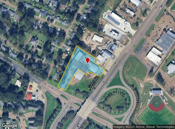
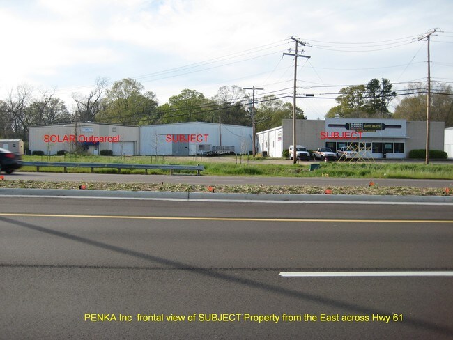
Property Record
260 Sgt Prentiss Dr, Natchez, MS 39120

This Property Is For Sale
NEARBY LISTINGS FOR SALE OR LEASE
Property Detail
260 Sgt Prentiss Dr
0076-0001-0001B
B&L PT OAKLAND 46-104A-6 (AT&T)
Officebuilding
Adams
X
Mississippi
28001C0190D
2.54 AC
2024
Hattiesburg/South Area
2024
Other Market Areas
000600
Natchez, MS-LA
3,503 SF
DEMOGRAPHICS near 260 Sgt Prentiss Dr
1 Mile
3 Mile
5 Mile
2024 Total Population
3,036
16,621
24,639
2029 Population
2,886
15,874
23,495
Pop Growth 2024-2029
(4.94%)
(4.49%)
(4.64%)
Average Age
41
43
42
2024 Total Households
1,400
7,499
10,849
HH Growth 2024-2029
(4.71%)
(4.28%)
(4.43%)
Median Household Inc
$31,111
$31,330
$34,194
Avg Household Size
2.10
2.10
2.20
2024 Avg HH Vehicles
2.00
2.00
2.00
Median Home Value
$82,162
$97,887
$103,992
Median Year Built
1960
1963
1966
Nearby Places
Map Layers
Map Styles
 Street
 Aerial
- Restaurants
- Banks
- Shops
- Fitness
- Groceries
Nearby Properties
Address
Land Use
TOTAL SIZE
Lot Size
Zoning
Address
Land Use
TOTAL SIZE
Lot Size
Zoning
91.24 AC
RVR
Address
Land Use
TOTAL SIZE
Lot Size
Zoning
140,378 SF
24.10 AC
SUD
Address
Land Use
TOTAL SIZE
Lot Size
Zoning
1.73 AC
B3
Address
Land Use
TOTAL SIZE
Lot Size
Zoning
0.29 AC
B2
Address
Land Use
TOTAL SIZE
Lot Size
Zoning
Address
Land Use
TOTAL SIZE
Lot Size
Zoning
178,600 SF
25 AC
B4
Address
Land Use
TOTAL SIZE
Lot Size
Zoning
13,431 SF
2.47 AC
B4
Address
Land Use
TOTAL SIZE
Lot Size
Zoning
1,080 SF
145 AC
SUD
Address
Land Use
TOTAL SIZE
Lot Size
Zoning
95,821 SF
9.81 AC
I1
Address
Land Use
TOTAL SIZE
Lot Size
Zoning
Address
Land Use
TOTAL SIZE
Lot Size
Zoning
24,725 SF
1.10 AC
R4
Address
Land Use
TOTAL SIZE
Lot Size
Zoning
8,248 SF
0.68 AC
B2
Address
Land Use
TOTAL SIZE
Lot Size
Zoning
11,645 SF
3.25 AC
B2
Address
Land Use
TOTAL SIZE
Lot Size
Zoning
21 AC
R1
Address
Land Use
TOTAL SIZE
Lot Size
Zoning
8,960 SF
0.67 AC
R3
Address
Land Use
TOTAL SIZE
Lot Size
Zoning
44,504 SF
2.09 AC
B4
Address
Land Use
TOTAL SIZE
Lot Size
Zoning
25,000 SF
2.99 AC
B4
Address
Land Use
TOTAL SIZE
Lot Size
Zoning
14,033 SF
1 AC
B2
Address
Land Use
TOTAL SIZE
Lot Size
Zoning
48,458 SF
2.27 AC
B2
Address
Land Use
TOTAL SIZE
Lot Size
Zoning
15,582 SF
12.48 AC
B2
Address
Land Use
TOTAL SIZE
Lot Size
Zoning
2,819 SF
5.17 AC
R4
Address
Land Use
TOTAL SIZE
Lot Size
Zoning
246,514 SF
31.20 AC
B4
Address
Land Use
TOTAL SIZE
Lot Size
Zoning
45,354 SF
1.17 AC
B3
Address
Land Use
TOTAL SIZE
Lot Size
Zoning
43,115 SF
1.60 AC
Address
Land Use
TOTAL SIZE
Lot Size
Zoning
Address
Land Use
TOTAL SIZE
Lot Size
Zoning
73,497 SF
1.04 AC
B3
Address
Land Use
TOTAL SIZE
Lot Size
Zoning
576 SF
1.80 AC
B2
Address
Land Use
TOTAL SIZE
Lot Size
Zoning
31,827 SF
1.29 AC
Address
Land Use
TOTAL SIZE
Lot Size
Zoning
11,684 SF
4.77 AC
B4
Address
Land Use
TOTAL SIZE
Lot Size
Zoning
14,135 SF
0.73 AC
B3
The World's #1 Commercial Real Estate Marketplace
Connect with us
© 2025 CoStar Group
The information above has been obtained from sources believed reliable. While we do not doubt its accuracy we have not verified it and make no guarantee, warranty or representation about it. It is your responsibility to independently confirm its accuracy and completeness. Any projections, opinions, assumptions, or estimates used are for example only and do not represent the current or future performance of the property. The value of this transaction to you depends on tax and other factors which should be evaluated by your tax, financial, and legal advisors. You and your advisors should conduct a careful, independent investigation of the property to determine to your satisfaction the suitability of the property for your needs.