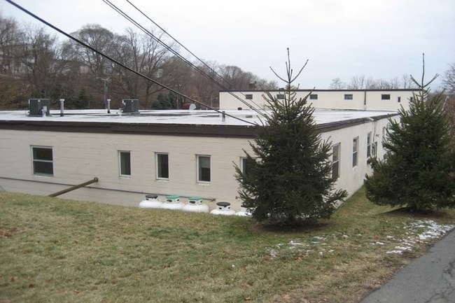
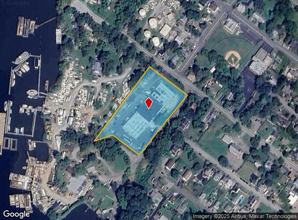
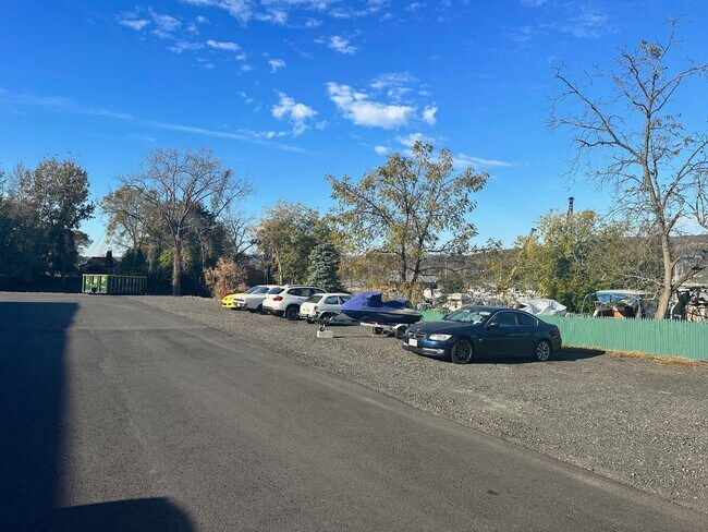
Property Record
260 6Th St, Verplanck, NY 10596

Current Lease Availabilities
NEARBY LISTINGS FOR SALE OR LEASE
-
-
-
-
-
No Photo
-
View all Verplanck listings for lease on LoopNet.com
Property Detail
260 6Th St
New York-Jersey City-White Plains, NY-NJ
9.02L-001-001
2289-054-005-00001-000-0001
Westchester
Distributionwarehouseregional
New York
X
1.000
36087C0039G
3.22 AC
2025
Northwest
2024
Westchester/So Connecticut
014604
DEMOGRAPHICS near 260 6Th St
1 Mile
3 Mile
5 Mile
2024 Total Population
1,998
25,400
88,742
2029 Population
1,882
24,889
87,017
Pop Growth 2024-2029
(5.81%)
(2.01%)
(1.94%)
Average Age
43
43
41
2024 Total Households
799
9,051
31,101
HH Growth 2024-2029
(6.13%)
(2.23%)
(2.13%)
Median Household Inc
$98,186
$98,645
$94,153
Avg Household Size
2.40
2.60
2.70
2024 Avg HH Vehicles
2.00
2.00
2.00
Median Home Value
$407,447
$401,326
$406,440
Median Year Built
1961
1961
1966
Nearby Places
- Restaurants
- Banks
- Shops
- Fitness
- Groceries
PUBLIC TRANSPORTATION
COMMUTER RAIL
Cortlandt Station (Hudson Line - Metro-North Commuter Railroad Company (Metro-North))
DRIVE
WALK
Distance
Cortlandt Station (Hudson Line - Metro-North Commuter Railroad Company (Metro-North))
8 min
2.9 mi
Peekskill Station (Hudson Line - Metro-North Commuter Railroad Company (Metro-North))
DRIVE
WALK
Distance
Peekskill Station (Hudson Line - Metro-North Commuter Railroad Company (Metro-North))
8 min
3.3 mi
AIRPORT
Westchester County
DRIVE
WALK
Distance
Westchester County
45 min
26.1 mi
New York Stewart International
DRIVE
WALK
Distance
New York Stewart International
49 min
27.7 mi
Freight Ports
NY - Red Hook Container Terminal
DRIVE
WALK
Distance
NY - Red Hook Container Terminal
82 min
53.0 mi
Nearby Properties
Address
Land Use
TOTAL SIZE
Lot Size
Zoning
Address
Land Use
TOTAL SIZE
Lot Size
Zoning
Address
Land Use
TOTAL SIZE
Lot Size
Zoning
43,336 SF
96.77 AC
APRP
Address
Land Use
TOTAL SIZE
Lot Size
Zoning
188.01 AC
Address
Land Use
TOTAL SIZE
Lot Size
Zoning
Address
Land Use
TOTAL SIZE
Lot Size
Zoning
79,449 SF
10.40 AC
915
Address
Land Use
TOTAL SIZE
Lot Size
Zoning
106,416 SF
7.74 AC
915
Address
Land Use
TOTAL SIZE
Lot Size
Zoning
Address
Land Use
TOTAL SIZE
Lot Size
Zoning
157 AC
Address
Land Use
TOTAL SIZE
Lot Size
Zoning
2 AC
RR
Address
Land Use
TOTAL SIZE
Lot Size
Zoning
74.84 AC
Address
Land Use
TOTAL SIZE
Lot Size
Zoning
2.45 AC
964
Address
Land Use
TOTAL SIZE
Lot Size
Zoning
90,133 SF
11.80 AC
362
Address
Land Use
TOTAL SIZE
Lot Size
Zoning
49.60 AC
963
Address
Land Use
TOTAL SIZE
Lot Size
Zoning
13,935 SF
6.30 AC
964
Address
Land Use
TOTAL SIZE
Lot Size
Zoning
28,357 SF
0.01 AC
963
Address
Land Use
TOTAL SIZE
Lot Size
Zoning
19,436 SF
3.39 AC
964
Address
Land Use
TOTAL SIZE
Lot Size
Zoning
4.50 AC
963
Address
Land Use
TOTAL SIZE
Lot Size
Zoning
94,493 SF
9.57 AC
BU
Address
Land Use
TOTAL SIZE
Lot Size
Zoning
4.80 AC
RW
Address
Land Use
TOTAL SIZE
Lot Size
Zoning
0.92 AC
R1
Address
Land Use
TOTAL SIZE
Lot Size
Zoning
12.20 AC
964
Address
Land Use
TOTAL SIZE
Lot Size
Zoning
7.10 AC
964
Address
Land Use
TOTAL SIZE
Lot Size
Zoning
4,059 SF
35 AC
964
Address
Land Use
TOTAL SIZE
Lot Size
Zoning
43,138 SF
12.40 AC
RR
Address
Land Use
TOTAL SIZE
Lot Size
Zoning
4.50 AC
963
Address
Land Use
TOTAL SIZE
Lot Size
Zoning
44.39 AC
963
Address
Land Use
TOTAL SIZE
Lot Size
Zoning
27.60 AC
965
Address
Land Use
TOTAL SIZE
Lot Size
Zoning
20,610 SF
4.70 AC
964
Address
Land Use
TOTAL SIZE
Lot Size
Zoning
Address
Land Use
TOTAL SIZE
Lot Size
Zoning
The World's #1 Commercial Real Estate Marketplace
Connect with us
© 2025 CoStar Group
The information above has been obtained from sources believed reliable. While we do not doubt its accuracy we have not verified it and make no guarantee, warranty or representation about it. It is your responsibility to independently confirm its accuracy and completeness. Any projections, opinions, assumptions, or estimates used are for example only and do not represent the current or future performance of the property. The value of this transaction to you depends on tax and other factors which should be evaluated by your tax, financial, and legal advisors. You and your advisors should conduct a careful, independent investigation of the property to determine to your satisfaction the suitability of the property for your needs.