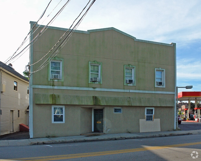
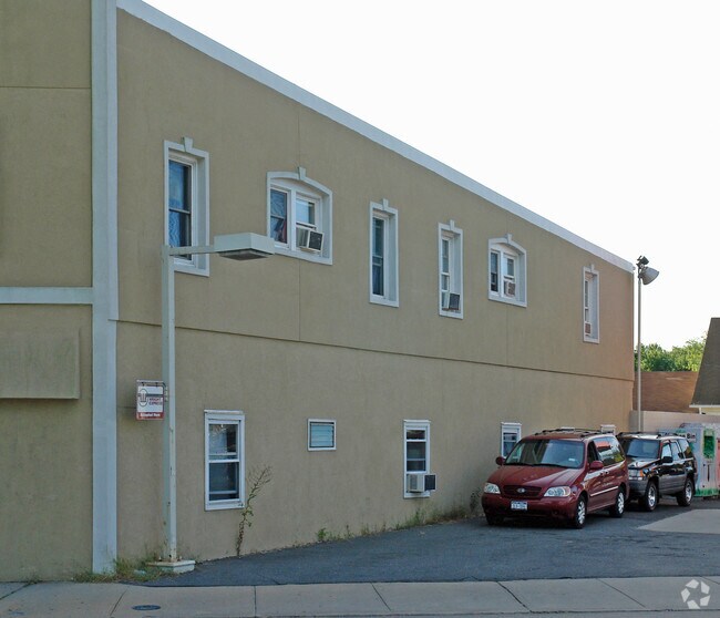
Property Record
260 W Main St, Patchogue, NY 11772
NEARBY LISTINGS FOR SALE OR LEASE
-
-
View all Patchogue listings for sale on LoopNet.com
Property Detail
260 W Main St
Nassau County-Suffolk County, NY
Patchogue (M To Z)
0204-008-00-10-00-002-000
N W MAIN ST E NRLA REALTY INC S SPN
Commercialnec
Suffolk
X
New York
36103C0694H
3
2024
0.21 AC
2024
Patchogue
158902
Long Island (New York)
DEMOGRAPHICS near 260 W Main St
1 mile
3 mile
5 mile
2024 Total Population
13,044
68,797
156,513
2029 Population
12,779
68,027
154,983
Pop Growth 2024-2029
(2.03%)
(1.12%)
(0.98%)
Average Age
42
42
42
2024 Total Households
5,482
25,971
55,408
HH Growth 2024-2029
(2.21%)
(1.32%)
(1.18%)
Median Household Inc
$95,745
$110,733
$112,185
Avg Household Size
2.30
2.60
2.70
2024 Avg HH Vehicles
2.00
2.00
2.00
Median Home Value
$454,229
$463,672
$456,907
Median Year Built
1967
1971
1972
Nearby Places
Map Layers
Map Styles
 Street
 Aerial
Transit
 Traffic
 Biking
Places
Listings with unknown addresses are not visible on the map
- Restaurants
- Banks
- Shops
- Fitness
- Groceries
PUBLIC TRANSPORTATION
TRANSIT/SUBWAY
Patchogue Station (Montauk Branch - Long Island Rail Road)
Drive
Walk
Distance
Patchogue Station (Montauk Branch - Long Island Rail Road)
2 min
13 min
0.7 mi
COMMUTER RAIL
Patchogue Station (Montauk Branch - Long Island Rail Road)
Drive
Walk
Distance
Patchogue Station (Montauk Branch - Long Island Rail Road)
2 min
12 min
0.6 mi
Sayville Station (Montauk Branch - Long Island Rail Road)
Drive
Walk
Distance
Sayville Station (Montauk Branch - Long Island Rail Road)
8 min
4.1 mi
AIRPORT
Long Island MacArthur
Drive
Walk
Distance
Long Island MacArthur
13 min
5.8 mi
Nearby Properties
Address
Land Use
TOTAL SIZE
Lot Size
Zoning
Address
Land Use
TOTAL SIZE
Lot Size
Zoning
30.25 AC
CA
Address
Land Use
TOTAL SIZE
Lot Size
Zoning
33.47 AC
AA
Address
Land Use
TOTAL SIZE
Lot Size
Zoning
3,060 SF
0.22 AC
VILLA
Address
Land Use
TOTAL SIZE
Lot Size
Zoning
29.86 AC
CA
Address
Land Use
TOTAL SIZE
Lot Size
Zoning
26.28 AC
CA
Address
Land Use
TOTAL SIZE
Lot Size
Zoning
26,811 SF
43.20 AC
CA
Address
Land Use
TOTAL SIZE
Lot Size
Zoning
7,290 SF
15.71 AC
CA
Address
Land Use
TOTAL SIZE
Lot Size
Zoning
3,034 SF
0.20 AC
VILLA
Address
Land Use
TOTAL SIZE
Lot Size
Zoning
2,196 SF
0.33 AC
VILLA
Address
Land Use
TOTAL SIZE
Lot Size
Zoning
4,220 SF
2.07 AC
R15
Address
Land Use
TOTAL SIZE
Lot Size
Zoning
3,766 SF
0.59 AC
R15
Address
Land Use
TOTAL SIZE
Lot Size
Zoning
4,446 SF
1.17 AC
CR200
Address
Land Use
TOTAL SIZE
Lot Size
Zoning
96 SF
18.29 AC
BUS3
Address
Land Use
TOTAL SIZE
Lot Size
Zoning
16 AC
AA
Address
Land Use
TOTAL SIZE
Lot Size
Zoning
3,025 SF
5.60 AC
AA
Address
Land Use
TOTAL SIZE
Lot Size
Zoning
23.90 AC
AA
Address
Land Use
TOTAL SIZE
Lot Size
Zoning
5,858 SF
1.73 AC
R40
Address
Land Use
TOTAL SIZE
Lot Size
Zoning
2,276 SF
0.27 AC
VILLA
Address
Land Use
TOTAL SIZE
Lot Size
Zoning
2,724 SF
0.32 AC
VILLA
Address
Land Use
TOTAL SIZE
Lot Size
Zoning
4,000 SF
0.30 AC
VILLA
Address
Land Use
TOTAL SIZE
Lot Size
Zoning
2,046 SF
0.21 AC
VILLA
Address
Land Use
TOTAL SIZE
Lot Size
Zoning
12.70 AC
IND1
Address
Land Use
TOTAL SIZE
Lot Size
Zoning
5.01 AC
AA278
Address
Land Use
TOTAL SIZE
Lot Size
Zoning
42.37 AC
Address
Land Use
TOTAL SIZE
Lot Size
Zoning
6,968 SF
1.15 AC
R40
Address
Land Use
TOTAL SIZE
Lot Size
Zoning
4,840 SF
1.84 AC
VILLA
Address
Land Use
TOTAL SIZE
Lot Size
Zoning
4,225 SF
1.02 AC
R40
Address
Land Use
TOTAL SIZE
Lot Size
Zoning
12.14 AC
BUS3
Address
Land Use
TOTAL SIZE
Lot Size
Zoning
3,676 SF
1.84 AC
VILLA
Address
Land Use
TOTAL SIZE
Lot Size
Zoning
4,825 SF
1.84 AC
VILLA
The World's #1 Commercial Real Estate Marketplace
Connect with us
© 2026 CoStar Group
The information above has been obtained from sources believed reliable. While we do not doubt its accuracy we have not verified it and make no guarantee, warranty or representation about it. It is your responsibility to independently confirm its accuracy and completeness. Any projections, opinions, assumptions, or estimates used are for example only and do not represent the current or future performance of the property. The value of this transaction to you depends on tax and other factors which should be evaluated by your tax, financial, and legal advisors. You and your advisors should conduct a careful, independent investigation of the property to determine to your satisfaction the suitability of the property for your needs.