Property Record
2600 2Nd St Ne, Minneapolis, MN 55418


NEARBY LISTINGS FOR SALE OR LEASE
Property Detail
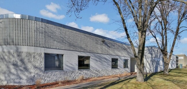
2600 2Nd St Ne
Minneapolis-St. Paul-Bloomington, MN-WI
B S Wrights Addn To Mpls
11-029-24-23-0127
LOT 001 BLOCK 005 A B S WRIGHTS ADDN TO MPLS LOTS 1 THRU 5 INCL AND LOTS 8 THRU 12 INCL BLK 5 INCL ADJ VAC ALLEY AND INCL ADJ VAC S 57 FT OF 26 1/2 AVE NE EXCEPT THAT PART LYING W OF FOL T 275.00 X 295.00
Commercialnec
Hennepin
X
Minnesota
27053C0219F
1
2024
1.85 AC
2024
Minneapolis
001100
Minneapolis/St Paul
30,696 SF
DEMOGRAPHICS near 2600 2Nd St Ne
1 Mile
3 Mile
5 Mile
2024 Total Population
10,650
176,154
423,203
2029 Population
10,298
174,471
418,365
Pop Growth 2024-2029
(3.31%)
(0.96%)
(1.14%)
Average Age
36
36
37
2024 Total Households
4,652
74,683
182,080
HH Growth 2024-2029
(3.65%)
(0.79%)
(1.10%)
Median Household Inc
$58,236
$69,077
$64,684
Avg Household Size
2.20
2.20
2.10
2024 Avg HH Vehicles
1.00
1.00
1.00
Median Home Value
$278,283
$267,793
$283,371
Median Year Built
1948
1963
1965
Nearby Places
Map Layers
Map Styles
 Street
 Aerial
- Restaurants
- Banks
- Shops
- Fitness
- Groceries
PUBLIC TRANSPORTATION
COMMUTER RAIL
Target Field Station (Northstar Corridor - Northstar Commuter Rail)
DRIVE
WALK
Distance
Target Field Station (Northstar Corridor - Northstar Commuter Rail)
9 min
3.2 mi
Fridley Station (Northstar Corridor - Northstar Commuter Rail)
DRIVE
WALK
Distance
Fridley Station (Northstar Corridor - Northstar Commuter Rail)
9 min
5.3 mi
AIRPORT
Minneapolis-St Paul International/Wold-Chamberlain
DRIVE
WALK
Distance
Minneapolis-St Paul International/Wold-Chamberlain
27 min
13.3 mi
SALE & LEASE HISTORY
LISTING DATE
SALE/LEASE

Jan 11, 2024
For Sale
Nearby Properties
Address
Land Use
TOTAL SIZE
Lot Size
Zoning
Address
Land Use
TOTAL SIZE
Lot Size
Zoning
1,462,182 SF
1 AC
B4-2
Address
Land Use
TOTAL SIZE
Lot Size
Zoning
2,094,377 SF
2.10 AC
B4-2
Address
Land Use
TOTAL SIZE
Lot Size
Zoning
1,821,999 SF
2.51 AC
B4-2
Address
Land Use
TOTAL SIZE
Lot Size
Zoning
Address
Land Use
TOTAL SIZE
Lot Size
Zoning
1,934,403 SF
1.67 AC
B4-2
Address
Land Use
TOTAL SIZE
Lot Size
Zoning
1,021,060 SF
1.71 AC
B4S-2
Address
Land Use
TOTAL SIZE
Lot Size
Zoning
2,282,334 SF
3.25 AC
B4-2
Address
Land Use
TOTAL SIZE
Lot Size
Zoning
1,054,492 SF
1.70 AC
B4-1
Address
Land Use
TOTAL SIZE
Lot Size
Zoning
495,632 SF
1.72 AC
C1
Address
Land Use
TOTAL SIZE
Lot Size
Zoning
1,208,190 SF
1.20 AC
B4-2
Address
Land Use
TOTAL SIZE
Lot Size
Zoning
621,608 SF
1.03 AC
B4-2
Address
Land Use
TOTAL SIZE
Lot Size
Zoning
907,129 SF
1.65 AC
B4-1
Address
Land Use
TOTAL SIZE
Lot Size
Zoning
442,731 SF
0.97 AC
B4S-2
Address
Land Use
TOTAL SIZE
Lot Size
Zoning
1,044,454 SF
1.08 AC
B4-2
Address
Land Use
TOTAL SIZE
Lot Size
Zoning
1,261,574 SF
2.52 AC
B4-2
Address
Land Use
TOTAL SIZE
Lot Size
Zoning
695,624 SF
3.67 AC
C2
Address
Land Use
TOTAL SIZE
Lot Size
Zoning
2.67 AC
C3A
Address
Land Use
TOTAL SIZE
Lot Size
Zoning
615,172 SF
1.98 AC
I1
Address
Land Use
TOTAL SIZE
Lot Size
Zoning
1 SF
69.72 AC
I3
Address
Land Use
TOTAL SIZE
Lot Size
Zoning
722,423 SF
1.33 AC
B4-2
Address
Land Use
TOTAL SIZE
Lot Size
Zoning
1,424,796 SF
1.13 AC
B4-1
Address
Land Use
TOTAL SIZE
Lot Size
Zoning
557,654 SF
3.15 AC
C2
Address
Land Use
TOTAL SIZE
Lot Size
Zoning
478,616 SF
2.28 AC
C2
Address
Land Use
TOTAL SIZE
Lot Size
Zoning
513,403 SF
0.73 AC
C2
Address
Land Use
TOTAL SIZE
Lot Size
Zoning
1,235,416 SF
1.12 AC
B4-2
Address
Land Use
TOTAL SIZE
Lot Size
Zoning
323,404 SF
2.54 AC
B4S-2
Address
Land Use
TOTAL SIZE
Lot Size
Zoning
403,792 SF
2.51 AC
B4N
Address
Land Use
TOTAL SIZE
Lot Size
Zoning
618,841 SF
1.53 AC
B4N
Address
Land Use
TOTAL SIZE
Lot Size
Zoning
618,841 SF
1.54 AC
B4S-2
Address
Land Use
TOTAL SIZE
Lot Size
Zoning
832,819 SF
0.64 AC
B4-2
The World's #1 Commercial Real Estate Marketplace
Connect with us
© 2025 CoStar Group
The information above has been obtained from sources believed reliable. While we do not doubt its accuracy we have not verified it and make no guarantee, warranty or representation about it. It is your responsibility to independently confirm its accuracy and completeness. Any projections, opinions, assumptions, or estimates used are for example only and do not represent the current or future performance of the property. The value of this transaction to you depends on tax and other factors which should be evaluated by your tax, financial, and legal advisors. You and your advisors should conduct a careful, independent investigation of the property to determine to your satisfaction the suitability of the property for your needs.