Property Record
2600 8Th St Ne, Canton, OH 44704
NEARBY LISTINGS FOR SALE OR LEASE
Property Detail
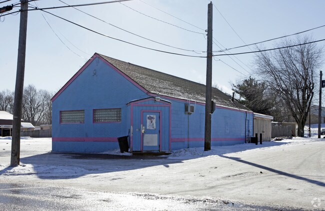
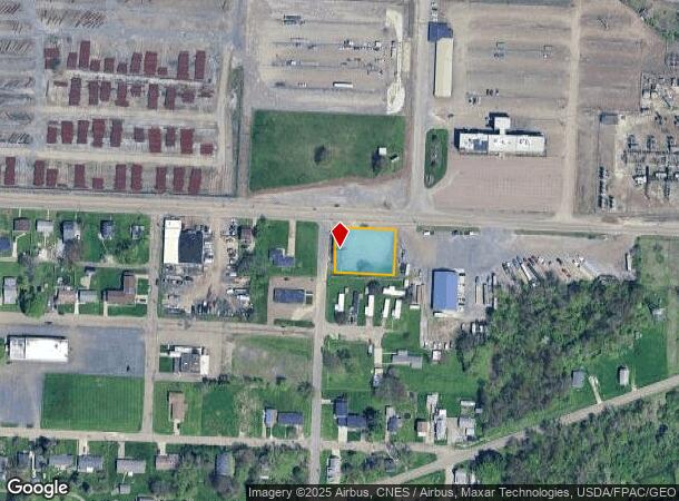
2600 8Th St Ne
00244649
22692,22693,22694, 22695 WH EA
Restaurantbuilding
Stark
X
Ohio
39151C0237E
0.44 AC
2025
Stark County
2025
Cleveland
713100
Canton-Massillon, OH
1,580 SF
DEMOGRAPHICS near 2600 8Th St Ne
1 Mile
3 Mile
5 Mile
2024 Total Population
5,097
53,875
121,048
2029 Population
5,137
53,934
120,559
Pop Growth 2024-2029
+ 0.78%
+ 0.11%
(0.40%)
Average Age
40
39
41
2024 Total Households
2,129
22,741
51,427
HH Growth 2024-2029
+ 0.66%
+ 0.04%
(0.44%)
Median Household Inc
$33,589
$36,039
$45,493
Avg Household Size
2.30
2.20
2.20
2024 Avg HH Vehicles
2.00
1.00
2.00
Median Home Value
$71,455
$78,504
$122,263
Median Year Built
1948
1949
1954
Nearby Places
Map Layers
Map Styles
 Street
 Aerial
- Restaurants
- Banks
- Shops
- Fitness
- Groceries
PUBLIC TRANSPORTATION
AIRPORT
Akron-Canton Regional
DRIVE
WALK
Distance
Akron-Canton Regional
18 min
12.2 mi
SALE & LEASE HISTORY
LISTING DATE
SALE/LEASE

Feb 20, 2020
For Sale
Nearby Properties
Address
Land Use
TOTAL SIZE
Lot Size
Zoning
Address
Land Use
TOTAL SIZE
Lot Size
Zoning
521,112 SF
14.28 AC
Address
Land Use
TOTAL SIZE
Lot Size
Zoning
272,888 SF
27.61 AC
Address
Land Use
TOTAL SIZE
Lot Size
Zoning
327,119 SF
50.74 AC
Address
Land Use
TOTAL SIZE
Lot Size
Zoning
1,069,826 SF
158.31 AC
Address
Land Use
TOTAL SIZE
Lot Size
Zoning
345,570 SF
29.76 AC
Address
Land Use
TOTAL SIZE
Lot Size
Zoning
118,619 SF
2.14 AC
Address
Land Use
TOTAL SIZE
Lot Size
Zoning
423,783 SF
26.11 AC
Address
Land Use
TOTAL SIZE
Lot Size
Zoning
476,634 SF
15.08 AC
Address
Land Use
TOTAL SIZE
Lot Size
Zoning
316,099 SF
8.47 AC
Address
Land Use
TOTAL SIZE
Lot Size
Zoning
82,950 SF
Address
Land Use
TOTAL SIZE
Lot Size
Zoning
158,390 SF
0.92 AC
Address
Land Use
TOTAL SIZE
Lot Size
Zoning
1,096,089 SF
144.96 AC
Address
Land Use
TOTAL SIZE
Lot Size
Zoning
180,088 SF
71.80 AC
Address
Land Use
TOTAL SIZE
Lot Size
Zoning
0.35 AC
Address
Land Use
TOTAL SIZE
Lot Size
Zoning
59,211 SF
3.53 AC
Address
Land Use
TOTAL SIZE
Lot Size
Zoning
57,852 SF
3.32 AC
Address
Land Use
TOTAL SIZE
Lot Size
Zoning
227,370 SF
0.77 AC
Address
Land Use
TOTAL SIZE
Lot Size
Zoning
57,075 SF
4.25 AC
Address
Land Use
TOTAL SIZE
Lot Size
Zoning
227,370 SF
0.77 AC
Address
Land Use
TOTAL SIZE
Lot Size
Zoning
124,758 SF
6.22 AC
Address
Land Use
TOTAL SIZE
Lot Size
Zoning
217,695 SF
19.46 AC
Address
Land Use
TOTAL SIZE
Lot Size
Zoning
135,840 SF
21 AC
Address
Land Use
TOTAL SIZE
Lot Size
Zoning
58,021 SF
13.25 AC
Address
Land Use
TOTAL SIZE
Lot Size
Zoning
52,876 SF
4.96 AC
Address
Land Use
TOTAL SIZE
Lot Size
Zoning
73,890 SF
0.77 AC
Address
Land Use
TOTAL SIZE
Lot Size
Zoning
118,052 SF
12.52 AC
Address
Land Use
TOTAL SIZE
Lot Size
Zoning
148,588 SF
1.33 AC
Address
Land Use
TOTAL SIZE
Lot Size
Zoning
63,810 SF
0.44 AC
Address
Land Use
TOTAL SIZE
Lot Size
Zoning
45,482 SF
1.01 AC
Address
Land Use
TOTAL SIZE
Lot Size
Zoning
329,666 SF
4.62 AC
The World's #1 Commercial Real Estate Marketplace
Connect with us
© 2026 CoStar Group
The information above has been obtained from sources believed reliable. While we do not doubt its accuracy we have not verified it and make no guarantee, warranty or representation about it. It is your responsibility to independently confirm its accuracy and completeness. Any projections, opinions, assumptions, or estimates used are for example only and do not represent the current or future performance of the property. The value of this transaction to you depends on tax and other factors which should be evaluated by your tax, financial, and legal advisors. You and your advisors should conduct a careful, independent investigation of the property to determine to your satisfaction the suitability of the property for your needs.