Property Record
2600 Atlantic Ave, Raleigh, NC 27604
Current Lease Availabilities
NEARBY LISTINGS FOR SALE OR LEASE
Property Detail
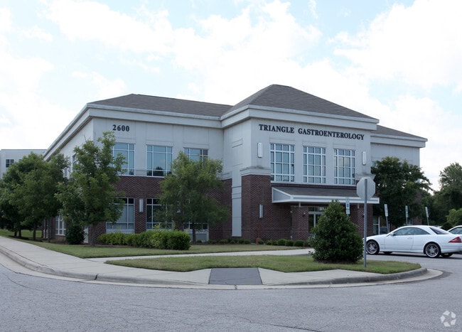
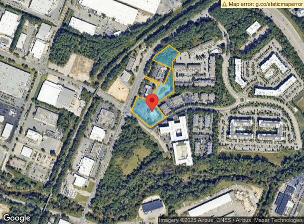
2600 Atlantic Ave
Raleigh, NC
Atlantic Six Forks Center
1715.14-42-1736-000
LO1 ATLANTIC SIX FORKS CENTER BM2016-010
Medicalbuilding
Wake
X
North Carolina
3720171500K
1
2025
4.84 AC
2025
Route 1
052705
Raleigh/Durham
21,786 SF
DEMOGRAPHICS near 2600 Atlantic Ave
1 Mile
3 Mile
5 Mile
2024 Total Population
5,978
95,161
256,274
2029 Population
6,511
103,578
278,922
Pop Growth 2024-2029
+ 8.92%
+ 8.85%
+ 8.84%
Average Age
37
39
38
2024 Total Households
3,109
43,007
108,389
HH Growth 2024-2029
+ 9.01%
+ 9.12%
+ 9.21%
Median Household Inc
$81,203
$77,373
$71,562
Avg Household Size
1.90
2.10
2.20
2024 Avg HH Vehicles
2.00
2.00
2.00
Median Home Value
$318,936
$406,338
$357,405
Median Year Built
1995
1983
1988
Nearby Places
- Restaurants
- Banks
- Shops
- Fitness
- Groceries
PUBLIC TRANSPORTATION
COMMUTER RAIL
Raleigh Union Station (Piedmont - North Carolina by Train (NC Train))
DRIVE
WALK
Distance
Raleigh Union Station (Piedmont - North Carolina by Train (NC Train))
8 min
4.0 mi
AIRPORT
Raleigh-Durham International
DRIVE
WALK
Distance
Raleigh-Durham International
24 min
15.9 mi
Freight Ports
Port of Wilmington
DRIVE
WALK
Distance
Port of Wilmington
157 min
135.6 mi
Nearby Properties
Address
Land Use
TOTAL SIZE
Lot Size
Zoning
Address
Land Use
TOTAL SIZE
Lot Size
Zoning
2,660,245 SF
38.98 AC
CMP
Address
Land Use
TOTAL SIZE
Lot Size
Zoning
1,597,789 SF
13.35 AC
DX-20
Address
Land Use
TOTAL SIZE
Lot Size
Zoning
1,085,654 SF
16.87 AC
OX-5
Address
Land Use
TOTAL SIZE
Lot Size
Zoning
675,817 SF
3.56 AC
DX-12
Address
Land Use
TOTAL SIZE
Lot Size
Zoning
517,826 SF
2.52 AC
DX-7
Address
Land Use
TOTAL SIZE
Lot Size
Zoning
179,565 SF
1.10 AC
DX-7
Address
Land Use
TOTAL SIZE
Lot Size
Zoning
658,580 SF
3.30 AC
PD
Address
Land Use
TOTAL SIZE
Lot Size
Zoning
654,148 SF
1.21 AC
DX-40
Address
Land Use
TOTAL SIZE
Lot Size
Zoning
747,658 SF
11.12 AC
CX-12
Address
Land Use
TOTAL SIZE
Lot Size
Zoning
465,052 SF
2.65 AC
PD
Address
Land Use
TOTAL SIZE
Lot Size
Zoning
364,025 SF
2.19 AC
PD
Address
Land Use
TOTAL SIZE
Lot Size
Zoning
159,921 SF
4.99 AC
DX-5
Address
Land Use
TOTAL SIZE
Lot Size
Zoning
701,923 SF
64.64 AC
RX-5
Address
Land Use
TOTAL SIZE
Lot Size
Zoning
40,024 SF
6.19 AC
DX-3
Address
Land Use
TOTAL SIZE
Lot Size
Zoning
539,902 SF
1.28 AC
O&I-1
Address
Land Use
TOTAL SIZE
Lot Size
Zoning
580,268 SF
9.02 AC
PD
Address
Land Use
TOTAL SIZE
Lot Size
Zoning
354,131 SF
15.23 AC
RX-4
Address
Land Use
TOTAL SIZE
Lot Size
Zoning
201,558 SF
4.05 AC
DX-12
Address
Land Use
TOTAL SIZE
Lot Size
Zoning
544,122 SF
1.49 AC
PD
Address
Land Use
TOTAL SIZE
Lot Size
Zoning
355,931 SF
2.60 AC
PD
Address
Land Use
TOTAL SIZE
Lot Size
Zoning
284,958 SF
3.01 AC
PD
Address
Land Use
TOTAL SIZE
Lot Size
Zoning
420,188 SF
2.14 AC
DX-7
Address
Land Use
TOTAL SIZE
Lot Size
Zoning
506,411 SF
2.52 AC
DX-12
Address
Land Use
TOTAL SIZE
Lot Size
Zoning
395,492 SF
2.33 AC
DX-7
Address
Land Use
TOTAL SIZE
Lot Size
Zoning
366,905 SF
11.24 AC
OX-5
Address
Land Use
TOTAL SIZE
Lot Size
Zoning
289,301 SF
20.67 AC
OX-12
Address
Land Use
TOTAL SIZE
Lot Size
Zoning
282,285 SF
5.29 AC
PD
Address
Land Use
TOTAL SIZE
Lot Size
Zoning
319,136 SF
22.25 AC
OX-12
Address
Land Use
TOTAL SIZE
Lot Size
Zoning
353,930 SF
6.75 AC
DX-12
Address
Land Use
TOTAL SIZE
Lot Size
Zoning
403,782 SF
5.32 AC
RX-7
The World's #1 Commercial Real Estate Marketplace
Connect with us
© 2025 CoStar Group
The information above has been obtained from sources believed reliable. While we do not doubt its accuracy we have not verified it and make no guarantee, warranty or representation about it. It is your responsibility to independently confirm its accuracy and completeness. Any projections, opinions, assumptions, or estimates used are for example only and do not represent the current or future performance of the property. The value of this transaction to you depends on tax and other factors which should be evaluated by your tax, financial, and legal advisors. You and your advisors should conduct a careful, independent investigation of the property to determine to your satisfaction the suitability of the property for your needs.