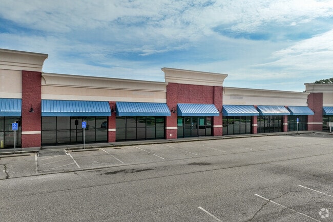
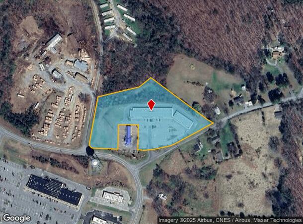
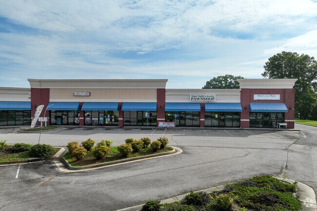
Property Record
2600 Dearing Ford Rd, Altavista, VA 24517

NEARBY LISTINGS FOR SALE OR LEASE
Property Detail
2600 Dearing Ford Rd
069004005001C
DEARING FORD RD
Commercialnec
Campbell
X
Virginia
51019C0525D
4.78 AC
2025
Lynchburg
2025
Other Market Areas
020600
Lynchburg, VA
15,660 SF
DEMOGRAPHICS near 2600 Dearing Ford Rd
1 Mile
3 Mile
5 Mile
2024 Total Population
198
4,596
9,192
2029 Population
195
4,508
9,040
Pop Growth 2024-2029
(1.52%)
(1.91%)
(1.65%)
Average Age
44
43
44
2024 Total Households
83
1,994
4,018
HH Growth 2024-2029
(1.20%)
(1.96%)
(1.62%)
Median Household Inc
$46,250
$39,864
$45,529
Avg Household Size
2.30
2.30
2.30
2024 Avg HH Vehicles
2.00
2.00
2.00
Median Home Value
$110,000
$126,437
$137,004
Median Year Built
1969
1964
1970
Nearby Places
Map Layers
Map Styles
 Street
 Aerial
- Restaurants
- Banks
- Shops
- Fitness
- Groceries
PUBLIC TRANSPORTATION
AIRPORT
Lynchburg Regional/Preston Glenn Field
DRIVE
WALK
Distance
Lynchburg Regional/Preston Glenn Field
29 min
18.6 mi
Freight Ports
Virginia Port Authority - Richmond
DRIVE
WALK
Distance
Virginia Port Authority - Richmond
176 min
124.9 mi
SALE & LEASE HISTORY
LISTING DATE
SALE/LEASE

Sep 25, 2016
For Lease
Sep 23, 2016
For Sale
Oct 10, 2025
For Lease
Mar 24, 2021
For Lease
Mar 11, 2020
For Lease
Mar 06, 2020
For Sale
Jun 18, 2025
For Sale
Feb 29, 2024
For Lease
Nearby Properties
Address
Land Use
TOTAL SIZE
Lot Size
Zoning
Address
Land Use
TOTAL SIZE
Lot Size
Zoning
378,974 SF
99.53 AC
Address
Land Use
TOTAL SIZE
Lot Size
Zoning
60,000 SF
19.33 AC
Address
Land Use
TOTAL SIZE
Lot Size
Zoning
6,660 SF
62.32 AC
Address
Land Use
TOTAL SIZE
Lot Size
Zoning
6.68 AC
R-1
Address
Land Use
TOTAL SIZE
Lot Size
Zoning
94,228 SF
32.64 AC
Address
Land Use
TOTAL SIZE
Lot Size
Zoning
70,966 SF
20.51 AC
Address
Land Use
TOTAL SIZE
Lot Size
Zoning
154,479 SF
20.42 AC
Address
Land Use
TOTAL SIZE
Lot Size
Zoning
45,360 SF
16.05 AC
Address
Land Use
TOTAL SIZE
Lot Size
Zoning
44,302 SF
6.60 AC
Address
Land Use
TOTAL SIZE
Lot Size
Zoning
22,714 SF
0.22 AC
Address
Land Use
TOTAL SIZE
Lot Size
Zoning
150,352 SF
24.92 AC
Address
Land Use
TOTAL SIZE
Lot Size
Zoning
3,159 SF
1.06 AC
Address
Land Use
TOTAL SIZE
Lot Size
Zoning
9,724 SF
3.05 AC
Address
Land Use
TOTAL SIZE
Lot Size
Zoning
31,456 SF
3.59 AC
Address
Land Use
TOTAL SIZE
Lot Size
Zoning
32,536 SF
2.90 AC
Address
Land Use
TOTAL SIZE
Lot Size
Zoning
22,228 SF
0.09 AC
Address
Land Use
TOTAL SIZE
Lot Size
Zoning
8,115 SF
523.50 AC
A1
Address
Land Use
TOTAL SIZE
Lot Size
Zoning
35,236 SF
10.04 AC
Address
Land Use
TOTAL SIZE
Lot Size
Zoning
28,000 SF
4.44 AC
Address
Land Use
TOTAL SIZE
Lot Size
Zoning
59,598 SF
4.07 AC
Address
Land Use
TOTAL SIZE
Lot Size
Zoning
3,232 SF
263.28 AC
A1
Address
Land Use
TOTAL SIZE
Lot Size
Zoning
8,180 SF
10.97 AC
BGC
Address
Land Use
TOTAL SIZE
Lot Size
Zoning
112,536 SF
11.15 AC
Address
Land Use
TOTAL SIZE
Lot Size
Zoning
31,276 SF
12.70 AC
Address
Land Use
TOTAL SIZE
Lot Size
Zoning
5,160 SF
1.99 AC
Address
Land Use
TOTAL SIZE
Lot Size
Zoning
13,920 SF
3.67 AC
Address
Land Use
TOTAL SIZE
Lot Size
Zoning
10,841 SF
0.59 AC
Address
Land Use
TOTAL SIZE
Lot Size
Zoning
6,600 SF
14.42 AC
RSF
Address
Land Use
TOTAL SIZE
Lot Size
Zoning
4,920 SF
2.90 AC
The World's #1 Commercial Real Estate Marketplace
Connect with us
© 2025 CoStar Group
The information above has been obtained from sources believed reliable. While we do not doubt its accuracy we have not verified it and make no guarantee, warranty or representation about it. It is your responsibility to independently confirm its accuracy and completeness. Any projections, opinions, assumptions, or estimates used are for example only and do not represent the current or future performance of the property. The value of this transaction to you depends on tax and other factors which should be evaluated by your tax, financial, and legal advisors. You and your advisors should conduct a careful, independent investigation of the property to determine to your satisfaction the suitability of the property for your needs.