Property Record
2600 E Malone Ave, Sikeston, MO 63801
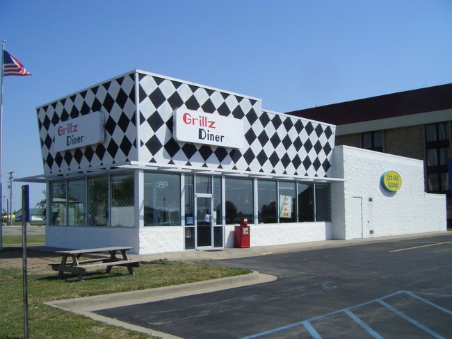

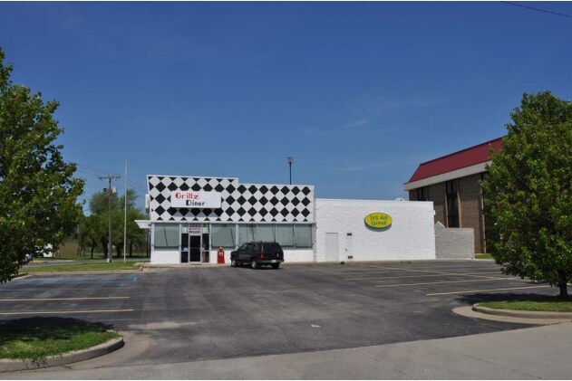
Property Detail
2600 E Malone Ave
Sikeston, MO
PT LOT 2 & 3 TAYLORS SUBD MINER PB 8/8 190.27 X 174.75 I
18-5.0-15.00-000-000-062.20
Scott
Restaurantbuilding
Missouri
AH Areas with a 1% annual chance of shallow flooding, usually in the form of a pond, withan average depth ranging from 1 to 3 feet. These areas have a 26% chance of flooding over the life of a 30-year mortgage.
2-3
2024
0.76 AC
2025
Missouri South Area
780600
Other Market Areas
2,020 SF
NEARBY LISTINGS FOR SALE OR LEASE
-
-
View all Sikeston listings for sale on LoopNet.com
DEMOGRAPHICS near 2600 E Malone Ave
1 mile
3 mile
5 mile
2025 Total Population
1,447
11,188
20,460
2030 Population
1,477
11,199
20,471
Pop Growth 2025-2030
+ 2.07%
+ 0.10%
+ 0.05%
Average Age
42
41
41
2025 Total Households
608
4,626
8,282
HH Growth 2025-2030
+ 1.97%
+ 0.15%
+ 0.06%
Median Household Inc
$50,425
$57,512
$53,896
Avg Household Size
2.30
2.30
2.40
2025 Avg HH Vehicles
2.00
2.00
2.00
Median Home Value
$122,107
$140,109
$149,789
Median Year Built
1980
1976
1976
Nearby Places
Map Layers
Map Styles
 Street
 Aerial
Transit
 Traffic
 Biking
Places
Listings with unknown addresses are not visible on the map
- Restaurants
- Banks
- Shops
- Fitness
- Groceries
Nearby Properties
Address
Land Use
TOTAL SIZE
Lot Size
Zoning
Address
Land Use
TOTAL SIZE
Lot Size
Zoning
2.35 AC
Address
Land Use
TOTAL SIZE
Lot Size
Zoning
4.39 AC
Address
Land Use
TOTAL SIZE
Lot Size
Zoning
2.70 AC
Address
Land Use
TOTAL SIZE
Lot Size
Zoning
26.87 AC
Address
Land Use
TOTAL SIZE
Lot Size
Zoning
2,199,266 SF
11.30 AC
Address
Land Use
TOTAL SIZE
Lot Size
Zoning
13,078 SF
1.54 AC
Address
Land Use
TOTAL SIZE
Lot Size
Zoning
11,376 SF
1.19 AC
Address
Land Use
TOTAL SIZE
Lot Size
Zoning
15,140 SF
2.20 AC
Address
Land Use
TOTAL SIZE
Lot Size
Zoning
1,835 SF
9 AC
Address
Land Use
TOTAL SIZE
Lot Size
Zoning
30,350 SF
4.29 AC
Address
Land Use
TOTAL SIZE
Lot Size
Zoning
91,059 SF
9 AC
Address
Land Use
TOTAL SIZE
Lot Size
Zoning
31,804 SF
2.53 AC
Address
Land Use
TOTAL SIZE
Lot Size
Zoning
210,000 SF
32.77 AC
Address
Land Use
TOTAL SIZE
Lot Size
Zoning
12,294 SF
2.04 AC
Address
Land Use
TOTAL SIZE
Lot Size
Zoning
2.55 AC
Address
Land Use
TOTAL SIZE
Lot Size
Zoning
5,856 SF
1.59 AC
Address
Land Use
TOTAL SIZE
Lot Size
Zoning
14,866 SF
1.52 AC
Address
Land Use
TOTAL SIZE
Lot Size
Zoning
6,887 SF
3.30 AC
Address
Land Use
TOTAL SIZE
Lot Size
Zoning
59,932 SF
7 AC
Address
Land Use
TOTAL SIZE
Lot Size
Zoning
15,378 SF
2 AC
Address
Land Use
TOTAL SIZE
Lot Size
Zoning
40,144 SF
10.10 AC
Address
Land Use
TOTAL SIZE
Lot Size
Zoning
1,080 SF
5.41 AC
Address
Land Use
TOTAL SIZE
Lot Size
Zoning
17,702 SF
1.53 AC
Address
Land Use
TOTAL SIZE
Lot Size
Zoning
62,800 SF
15 AC
Address
Land Use
TOTAL SIZE
Lot Size
Zoning
97,000 SF
11.93 AC
Address
Land Use
TOTAL SIZE
Lot Size
Zoning
18,791 SF
0.95 AC
Address
Land Use
TOTAL SIZE
Lot Size
Zoning
115,344 SF
9.72 AC
Address
Land Use
TOTAL SIZE
Lot Size
Zoning
24,880 SF
6.25 AC
Address
Land Use
TOTAL SIZE
Lot Size
Zoning
4,324 SF
1.90 AC
Address
Land Use
TOTAL SIZE
Lot Size
Zoning
14,617 SF
1.86 AC
The World's #1 Commercial Real Estate Marketplace
Connect with us
© 2026 CoStar Group
The information above has been obtained from sources believed reliable. While we do not doubt its accuracy we have not verified it and make no guarantee, warranty or representation about it. It is your responsibility to independently confirm its accuracy and completeness. Any projections, opinions, assumptions, or estimates used are for example only and do not represent the current or future performance of the property. The value of this transaction to you depends on tax and other factors which should be evaluated by your tax, financial, and legal advisors. You and your advisors should conduct a careful, independent investigation of the property to determine to your satisfaction the suitability of the property for your needs.