Property Record
2600 E Renner Rd, Richardson, TX 75082
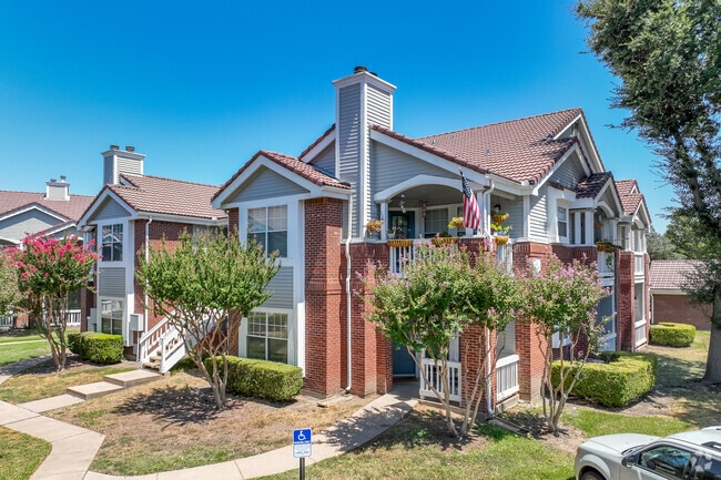

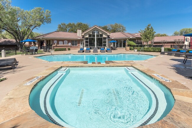
Property Detail
2600 E Renner Rd
R-2029-001-0010-1
CANTERBURY COURT ADDITION, BLK 1, LOT 1
Multifamilydwelling
Collin
MF-M
Texas
B and X Area of moderate flood hazard, usually the area between the limits of the 100-year and 500-year floods.
1
2025
17.49 AC
2025
Plano
032018
Dallas/Ft Worth
228,221 SF
Dallas-Fort Worth-Arlington, TX
NEARBY LISTINGS FOR SALE OR LEASE
DEMOGRAPHICS near 2600 E Renner Rd
1 mile
3 mile
5 mile
2025 Total Population
9,750
107,039
305,497
2030 Population
10,949
117,822
332,092
Pop Growth 2025-2030
+ 12.30%
+ 10.07%
+ 8.71%
Average Age
43
39
39
2025 Total Households
4,272
42,932
111,413
HH Growth 2025-2030
+ 12.69%
+ 10.41%
+ 9.07%
Median Household Inc
$99,136
$92,164
$97,363
Avg Household Size
2.20
2.40
2.60
2025 Avg HH Vehicles
2.00
2.00
2.00
Median Home Value
$463,740
$405,775
$400,484
Median Year Built
1995
1994
1988
Nearby Places
Map Layers
Map Styles
 Street
 Aerial
Transit
 Traffic
 Biking
Places
Listings with unknown addresses are not visible on the map
- Restaurants
- Banks
- Shops
- Fitness
- Groceries
PUBLIC TRANSPORTATION
AIRPORT
Dallas Love Field
Drive
Walk
Distance
Dallas Love Field
30 min
21.6 mi
Dallas-Fort Worth International
Drive
Walk
Distance
Dallas-Fort Worth International
35 min
29.7 mi
Freight Ports
Port of Shreveport
Drive
Walk
Distance
Port of Shreveport
222 min
200.5 mi
Nearby Properties
Address
Land Use
TOTAL SIZE
Lot Size
Zoning
Address
Land Use
TOTAL SIZE
Lot Size
Zoning
1,049,441 SF
Address
Land Use
TOTAL SIZE
Lot Size
Zoning
1,283,376 SF
11.62 AC
Address
Land Use
TOTAL SIZE
Lot Size
Zoning
1,050,550 SF
18.24 AC
Address
Land Use
TOTAL SIZE
Lot Size
Zoning
479,209 SF
19.97 AC
Address
Land Use
TOTAL SIZE
Lot Size
Zoning
453,635 SF
19.04 AC
RT
Address
Land Use
TOTAL SIZE
Lot Size
Zoning
630,247 SF
42 AC
Z239
Address
Land Use
TOTAL SIZE
Lot Size
Zoning
766,245 SF
49.94 AC
COMM
Address
Land Use
TOTAL SIZE
Lot Size
Zoning
567,715 SF
4.75 AC
LC/PD-A
Address
Land Use
TOTAL SIZE
Lot Size
Zoning
1,105,509 SF
92.46 AC
A
Address
Land Use
TOTAL SIZE
Lot Size
Zoning
164,843 SF
24.94 AC
Address
Land Use
TOTAL SIZE
Lot Size
Zoning
242,201 SF
14.54 AC
RT
Address
Land Use
TOTAL SIZE
Lot Size
Zoning
384,538 SF
2.63 AC
LI-1
Address
Land Use
TOTAL SIZE
Lot Size
Zoning
490,285 SF
29.66 AC
LC/PD-A
Address
Land Use
TOTAL SIZE
Lot Size
Zoning
595,150 SF
17.20 AC
MF-H
Address
Land Use
TOTAL SIZE
Lot Size
Zoning
768,061 SF
42.03 AC
Z02
Address
Land Use
TOTAL SIZE
Lot Size
Zoning
341,492 SF
25.20 AC
SFR
Address
Land Use
TOTAL SIZE
Lot Size
Zoning
487,093 SF
6.28 AC
MF-E
Address
Land Use
TOTAL SIZE
Lot Size
Zoning
377,152 SF
3.91 AC
O-S
Address
Land Use
TOTAL SIZE
Lot Size
Zoning
279,693 SF
19.86 AC
Z239
Address
Land Use
TOTAL SIZE
Lot Size
Zoning
548,300 SF
17.29 AC
Z239
Address
Land Use
TOTAL SIZE
Lot Size
Zoning
509,566 SF
34.05 AC
PD
Address
Land Use
TOTAL SIZE
Lot Size
Zoning
324,000 SF
6.67 AC
O-S
Address
Land Use
TOTAL SIZE
Lot Size
Zoning
129,810 SF
14.93 AC
Z236
Address
Land Use
TOTAL SIZE
Lot Size
Zoning
374,266 SF
19.42 AC
Z239
Address
Land Use
TOTAL SIZE
Lot Size
Zoning
795,714 SF
5.36 AC
Z109
Address
Land Use
TOTAL SIZE
Lot Size
Zoning
296,337 SF
3.28 AC
Address
Land Use
TOTAL SIZE
Lot Size
Zoning
360,673 SF
7.89 AC
PD-207 R
Address
Land Use
TOTAL SIZE
Lot Size
Zoning
502,554 SF
31.06 AC
MF-M
Address
Land Use
TOTAL SIZE
Lot Size
Zoning
355,408 SF
3.08 AC
LI-1
Address
Land Use
TOTAL SIZE
Lot Size
Zoning
402,815 SF
5.64 AC
Z236
The World's #1 Commercial Real Estate Marketplace
Connect with us
© 2026 CoStar Group
The information above has been obtained from sources believed reliable. While we do not doubt its accuracy we have not verified it and make no guarantee, warranty or representation about it. It is your responsibility to independently confirm its accuracy and completeness. Any projections, opinions, assumptions, or estimates used are for example only and do not represent the current or future performance of the property. The value of this transaction to you depends on tax and other factors which should be evaluated by your tax, financial, and legal advisors. You and your advisors should conduct a careful, independent investigation of the property to determine to your satisfaction the suitability of the property for your needs.