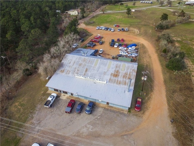
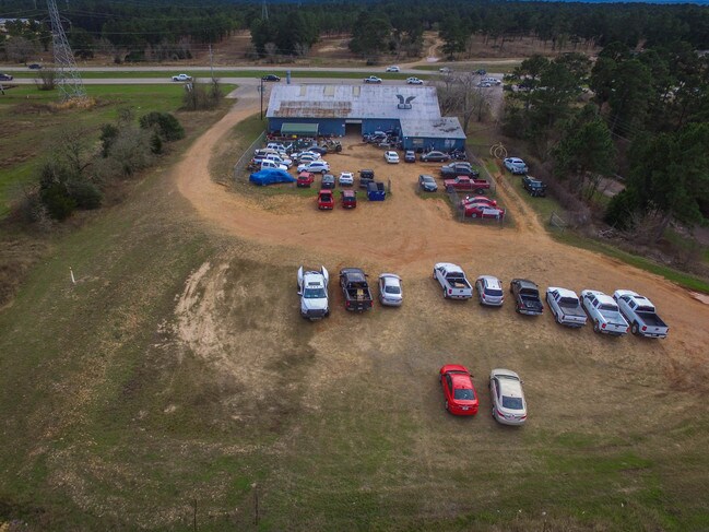
Property Record
2600 E Sh 71 E, Bastrop, TX 78602


Property Detail
2600 E Sh 71 E
64359
A11 BASTROP TOWN TRACT, ACRES 1.6240
Commercialnec
BASTROP
B and X Area of moderate flood hazard, usually the area between the limits of the 100-year and 500-year floods.
Texas
2024
1.62 AC
2025
Bastrop County
950401
Austin
9,520 SF
Austin-Round Rock-San Marcos, TX
NEARBY LISTINGS FOR SALE OR LEASE
-
-
View all Bastrop listings for lease on LoopNet.com
DEMOGRAPHICS near 2600 E Sh 71 E
1 mile
3 mile
5 mile
2024 Total Population
1,987
16,577
27,853
2029 Population
2,467
20,765
34,745
Pop Growth 2024-2029
+ 24.16%
+ 25.26%
+ 24.74%
Average Age
40
41
40
2024 Total Households
827
6,525
10,277
HH Growth 2024-2029
+ 25.15%
+ 26.31%
+ 25.97%
Median Household Inc
$96,314
$90,940
$89,216
Avg Household Size
2.30
2.50
2.60
2024 Avg HH Vehicles
2.00
2.00
2.00
Median Home Value
$230,092
$248,592
$243,354
Median Year Built
1999
2002
2002
Nearby Places
Map Layers
Map Styles
 Street
 Aerial
Transit
 Traffic
 Biking
Places
Listings with unknown addresses are not visible on the map
- Restaurants
- Banks
- Shops
- Fitness
- Groceries
PUBLIC TRANSPORTATION
AIRPORT
Austin-Bergstrom International
Drive
Walk
Distance
Austin-Bergstrom International
40 min
27.7 mi
SALE & LEASE HISTORY
LISTING DATE
SALE/LEASE

Sep 12, 2017
For Sale
May 30, 2018
For Lease
Aug 09, 2017
For Sale
Nearby Properties
Address
Land Use
TOTAL SIZE
Lot Size
Zoning
Address
Land Use
TOTAL SIZE
Lot Size
Zoning
38,112 SF
24.16 AC
Address
Land Use
TOTAL SIZE
Lot Size
Zoning
25.59 AC
Address
Land Use
TOTAL SIZE
Lot Size
Zoning
140,496 SF
8.05 AC
Address
Land Use
TOTAL SIZE
Lot Size
Zoning
140,878 SF
8.31 AC
Address
Land Use
TOTAL SIZE
Lot Size
Zoning
123,176 SF
29.42 AC
Address
Land Use
TOTAL SIZE
Lot Size
Zoning
180,568 SF
23.98 AC
Address
Land Use
TOTAL SIZE
Lot Size
Zoning
105,020 SF
13.43 AC
Address
Land Use
TOTAL SIZE
Lot Size
Zoning
65,206 SF
2.55 AC
Address
Land Use
TOTAL SIZE
Lot Size
Zoning
169,350 SF
25.30 AC
Address
Land Use
TOTAL SIZE
Lot Size
Zoning
121,305 SF
16.06 AC
Address
Land Use
TOTAL SIZE
Lot Size
Zoning
24,788 SF
Address
Land Use
TOTAL SIZE
Lot Size
Zoning
59,941 SF
4.57 AC
Address
Land Use
TOTAL SIZE
Lot Size
Zoning
173,350 SF
10.58 AC
Address
Land Use
TOTAL SIZE
Lot Size
Zoning
133,292 SF
2.67 AC
Address
Land Use
TOTAL SIZE
Lot Size
Zoning
69,508 SF
4.10 AC
Address
Land Use
TOTAL SIZE
Lot Size
Zoning
67,979 SF
4.08 AC
Address
Land Use
TOTAL SIZE
Lot Size
Zoning
47,126 SF
3.33 AC
Address
Land Use
TOTAL SIZE
Lot Size
Zoning
62,734 SF
2.55 AC
Address
Land Use
TOTAL SIZE
Lot Size
Zoning
27,936 SF
5 AC
Address
Land Use
TOTAL SIZE
Lot Size
Zoning
53,318 SF
5.36 AC
Address
Land Use
TOTAL SIZE
Lot Size
Zoning
44,692 SF
2.75 AC
Address
Land Use
TOTAL SIZE
Lot Size
Zoning
17,869 SF
7.71 AC
Address
Land Use
TOTAL SIZE
Lot Size
Zoning
21,610 SF
281.75 AC
Address
Land Use
TOTAL SIZE
Lot Size
Zoning
33,628 SF
3.74 AC
Address
Land Use
TOTAL SIZE
Lot Size
Zoning
28,022 SF
9.19 AC
Address
Land Use
TOTAL SIZE
Lot Size
Zoning
59,561 SF
4.57 AC
Address
Land Use
TOTAL SIZE
Lot Size
Zoning
1,680 SF
43.63 AC
Address
Land Use
TOTAL SIZE
Lot Size
Zoning
31,002 SF
1.56 AC
Address
Land Use
TOTAL SIZE
Lot Size
Zoning
38,351 SF
3.22 AC
Address
Land Use
TOTAL SIZE
Lot Size
Zoning
33,485 SF
1.37 AC
The World's #1 Commercial Real Estate Marketplace
Connect with us
© 2026 CoStar Group
The information above has been obtained from sources believed reliable. While we do not doubt its accuracy we have not verified it and make no guarantee, warranty or representation about it. It is your responsibility to independently confirm its accuracy and completeness. Any projections, opinions, assumptions, or estimates used are for example only and do not represent the current or future performance of the property. The value of this transaction to you depends on tax and other factors which should be evaluated by your tax, financial, and legal advisors. You and your advisors should conduct a careful, independent investigation of the property to determine to your satisfaction the suitability of the property for your needs.