Property Record
2600 E State Street Ext, Trenton, NJ 08619

NEARBY LISTINGS FOR SALE OR LEASE
Property Detail
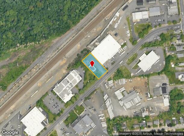
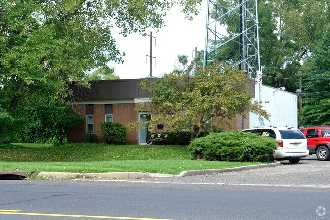
2600 E State Street Ext
03-01588-0000-00011
01515-F
Commercialnec
Mercer
X
New Jersey
34021C0227F
11
2024
0.68 AC
2025
Trenton
002902
Northern New Jersey
3,136 SF
Trenton, NJ
DEMOGRAPHICS near 2600 E State Street Ext
1 Mile
3 Mile
5 Mile
2024 Total Population
5,809
105,158
251,655
2029 Population
5,745
103,400
248,296
Pop Growth 2024-2029
(1.10%)
(1.67%)
(1.33%)
Average Age
42
40
40
2024 Total Households
2,218
38,616
93,045
HH Growth 2024-2029
(1.26%)
(1.73%)
(1.43%)
Median Household Inc
$107,108
$74,427
$75,790
Avg Household Size
2.60
2.60
2.60
2024 Avg HH Vehicles
2.00
2.00
2.00
Median Home Value
$279,999
$248,602
$254,943
Median Year Built
1963
1958
1958
Nearby Places
Map Layers
Map Styles
 Street
 Aerial
- Restaurants
- Banks
- Shops
- Fitness
- Groceries
PUBLIC TRANSPORTATION
COMMUTER RAIL
Hamilton (Northeast Corridor Line - NJ Transit Commuter Rail (NJ Transit))
DRIVE
WALK
Distance
Hamilton (Northeast Corridor Line - NJ Transit Commuter Rail (NJ Transit))
4 min
1.0 mi
Trenton Transit Center (NJT) (Northeast Corridor Line - NJ Transit Commuter Rail (NJ Transit), River LINE - River LINE (River LINE))
DRIVE
WALK
Distance
Trenton Transit Center (NJT) (Northeast Corridor Line - NJ Transit Commuter Rail (NJ Transit), River LINE - River LINE (River LINE))
8 min
3.0 mi
AIRPORT
Trenton Mercer
DRIVE
WALK
Distance
Trenton Mercer
17 min
8.2 mi
Freight Ports
Port of Philadelphia
DRIVE
WALK
Distance
Port of Philadelphia
50 min
32.9 mi
Nearby Properties
Address
Land Use
TOTAL SIZE
Lot Size
Zoning
Address
Land Use
TOTAL SIZE
Lot Size
Zoning
141.90 AC
EGI
Address
Land Use
TOTAL SIZE
Lot Size
Zoning
73.11 AC
RD-2
Address
Land Use
TOTAL SIZE
Lot Size
Zoning
70.44 AC
MX-1
Address
Land Use
TOTAL SIZE
Lot Size
Zoning
5.38 AC
MU
Address
Land Use
TOTAL SIZE
Lot Size
Zoning
Address
Land Use
TOTAL SIZE
Lot Size
Zoning
31.27 AC
LI
Address
Land Use
TOTAL SIZE
Lot Size
Zoning
35.83 AC
RB
Address
Land Use
TOTAL SIZE
Lot Size
Zoning
56.45 AC
EGI
Address
Land Use
TOTAL SIZE
Lot Size
Zoning
24.44 AC
AT
Address
Land Use
TOTAL SIZE
Lot Size
Zoning
161,080 SF
2.21 AC
BA
Address
Land Use
TOTAL SIZE
Lot Size
Zoning
21.19 AC
B-H
Address
Land Use
TOTAL SIZE
Lot Size
Zoning
Address
Land Use
TOTAL SIZE
Lot Size
Zoning
44.83 AC
I
Address
Land Use
TOTAL SIZE
Lot Size
Zoning
10.29 AC
RB
Address
Land Use
TOTAL SIZE
Lot Size
Zoning
69.56 AC
EGI
Address
Land Use
TOTAL SIZE
Lot Size
Zoning
21.17 AC
I
Address
Land Use
TOTAL SIZE
Lot Size
Zoning
4.07 AC
MU
Address
Land Use
TOTAL SIZE
Lot Size
Zoning
16.86 AC
EG1
Address
Land Use
TOTAL SIZE
Lot Size
Zoning
16.45 AC
I-2
Address
Land Use
TOTAL SIZE
Lot Size
Zoning
27.50 AC
R7
Address
Land Use
TOTAL SIZE
Lot Size
Zoning
Address
Land Use
TOTAL SIZE
Lot Size
Zoning
75,000 SF
3.08 AC
BH
Address
Land Use
TOTAL SIZE
Lot Size
Zoning
82,244 SF
5.35 AC
IA
Address
Land Use
TOTAL SIZE
Lot Size
Zoning
47.84 AC
HC
Address
Land Use
TOTAL SIZE
Lot Size
Zoning
5 AC
RM
Address
Land Use
TOTAL SIZE
Lot Size
Zoning
157,952 SF
0.80 AC
BB
Address
Land Use
TOTAL SIZE
Lot Size
Zoning
45,175 SF
6.04 AC
PRO
Address
Land Use
TOTAL SIZE
Lot Size
Zoning
173,385 SF
1.78 AC
MU
Address
Land Use
TOTAL SIZE
Lot Size
Zoning
21.31 AC
RD-2
Address
Land Use
TOTAL SIZE
Lot Size
Zoning
156,128 SF
6.33 AC
RB
The World's #1 Commercial Real Estate Marketplace
Connect with us
© 2025 CoStar Group
The information above has been obtained from sources believed reliable. While we do not doubt its accuracy we have not verified it and make no guarantee, warranty or representation about it. It is your responsibility to independently confirm its accuracy and completeness. Any projections, opinions, assumptions, or estimates used are for example only and do not represent the current or future performance of the property. The value of this transaction to you depends on tax and other factors which should be evaluated by your tax, financial, and legal advisors. You and your advisors should conduct a careful, independent investigation of the property to determine to your satisfaction the suitability of the property for your needs.