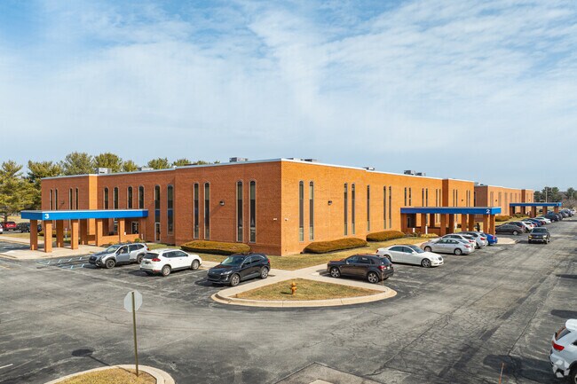
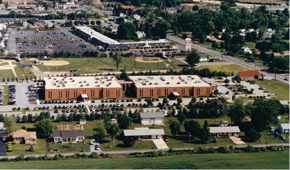
Property Record
2600 Glasgow Ave, Newark, DE 19702

Current Lease Availabilities
Property Detail
2600 Glasgow Ave
11-026.00-115
BEG AT POINT IN SWLY SIDE OF DELAWARE ST ROUTE NO 896
Medicalbuilding
New Castle
ON
Delaware
B and X Area of moderate flood hazard, usually the area between the limits of the 100-year and 500-year floods.
11.72 AC
2025
South New Castle County
2025
Philadelphia
014812
Philadelphia-Camden-Wilmington, PA-NJ-DE-MD
55,200 SF
NEARBY LISTINGS FOR SALE OR LEASE
DEMOGRAPHICS near 2600 Glasgow Ave
1 mile
3 mile
5 mile
2025 Total Population
4,099
43,258
111,494
2030 Population
4,209
44,295
114,009
Pop Growth 2025-2030
+ 2.68%
+ 2.40%
+ 2.26%
Average Age
43
40
40
2025 Total Households
1,479
16,005
41,346
HH Growth 2025-2030
+ 2.84%
+ 2.53%
+ 2.38%
Median Household Inc
$130,357
$103,561
$93,780
Avg Household Size
2.70
2.70
2.60
2025 Avg HH Vehicles
2.00
2.00
2.00
Median Home Value
$412,527
$381,378
$356,051
Median Year Built
1989
1993
1992
Nearby Places
Map Layers
Map Styles
 Street
 Aerial
Layers
 Traffic
 Biking
Places
Listings with unknown addresses are not visible on the map
- Restaurants
- Banks
- Shops
- Fitness
- Groceries
PUBLIC TRANSPORTATION
COMMUTER RAIL
Newark (R2 - Southeastern Pennsylvania Transportation Authority Regional Rail (SEPTA Regional Rail))
Drive
Walk
Distance
Newark (R2 - Southeastern Pennsylvania Transportation Authority Regional Rail (SEPTA Regional Rail))
8 min
5.4 mi
Churchmans Crossing (R2 - Southeastern Pennsylvania Transportation Authority Regional Rail (SEPTA Regional Rail))
Drive
Walk
Distance
Churchmans Crossing (R2 - Southeastern Pennsylvania Transportation Authority Regional Rail (SEPTA Regional Rail))
16 min
9.9 mi
Freight Ports
Port of Wilmington, RI
Drive
Walk
Distance
Port of Wilmington, RI
25 min
17.3 mi
Nearby Properties
Address
Land Use
TOTAL SIZE
Lot Size
Zoning
Address
Land Use
TOTAL SIZE
Lot Size
Zoning
226,878 SF
73.68 AC
CR
Address
Land Use
TOTAL SIZE
Lot Size
Zoning
161,018 SF
97.88 AC
OR
Address
Land Use
TOTAL SIZE
Lot Size
Zoning
59.70 AC
BP
Address
Land Use
TOTAL SIZE
Lot Size
Zoning
343,216 SF
27.10 AC
ST
Address
Land Use
TOTAL SIZE
Lot Size
Zoning
200,880 SF
49.83 AC
R3
Address
Land Use
TOTAL SIZE
Lot Size
Zoning
385,350 SF
43.51 AC
OR
Address
Land Use
TOTAL SIZE
Lot Size
Zoning
266,818 SF
64.16 AC
BP
Address
Land Use
TOTAL SIZE
Lot Size
Zoning
293,376 SF
149.74 AC
I
Address
Land Use
TOTAL SIZE
Lot Size
Zoning
281.01 AC
BP
Address
Land Use
TOTAL SIZE
Lot Size
Zoning
930 SF
52.69 AC
S
Address
Land Use
TOTAL SIZE
Lot Size
Zoning
15,168 SF
7.85 AC
NCAP
Address
Land Use
TOTAL SIZE
Lot Size
Zoning
392,955 SF
16.87 AC
NCAP
Address
Land Use
TOTAL SIZE
Lot Size
Zoning
20,250 SF
71.16 AC
S
Address
Land Use
TOTAL SIZE
Lot Size
Zoning
18,101 SF
8.91 AC
NCAP
Address
Land Use
TOTAL SIZE
Lot Size
Zoning
263,500 SF
15.28 AC
BI
Address
Land Use
TOTAL SIZE
Lot Size
Zoning
91,473 SF
59.44 AC
S
Address
Land Use
TOTAL SIZE
Lot Size
Zoning
82,688 SF
11.30 AC
BI
Address
Land Use
TOTAL SIZE
Lot Size
Zoning
267,840 SF
20.35 AC
BI
Address
Land Use
TOTAL SIZE
Lot Size
Zoning
47.77 AC
OR
Address
Land Use
TOTAL SIZE
Lot Size
Zoning
153,556 SF
30.12 AC
OR
Address
Land Use
TOTAL SIZE
Lot Size
Zoning
3,680 SF
138.68 AC
S
Address
Land Use
TOTAL SIZE
Lot Size
Zoning
132,816 SF
7.11 AC
NCPUD
Address
Land Use
TOTAL SIZE
Lot Size
Zoning
145.78 AC
BP
Address
Land Use
TOTAL SIZE
Lot Size
Zoning
5,166 SF
7.57 AC
NCAP
Address
Land Use
TOTAL SIZE
Lot Size
Zoning
205,955 SF
24.91 AC
BI
Address
Land Use
TOTAL SIZE
Lot Size
Zoning
165,961 SF
8.95 AC
BP
Address
Land Use
TOTAL SIZE
Lot Size
Zoning
11,671 SF
27.80 AC
ST
Address
Land Use
TOTAL SIZE
Lot Size
Zoning
9,660 SF
16.90 AC
BP
Address
Land Use
TOTAL SIZE
Lot Size
Zoning
18,415 SF
23.33 AC
OR
The World's #1 Commercial Real Estate Marketplace
Connect with us
© 2026 CoStar Group
The information above has been obtained from sources believed reliable. While we do not doubt its accuracy we have not verified it and make no guarantee, warranty or representation about it. It is your responsibility to independently confirm its accuracy and completeness. Any projections, opinions, assumptions, or estimates used are for example only and do not represent the current or future performance of the property. The value of this transaction to you depends on tax and other factors which should be evaluated by your tax, financial, and legal advisors. You and your advisors should conduct a careful, independent investigation of the property to determine to your satisfaction the suitability of the property for your needs.