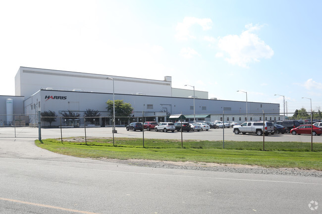
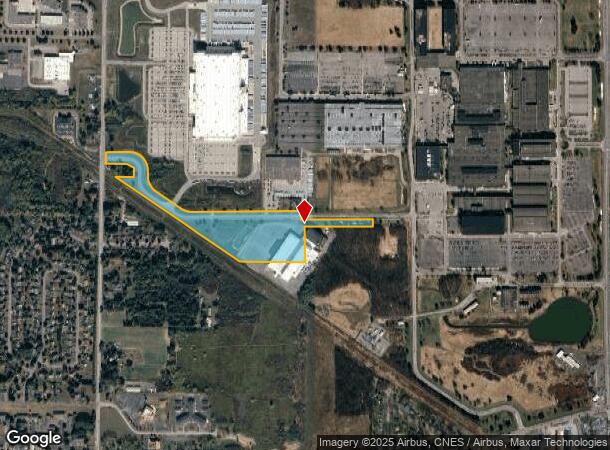
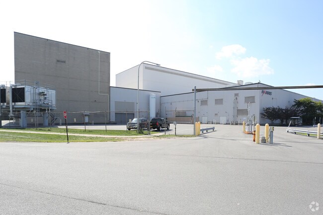
Property Record
2600 Manitou Rd, Rochester, NY 14624
NEARBY LISTINGS FOR SALE OR LEASE
Property Detail
2600 Manitou Rd
262600-118-090-0001-025-000
L157 & 158 TWP 1 SHT RNG EASTMAN KODAK SUB. BLDG.101 L304P57 6/14/00
Manufacturinglight
Monroe
X
New York
36055C0188G
25.000
2025
20.26 AC
2024
Southwest
014202
Rochester
82,727 SF
Rochester, NY
DEMOGRAPHICS near 2600 Manitou Rd
1 Mile
3 Mile
5 Mile
2024 Total Population
4,027
42,380
100,822
2029 Population
4,027
41,751
99,274
Pop Growth 2024-2029
0.00%
(1.48%)
(1.54%)
Average Age
42
43
42
2024 Total Households
1,788
17,818
42,210
HH Growth 2024-2029
(0.34%)
(1.62%)
(1.63%)
Median Household Inc
$69,446
$74,104
$69,548
Avg Household Size
2.20
2.30
2.30
2024 Avg HH Vehicles
2.00
2.00
2.00
Median Home Value
$178,775
$159,000
$156,862
Median Year Built
1985
1972
1969
Nearby Places
Map Layers
Map Styles
 Street
 Aerial
- Restaurants
- Banks
- Shops
- Fitness
- Groceries
PUBLIC TRANSPORTATION
COMMUTER RAIL
Rochester (Empire Service - VIA Rail, Lake Shore Limited - VIA Rail, Maple Leaf - VIA Rail, Toronto - New York - VIA Rail)
DRIVE
WALK
Distance
Rochester (Empire Service - VIA Rail, Lake Shore Limited - VIA Rail, Maple Leaf - VIA Rail, Toronto - New York - VIA Rail)
15 min
8.4 mi
AIRPORT
Frederick Douglass/Greater Rochester International
DRIVE
WALK
Distance
Frederick Douglass/Greater Rochester International
14 min
8.3 mi
Freight Ports
Albany, NY Port
DRIVE
WALK
Distance
Albany, NY Port
280 min
234.5 mi
Nearby Properties
Address
Land Use
TOTAL SIZE
Lot Size
Zoning
Address
Land Use
TOTAL SIZE
Lot Size
Zoning
796,051 SF
100.85 AC
06 - INDUS
Address
Land Use
TOTAL SIZE
Lot Size
Zoning
348,895 SF
76.07 AC
06 - INDUS
Address
Land Use
TOTAL SIZE
Lot Size
Zoning
11,408 SF
98.28 AC
02 - SINGL
Address
Land Use
TOTAL SIZE
Lot Size
Zoning
280,300 SF
71.39 AC
LI
Address
Land Use
TOTAL SIZE
Lot Size
Zoning
279,852 SF
78.40 AC
R-1
Address
Land Use
TOTAL SIZE
Lot Size
Zoning
671,599 SF
33.10 AC
06 - INDUS
Address
Land Use
TOTAL SIZE
Lot Size
Zoning
109,772 SF
10.42 AC
06 - INDUS
Address
Land Use
TOTAL SIZE
Lot Size
Zoning
14,268 SF
36.20 AC
MFR
Address
Land Use
TOTAL SIZE
Lot Size
Zoning
149,541 SF
6.10 AC
03 - MULTI
Address
Land Use
TOTAL SIZE
Lot Size
Zoning
6,960 SF
20.31 AC
02 - SINGL
Address
Land Use
TOTAL SIZE
Lot Size
Zoning
119,706 SF
16.43 AC
05 - COMME
Address
Land Use
TOTAL SIZE
Lot Size
Zoning
23,940 SF
6.45 AC
05 - COMME
Address
Land Use
TOTAL SIZE
Lot Size
Zoning
87,106 SF
8.66 AC
SC
Address
Land Use
TOTAL SIZE
Lot Size
Zoning
9,556 SF
21.24 AC
MFR
Address
Land Use
TOTAL SIZE
Lot Size
Zoning
4,448 SF
18.78 AC
05 - COMME
Address
Land Use
TOTAL SIZE
Lot Size
Zoning
186,687 SF
13.90 AC
LI
Address
Land Use
TOTAL SIZE
Lot Size
Zoning
62,915 SF
6.77 AC
02 - SINGL
Address
Land Use
TOTAL SIZE
Lot Size
Zoning
0.91 AC
06 - INDUS
Address
Land Use
TOTAL SIZE
Lot Size
Zoning
56,848 SF
28.90 AC
06 - INDUS
Address
Land Use
TOTAL SIZE
Lot Size
Zoning
128,938 SF
36.11 AC
06 - INDUS
Address
Land Use
TOTAL SIZE
Lot Size
Zoning
116,193 SF
12.23 AC
05 - COMME
Address
Land Use
TOTAL SIZE
Lot Size
Zoning
83,632 SF
3.48 AC
02 - SINGL
Address
Land Use
TOTAL SIZE
Lot Size
Zoning
85,932 SF
4.70 AC
05 - COMME
Address
Land Use
TOTAL SIZE
Lot Size
Zoning
143,325 SF
12.20 AC
LI
Address
Land Use
TOTAL SIZE
Lot Size
Zoning
11,200 SF
5.67 AC
06 - INDUS
Address
Land Use
TOTAL SIZE
Lot Size
Zoning
161,045 SF
24.37 AC
05 - COMME
Address
Land Use
TOTAL SIZE
Lot Size
Zoning
223,866 SF
13.43 AC
06 - INDUS
Address
Land Use
TOTAL SIZE
Lot Size
Zoning
310,275 SF
16.91 AC
06 - INDUS
Address
Land Use
TOTAL SIZE
Lot Size
Zoning
3,640 SF
20.41 AC
03 - MULTI
Address
Land Use
TOTAL SIZE
Lot Size
Zoning
54,097 SF
10.40 AC
02 - SINGL
The World's #1 Commercial Real Estate Marketplace
Connect with us
© 2025 CoStar Group
The information above has been obtained from sources believed reliable. While we do not doubt its accuracy we have not verified it and make no guarantee, warranty or representation about it. It is your responsibility to independently confirm its accuracy and completeness. Any projections, opinions, assumptions, or estimates used are for example only and do not represent the current or future performance of the property. The value of this transaction to you depends on tax and other factors which should be evaluated by your tax, financial, and legal advisors. You and your advisors should conduct a careful, independent investigation of the property to determine to your satisfaction the suitability of the property for your needs.