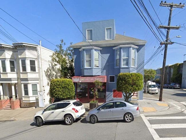
Property Record
2600 Mcallister St, San Francisco, CA 94118


Current Lease Availabilities
NEARBY LISTINGS FOR SALE OR LEASE
Property Detail
2600 Mcallister St
San Francisco-Redwood City-South San Francisco, CA
San Francisco
1166-003
California
Retailwithmorethanonenonretailuse
3
2024
0.08 AC
2025
West of Van Ness
015600
San Francisco
4,164 SF
DEMOGRAPHICS near 2600 Mcallister St
1 Mile
3 Mile
5 Mile
2024 Total Population
68,763
509,524
782,026
2029 Population
63,922
473,067
723,162
Pop Growth 2024-2029
(7.04%)
(7.16%)
(7.53%)
Average Age
40
43
43
2024 Total Households
29,638
234,223
333,722
HH Growth 2024-2029
(7.61%)
(7.67%)
(7.86%)
Median Household Inc
$152,728
$127,935
$127,017
Avg Household Size
2.20
2.00
2.20
2024 Avg HH Vehicles
1.00
1.00
1.00
Median Home Value
$1,111,233
$1,111,335
$1,100,127
Median Year Built
1946
1948
1949
Nearby Places
Map Layers
Map Styles
 Street
 Aerial
- Restaurants
- Banks
- Shops
- Fitness
- Groceries
PUBLIC TRANSPORTATION
TRANSIT/SUBWAY
Carl and Stanyan (N Judah - San Francisco Municipal Railway (MUNI Metro))
DRIVE
WALK
Distance
Carl and Stanyan (N Judah - San Francisco Municipal Railway (MUNI Metro))
2 min
14 min
0.7 mi
Carl and Cole (N Judah - San Francisco Municipal Railway (MUNI Metro))
DRIVE
WALK
Distance
Carl and Cole (N Judah - San Francisco Municipal Railway (MUNI Metro))
2 min
17 min
0.9 mi
Carl Street and Hillway Avenue (N Judah - San Francisco Municipal Railway (MUNI Metro))
DRIVE
WALK
Distance
Carl Street and Hillway Avenue (N Judah - San Francisco Municipal Railway (MUNI Metro))
3 min
18 min
0.9 mi
UCSF (N Judah - San Francisco Municipal Railway (MUNI Metro))
DRIVE
WALK
Distance
UCSF (N Judah - San Francisco Municipal Railway (MUNI Metro))
3 min
19 min
1.0 mi
Irving and 4th Avenue (N Judah - San Francisco Municipal Railway (MUNI Metro))
DRIVE
WALK
Distance
Irving and 4th Avenue (N Judah - San Francisco Municipal Railway (MUNI Metro))
3 min
20 min
1.0 mi
COMMUTER RAIL
San Francisco 4th & King (Caltrain - Caltrain (Caltrain))
DRIVE
WALK
Distance
San Francisco 4th & King (Caltrain - Caltrain (Caltrain))
10 min
4.5 mi
DRIVE
WALK
Distance
10 min
4.5 mi
AIRPORT
San Francisco International
DRIVE
WALK
Distance
San Francisco International
27 min
15.4 mi
Metro Oakland International
DRIVE
WALK
Distance
Metro Oakland International
38 min
22.9 mi
Norman Y Mineta San Jose International
DRIVE
WALK
Distance
Norman Y Mineta San Jose International
62 min
47.1 mi
Freight Ports
Port of San Francisco
DRIVE
WALK
Distance
Port of San Francisco
11 min
4.6 mi
Nearby Properties
Address
Land Use
TOTAL SIZE
Lot Size
Zoning
Address
Land Use
TOTAL SIZE
Lot Size
Zoning
1,015,000 SF
2.43 AC
RC4
Address
Land Use
TOTAL SIZE
Lot Size
Zoning
248,303 SF
4.35 AC
Address
Land Use
TOTAL SIZE
Lot Size
Zoning
717,234 SF
3.47 AC
UMU
Address
Land Use
TOTAL SIZE
Lot Size
Zoning
266,143 SF
4 AC
C-3-R
Address
Land Use
TOTAL SIZE
Lot Size
Zoning
508,714 SF
1.29 AC
C3R
Address
Land Use
TOTAL SIZE
Lot Size
Zoning
696,431 SF
0.97 AC
C3G
Address
Land Use
TOTAL SIZE
Lot Size
Zoning
139,070 SF
0.64 AC
C3O
Address
Land Use
TOTAL SIZE
Lot Size
Zoning
1.52 AC
C3G
Address
Land Use
TOTAL SIZE
Lot Size
Zoning
1,424,230 SF
2.60 AC
C3G
Address
Land Use
TOTAL SIZE
Lot Size
Zoning
263,640 SF
0.72 AC
C3R
Address
Land Use
TOTAL SIZE
Lot Size
Zoning
313,306 SF
1.23 AC
WMUG
Address
Land Use
TOTAL SIZE
Lot Size
Zoning
922,758 SF
1.94 AC
C3R
Address
Land Use
TOTAL SIZE
Lot Size
Zoning
461,138 SF
0.60 AC
C3O
Address
Land Use
TOTAL SIZE
Lot Size
Zoning
393,918 SF
3.36 AC
WMUG
Address
Land Use
TOTAL SIZE
Lot Size
Zoning
403,629 SF
0.73 AC
C3O
Address
Land Use
TOTAL SIZE
Lot Size
Zoning
24.37 AC
Address
Land Use
TOTAL SIZE
Lot Size
Zoning
674,317 SF
3.36 AC
UMU
Address
Land Use
TOTAL SIZE
Lot Size
Zoning
649,376 SF
0.93 AC
C3S
Address
Land Use
TOTAL SIZE
Lot Size
Zoning
2.93 AC
Address
Land Use
TOTAL SIZE
Lot Size
Zoning
342,727 SF
1.36 AC
C3G
Address
Land Use
TOTAL SIZE
Lot Size
Zoning
291,522 SF
6.66 AC
CM
Address
Land Use
TOTAL SIZE
Lot Size
Zoning
488,882 SF
0.53 AC
C3O
Address
Land Use
TOTAL SIZE
Lot Size
Zoning
610,645 SF
0.82 AC
C3R
Address
Land Use
TOTAL SIZE
Lot Size
Zoning
718 SF
18.55 AC
RH2
Address
Land Use
TOTAL SIZE
Lot Size
Zoning
243,612 SF
1.94 AC
Address
Land Use
TOTAL SIZE
Lot Size
Zoning
345,000 SF
1.74 AC
WMUG
Address
Land Use
TOTAL SIZE
Lot Size
Zoning
420,654 SF
1.82 AC
C3G
Address
Land Use
TOTAL SIZE
Lot Size
Zoning
804,136 SF
2.60 AC
RM4
Address
Land Use
TOTAL SIZE
Lot Size
Zoning
564,614 SF
0.90 AC
C3S
Address
Land Use
TOTAL SIZE
Lot Size
Zoning
246,069 SF
0.69 AC
The World's #1 Commercial Real Estate Marketplace
Connect with us
© 2025 CoStar Group
The information above has been obtained from sources believed reliable. While we do not doubt its accuracy we have not verified it and make no guarantee, warranty or representation about it. It is your responsibility to independently confirm its accuracy and completeness. Any projections, opinions, assumptions, or estimates used are for example only and do not represent the current or future performance of the property. The value of this transaction to you depends on tax and other factors which should be evaluated by your tax, financial, and legal advisors. You and your advisors should conduct a careful, independent investigation of the property to determine to your satisfaction the suitability of the property for your needs.