Property Record
2600 Midway Branch Dr, Odenton, MD 21113
NEARBY LISTINGS FOR SALE OR LEASE
-
-
View all Odenton listings for sale on LoopNet.com
Property Detail
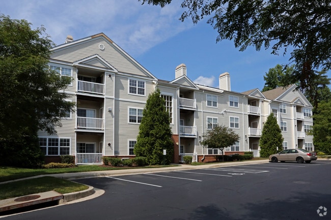
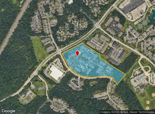
2600 Midway Branch Dr
04-571-90097503
Riverscape/Piney Orchard
Nightclub
16.232 ACRES RIVERSCAPE/PINEY ORCHARD
X
Anne Arundel
24033C0090E
Maryland
2024
16.23 AC
2025
Odenton
740704
Baltimore
296,453 SF
Baltimore-Columbia-Towson, MD
DEMOGRAPHICS near 2600 Midway Branch Dr
1 Mile
3 Mile
5 Mile
2024 Total Population
8,616
42,336
124,955
2029 Population
8,801
43,725
127,942
Pop Growth 2024-2029
+ 2.15%
+ 3.28%
+ 2.39%
Average Age
39
38
37
2024 Total Households
3,728
17,174
45,469
HH Growth 2024-2029
+ 2.23%
+ 3.49%
+ 2.62%
Median Household Inc
$111,041
$110,709
$115,894
Avg Household Size
2.30
2.40
2.60
2024 Avg HH Vehicles
2.00
2.00
2.00
Median Home Value
$357,745
$392,116
$416,765
Median Year Built
1998
2000
1994
Nearby Places
- Restaurants
- Banks
- Shops
- Fitness
- Groceries
PUBLIC TRANSPORTATION
COMMUTER RAIL
Odenton (PENN - WASHINGTON - Maryland Area Regional Commuter Trains (The MARC), Penn Line - Maryland Area Regional Commuter Trains (The MARC))
DRIVE
WALK
Distance
Odenton (PENN - WASHINGTON - Maryland Area Regional Commuter Trains (The MARC), Penn Line - Maryland Area Regional Commuter Trains (The MARC))
6 min
2.6 mi
AIRPORT
Baltimore/Washington International Thurgood Marshall
DRIVE
WALK
Distance
Baltimore/Washington International Thurgood Marshall
21 min
10.9 mi
Ronald Reagan Washington Ntl
DRIVE
WALK
Distance
Ronald Reagan Washington Ntl
51 min
32.2 mi
Freight Ports
Port of Baltimore
DRIVE
WALK
Distance
Port of Baltimore
35 min
20.7 mi
Nearby Properties
Address
Land Use
TOTAL SIZE
Lot Size
Zoning
Address
Land Use
TOTAL SIZE
Lot Size
Zoning
472,057 SF
15.16 AC
OCOR
Address
Land Use
TOTAL SIZE
Lot Size
Zoning
155,020 SF
19.86 AC
R22
Address
Land Use
TOTAL SIZE
Lot Size
Zoning
360,354 SF
7.36 AC
MXD-C
Address
Land Use
TOTAL SIZE
Lot Size
Zoning
432,928 SF
6.33 AC
O-COR
Address
Land Use
TOTAL SIZE
Lot Size
Zoning
88,272 SF
3.43 AC
OTRA
Address
Land Use
TOTAL SIZE
Lot Size
Zoning
279,318 SF
14.38 AC
R22
Address
Land Use
TOTAL SIZE
Lot Size
Zoning
246,000 SF
15.73 AC
MXDR
Address
Land Use
TOTAL SIZE
Lot Size
Zoning
273,816 SF
44.22 AC
MXD-C
Address
Land Use
TOTAL SIZE
Lot Size
Zoning
14.65 AC
R15
Address
Land Use
TOTAL SIZE
Lot Size
Zoning
255,561 SF
15.93 AC
R22
Address
Land Use
TOTAL SIZE
Lot Size
Zoning
499,471 SF
10.10 AC
O-COR
Address
Land Use
TOTAL SIZE
Lot Size
Zoning
311,870 SF
10.03 AC
Address
Land Use
TOTAL SIZE
Lot Size
Zoning
230,204 SF
6.74 AC
O COR
Address
Land Use
TOTAL SIZE
Lot Size
Zoning
237,377 SF
9.86 AC
R15
Address
Land Use
TOTAL SIZE
Lot Size
Zoning
265,645 SF
12.79 AC
R15
Address
Land Use
TOTAL SIZE
Lot Size
Zoning
125.95 AC
R5
Address
Land Use
TOTAL SIZE
Lot Size
Zoning
185,440 SF
3.53 AC
W2
Address
Land Use
TOTAL SIZE
Lot Size
Zoning
155,269 SF
13.27 AC
O-EOD
Address
Land Use
TOTAL SIZE
Lot Size
Zoning
342,464 SF
22.95 AC
O-IND
Address
Land Use
TOTAL SIZE
Lot Size
Zoning
72,925 SF
4.12 AC
MXR
Address
Land Use
TOTAL SIZE
Lot Size
Zoning
37,320 SF
18.76 AC
O-COR
Address
Land Use
TOTAL SIZE
Lot Size
Zoning
117,156 SF
3.70 AC
O-NOD
Address
Land Use
TOTAL SIZE
Lot Size
Zoning
10.95 AC
O-EOD
Address
Land Use
TOTAL SIZE
Lot Size
Zoning
111,617 SF
11.87 AC
O-NOD
Address
Land Use
TOTAL SIZE
Lot Size
Zoning
47,744 SF
1.79 AC
MXD-C
Address
Land Use
TOTAL SIZE
Lot Size
Zoning
134,923 SF
8.35 AC
MXD-C
Address
Land Use
TOTAL SIZE
Lot Size
Zoning
86,496 SF
6.86 AC
R5
Address
Land Use
TOTAL SIZE
Lot Size
Zoning
112,028 SF
40.41 AC
R1
Address
Land Use
TOTAL SIZE
Lot Size
Zoning
63,000 SF
22.90 AC
R1
The World's #1 Commercial Real Estate Marketplace
Connect with us
© 2025 CoStar Group
The information above has been obtained from sources believed reliable. While we do not doubt its accuracy we have not verified it and make no guarantee, warranty or representation about it. It is your responsibility to independently confirm its accuracy and completeness. Any projections, opinions, assumptions, or estimates used are for example only and do not represent the current or future performance of the property. The value of this transaction to you depends on tax and other factors which should be evaluated by your tax, financial, and legal advisors. You and your advisors should conduct a careful, independent investigation of the property to determine to your satisfaction the suitability of the property for your needs.