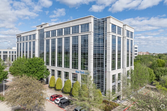
Property Record
2600 Network Blvd, Frisco, TX 75034

Property Detail
2600 Network Blvd
Dallas-Fort Worth-Arlington, TX
HALL OFFICE PARK PHASE B2, BLK A, LOT 1
R-8673-00A-0010-1
COLLIN
Officebuilding
Texas
AE The base floodplain where base flood elevations are provided. AE Zones are now used on new format FIRMs instead of A1-A30 Zones.
1
2025
8.93 AC
2025
Frisco/The Colony
030504
Dallas/Ft Worth
151,400 SF
NEARBY LISTINGS FOR SALE OR LEASE
DEMOGRAPHICS near 2600 Network Blvd
1 mile
3 mile
5 mile
2025 Total Population
9,677
110,249
326,702
2030 Population
11,280
125,176
369,586
Pop Growth 2025-2030
+ 16.57%
+ 13.54%
+ 13.13%
Average Age
37
38
39
2025 Total Households
5,696
45,739
126,645
HH Growth 2025-2030
+ 16.94%
+ 14.04%
+ 13.50%
Median Household Inc
$99,273
$115,502
$126,610
Avg Household Size
1.70
2.40
2.50
2025 Avg HH Vehicles
1.00
2.00
2.00
Median Home Value
$863,763
$655,588
$632,038
Median Year Built
2010
2005
2002
Nearby Places
Map Layers
Map Styles
 Street
 Aerial
Transit
 Traffic
 Biking
Places
Listings with unknown addresses are not visible on the map
- Restaurants
- Banks
- Shops
- Fitness
- Groceries
PUBLIC TRANSPORTATION
AIRPORT
Dallas Love Field
Drive
Walk
Distance
Dallas Love Field
29 min
21.5 mi
Dallas-Fort Worth International
Drive
Walk
Distance
Dallas-Fort Worth International
28 min
22.4 mi
SALE & LEASE HISTORY
LISTING DATE
SALE/LEASE

Sep 25, 2016
For Lease
Oct 03, 2016
For Lease
May 21, 2025
For Lease
May 16, 2017
For Lease
Feb 20, 2018
For Lease
Nearby Properties
Address
Land Use
TOTAL SIZE
Lot Size
Zoning
Address
Land Use
TOTAL SIZE
Lot Size
Zoning
1,622,342 SF
48.59 AC
Address
Land Use
TOTAL SIZE
Lot Size
Zoning
1,508,248 SF
49.26 AC
CE
Address
Land Use
TOTAL SIZE
Lot Size
Zoning
779,629 SF
56 AC
Address
Land Use
TOTAL SIZE
Lot Size
Zoning
958,318 SF
9.07 AC
CE
Address
Land Use
TOTAL SIZE
Lot Size
Zoning
1,316,483 SF
47.52 AC
Address
Land Use
TOTAL SIZE
Lot Size
Zoning
1,929,059 SF
55.12 AC
CE
Address
Land Use
TOTAL SIZE
Lot Size
Zoning
558,664 SF
20.14 AC
CE
Address
Land Use
TOTAL SIZE
Lot Size
Zoning
525,388 SF
5.01 AC
Address
Land Use
TOTAL SIZE
Lot Size
Zoning
358,447 SF
40.21 AC
Address
Land Use
TOTAL SIZE
Lot Size
Zoning
975,081 SF
15.33 AC
Address
Land Use
TOTAL SIZE
Lot Size
Zoning
525,405 SF
5.09 AC
Address
Land Use
TOTAL SIZE
Lot Size
Zoning
741,280 SF
90.87 AC
Address
Land Use
TOTAL SIZE
Lot Size
Zoning
4,575,402 SF
51.93 AC
Address
Land Use
TOTAL SIZE
Lot Size
Zoning
725,987 SF
34.18 AC
CE
Address
Land Use
TOTAL SIZE
Lot Size
Zoning
420,131 SF
3.92 AC
COMM
Address
Land Use
TOTAL SIZE
Lot Size
Zoning
426,009 SF
3.60 AC
Address
Land Use
TOTAL SIZE
Lot Size
Zoning
358,496 SF
2.49 AC
Address
Land Use
TOTAL SIZE
Lot Size
Zoning
426,009 SF
3.60 AC
Address
Land Use
TOTAL SIZE
Lot Size
Zoning
325,179 SF
4.74 AC
COMM
Address
Land Use
TOTAL SIZE
Lot Size
Zoning
440,034 SF
2.11 AC
CE
Address
Land Use
TOTAL SIZE
Lot Size
Zoning
455,432 SF
2.55 AC
MULTI-FAMI
Address
Land Use
TOTAL SIZE
Lot Size
Zoning
356,196 SF
3.71 AC
CB-1
Address
Land Use
TOTAL SIZE
Lot Size
Zoning
337,550 SF
8.73 AC
Address
Land Use
TOTAL SIZE
Lot Size
Zoning
584,998 SF
23.45 AC
Address
Land Use
TOTAL SIZE
Lot Size
Zoning
333,321 SF
5.80 AC
CE
Address
Land Use
TOTAL SIZE
Lot Size
Zoning
318,230 SF
5.52 AC
Address
Land Use
TOTAL SIZE
Lot Size
Zoning
761,346 SF
75.86 AC
Address
Land Use
TOTAL SIZE
Lot Size
Zoning
320,098 SF
20 AC
CE
Address
Land Use
TOTAL SIZE
Lot Size
Zoning
375,848 SF
5.76 AC
Address
Land Use
TOTAL SIZE
Lot Size
Zoning
1,578,500 SF
91.04 AC
The World's #1 Commercial Real Estate Marketplace
Connect with us
© 2026 CoStar Group
The information above has been obtained from sources believed reliable. While we do not doubt its accuracy we have not verified it and make no guarantee, warranty or representation about it. It is your responsibility to independently confirm its accuracy and completeness. Any projections, opinions, assumptions, or estimates used are for example only and do not represent the current or future performance of the property. The value of this transaction to you depends on tax and other factors which should be evaluated by your tax, financial, and legal advisors. You and your advisors should conduct a careful, independent investigation of the property to determine to your satisfaction the suitability of the property for your needs.