Property Record
2600 Nodular Dr, Saginaw, MI 48601

NEARBY LISTINGS FOR SALE OR LEASE
Property Detail
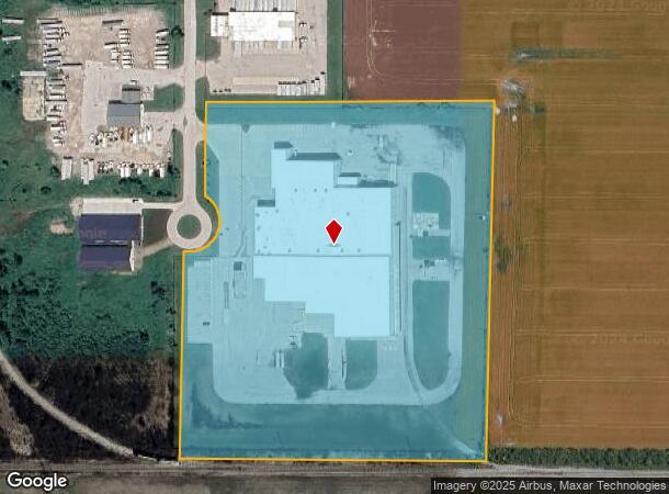
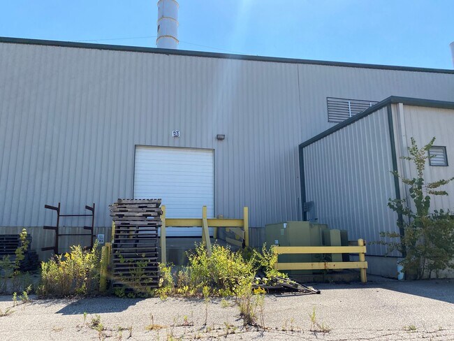
2600 Nodular Dr
10125161002010
COM AT N 1/4 CORN OF SEC TH S 1969.02 FT TH E 600.01 FT TH N 138 FT TH E 80 FT TO POB OF THIS DESC TH N 92.78 FT TH E 748.42 FT TH S 903.45 FT TO N LINE OF CSX RR R/W TH W 812.11 FT TH N 524.42 FT TH NELY ALONG THE ARC OF A CURVE 235.62 FT TH N 149.9
Industrialgeneral
Saginaw
X
Michigan
26145C0184E
16.15 AC
2025
Midland/Flint
2025
Other Market Areas
010800
Saginaw, MI
132,133 SF
DEMOGRAPHICS near 2600 Nodular Dr
1 Mile
3 Mile
5 Mile
2024 Total Population
336
14,389
55,871
2029 Population
349
14,710
56,206
Pop Growth 2024-2029
+ 3.87%
+ 2.23%
+ 0.60%
Average Age
42
41
39
2024 Total Households
145
6,088
23,670
HH Growth 2024-2029
+ 3.45%
+ 2.20%
+ 0.43%
Median Household Inc
$60,395
$29,417
$29,676
Avg Household Size
2.30
2.20
2.30
2024 Avg HH Vehicles
2.00
1.00
1.00
Median Home Value
$68,181
$60,006
$61,792
Median Year Built
1964
1955
1956
Nearby Places
Map Layers
Map Styles
 Street
 Aerial
- Restaurants
- Banks
- Shops
- Fitness
- Groceries
PUBLIC TRANSPORTATION
AIRPORT
MBS International
DRIVE
WALK
Distance
MBS International
32 min
23.6 mi
Freight Ports
Port of Toledo
DRIVE
WALK
Distance
Port of Toledo
169 min
145.9 mi
SALE & LEASE HISTORY
LISTING DATE
SALE/LEASE

Jun 22, 2021
For Sale
Jun 16, 2021
For Sale
Nearby Properties
Address
Land Use
TOTAL SIZE
Lot Size
Zoning
Address
Land Use
TOTAL SIZE
Lot Size
Zoning
407.89 AC
M-2 IND
Address
Land Use
TOTAL SIZE
Lot Size
Zoning
213,500 SF
Address
Land Use
TOTAL SIZE
Lot Size
Zoning
307,042 SF
18.54 AC
M-2 IND
Address
Land Use
TOTAL SIZE
Lot Size
Zoning
111,372 SF
7.99 AC
M-1 IND
Address
Land Use
TOTAL SIZE
Lot Size
Zoning
57.28 AC
M-2
Address
Land Use
TOTAL SIZE
Lot Size
Zoning
174,000 SF
40.03 AC
Address
Land Use
TOTAL SIZE
Lot Size
Zoning
94,611 SF
7.20 AC
Address
Land Use
TOTAL SIZE
Lot Size
Zoning
86,549 SF
5.51 AC
M-1 IND
Address
Land Use
TOTAL SIZE
Lot Size
Zoning
93,212 SF
15.24 AC
M-2
Address
Land Use
TOTAL SIZE
Lot Size
Zoning
97,968 SF
4.59 AC
M-2 IND
Address
Land Use
TOTAL SIZE
Lot Size
Zoning
Address
Land Use
TOTAL SIZE
Lot Size
Zoning
5,040 SF
88.04 AC
R-3 RES
Address
Land Use
TOTAL SIZE
Lot Size
Zoning
73,800 SF
6.41 AC
M-2
Address
Land Use
TOTAL SIZE
Lot Size
Zoning
55,844 SF
8.16 AC
M-2 IND
Address
Land Use
TOTAL SIZE
Lot Size
Zoning
51,280 SF
5 AC
M-1 IND
Address
Land Use
TOTAL SIZE
Lot Size
Zoning
47,212 SF
22.17 AC
M-1 IND
Address
Land Use
TOTAL SIZE
Lot Size
Zoning
94,264 SF
8.94 AC
M-1 IND
Address
Land Use
TOTAL SIZE
Lot Size
Zoning
135,840 SF
36.32 AC
M-1 IND
Address
Land Use
TOTAL SIZE
Lot Size
Zoning
58,336 SF
12.03 AC
M-1 IND
Address
Land Use
TOTAL SIZE
Lot Size
Zoning
7.14 AC
Address
Land Use
TOTAL SIZE
Lot Size
Zoning
10,625 SF
14.57 AC
M-2 IND
Address
Land Use
TOTAL SIZE
Lot Size
Zoning
41,704 SF
4.59 AC
B-3 COM
Address
Land Use
TOTAL SIZE
Lot Size
Zoning
100,700 SF
0.45 AC
M-1
Address
Land Use
TOTAL SIZE
Lot Size
Zoning
73,200 SF
18.95 AC
M-2 IND
Address
Land Use
TOTAL SIZE
Lot Size
Zoning
171,300 SF
29.87 AC
M-3
Address
Land Use
TOTAL SIZE
Lot Size
Zoning
61,758 SF
106.65 AC
Address
Land Use
TOTAL SIZE
Lot Size
Zoning
40,203 SF
15.43 AC
M-1 IND
Address
Land Use
TOTAL SIZE
Lot Size
Zoning
9,137 SF
7.04 AC
M-1 IND
Address
Land Use
TOTAL SIZE
Lot Size
Zoning
623.30 AC
The World's #1 Commercial Real Estate Marketplace
Connect with us
© 2025 CoStar Group
The information above has been obtained from sources believed reliable. While we do not doubt its accuracy we have not verified it and make no guarantee, warranty or representation about it. It is your responsibility to independently confirm its accuracy and completeness. Any projections, opinions, assumptions, or estimates used are for example only and do not represent the current or future performance of the property. The value of this transaction to you depends on tax and other factors which should be evaluated by your tax, financial, and legal advisors. You and your advisors should conduct a careful, independent investigation of the property to determine to your satisfaction the suitability of the property for your needs.