Property Record
2600 Post Oak Rd, Hutchins, TX 75141
NEARBY LISTINGS FOR SALE OR LEASE
Property Detail
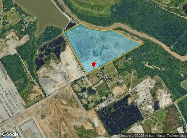
2600 Post Oak Rd
65127472510040000
Peter Sampson
Officebuilding
PETER SAMPSON ABST 1274 PG 725 TR 4 ACS 104.6125 INT202000007407 DD01062020 CO-DC 1274725100400 4NT12747251
AE
Dallas
48113C0520K
Texas
2024
104.85 AC
2025
Mesquite/Forney/Terrell
016903
Dallas/Ft Worth
14,477 SF
Dallas-Fort Worth-Arlington, TX
DEMOGRAPHICS near 2600 Post Oak Rd
1 Mile
3 Mile
5 Mile
2024 Total Population
62
14,633
39,843
2029 Population
66
14,961
40,182
Pop Growth 2024-2029
+ 6.45%
+ 2.24%
+ 0.85%
Average Age
32
34
33
2024 Total Households
18
3,740
10,763
HH Growth 2024-2029
+ 11.11%
+ 2.43%
+ 0.79%
Median Household Inc
$54,000
$50,261
$50,012
Avg Household Size
3.40
3.30
3.40
2024 Avg HH Vehicles
2.00
2.00
2.00
Median Home Value
$114,286
$126,863
$135,398
Median Year Built
2007
1994
1988
Nearby Places
Map Layers
Map Styles
 Street
 Aerial
- Restaurants
- Banks
- Shops
- Fitness
- Groceries
PUBLIC TRANSPORTATION
AIRPORT
Dallas Love Field
DRIVE
WALK
Distance
Dallas Love Field
33 min
20.5 mi
Dallas-Fort Worth International
DRIVE
WALK
Distance
Dallas-Fort Worth International
48 min
36.4 mi
Freight Ports
Port of Shreveport
DRIVE
WALK
Distance
Port of Shreveport
212 min
192.8 mi
Nearby Properties
Address
Land Use
TOTAL SIZE
Lot Size
Zoning
Address
Land Use
TOTAL SIZE
Lot Size
Zoning
1,097,520 SF
58.28 AC
Address
Land Use
TOTAL SIZE
Lot Size
Zoning
1,073,520 SF
55.17 AC
Z123
Address
Land Use
TOTAL SIZE
Lot Size
Zoning
1,039,360 SF
64.13 AC
Z123
Address
Land Use
TOTAL SIZE
Lot Size
Zoning
1,033,503 SF
51.34 AC
Address
Land Use
TOTAL SIZE
Lot Size
Zoning
1,004,674 SF
63.47 AC
Z123
Address
Land Use
TOTAL SIZE
Lot Size
Zoning
999,728 SF
48.45 AC
Z319
Address
Land Use
TOTAL SIZE
Lot Size
Zoning
1,013,833 SF
54.39 AC
Z102
Address
Land Use
TOTAL SIZE
Lot Size
Zoning
960,665 SF
46.03 AC
Z31
Address
Land Use
TOTAL SIZE
Lot Size
Zoning
800,737 SF
45.33 AC
Z123
Address
Land Use
TOTAL SIZE
Lot Size
Zoning
799,765 SF
45.66 AC
Z31
Address
Land Use
TOTAL SIZE
Lot Size
Zoning
754,897 SF
42.75 AC
Z123
Address
Land Use
TOTAL SIZE
Lot Size
Zoning
660,000 SF
39.24 AC
Z31
Address
Land Use
TOTAL SIZE
Lot Size
Zoning
698,880 SF
37.31 AC
Z31
Address
Land Use
TOTAL SIZE
Lot Size
Zoning
588,500 SF
32.61 AC
Z123
Address
Land Use
TOTAL SIZE
Lot Size
Zoning
571,880 SF
19.42 AC
Z123
Address
Land Use
TOTAL SIZE
Lot Size
Zoning
587,000 SF
33.94 AC
Z123
Address
Land Use
TOTAL SIZE
Lot Size
Zoning
626,100 SF
30.45 AC
Z398
Address
Land Use
TOTAL SIZE
Lot Size
Zoning
570,000 SF
30.48 AC
Z251
Address
Land Use
TOTAL SIZE
Lot Size
Zoning
565,259 SF
38.69 AC
Z123
Address
Land Use
TOTAL SIZE
Lot Size
Zoning
826,620 SF
39.67 AC
Z123
Address
Land Use
TOTAL SIZE
Lot Size
Zoning
416,000 SF
28.69 AC
Z123
Address
Land Use
TOTAL SIZE
Lot Size
Zoning
611,040 SF
39.98 AC
Z251
Address
Land Use
TOTAL SIZE
Lot Size
Zoning
530,207 SF
23 AC
Z31
Address
Land Use
TOTAL SIZE
Lot Size
Zoning
500,380 SF
32.56 AC
Z319
Address
Land Use
TOTAL SIZE
Lot Size
Zoning
431,190 SF
46.46 AC
Z251
Address
Land Use
TOTAL SIZE
Lot Size
Zoning
472,836 SF
31.34 AC
Z123
Address
Land Use
TOTAL SIZE
Lot Size
Zoning
395,099 SF
37.29 AC
Z123
Address
Land Use
TOTAL SIZE
Lot Size
Zoning
349,936 SF
24.34 AC
Z31
Address
Land Use
TOTAL SIZE
Lot Size
Zoning
334,800 SF
18.16 AC
Z251
Address
Land Use
TOTAL SIZE
Lot Size
Zoning
293,570 SF
14.36 AC
Z251
The World's #1 Commercial Real Estate Marketplace
Connect with us
© 2026 CoStar Group
The information above has been obtained from sources believed reliable. While we do not doubt its accuracy we have not verified it and make no guarantee, warranty or representation about it. It is your responsibility to independently confirm its accuracy and completeness. Any projections, opinions, assumptions, or estimates used are for example only and do not represent the current or future performance of the property. The value of this transaction to you depends on tax and other factors which should be evaluated by your tax, financial, and legal advisors. You and your advisors should conduct a careful, independent investigation of the property to determine to your satisfaction the suitability of the property for your needs.