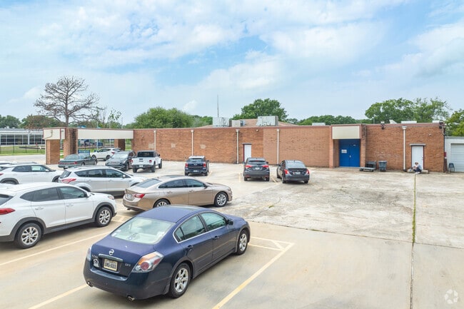
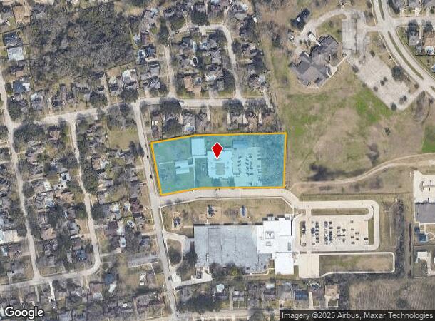
Property Record
2600 Stanley Ln, Seabrook, TX 77586

NEARBY LISTINGS FOR SALE OR LEASE
Property Detail
2600 Stanley Ln
0631450000019
Ruggles West
Publicschool
TRS 11 & 12C RUGGLES WEST
AE
Harris
48167C0050G
Texas
0
3.56 AC
2025
NASA/Clear Lake
341501
Houston
15,766 SF
Houston-The Woodlands-Sugar Land, TX
DEMOGRAPHICS near 2600 Stanley Ln
1 Mile
3 Mile
5 Mile
2024 Total Population
10,123
34,653
97,433
2029 Population
10,368
35,793
100,646
Pop Growth 2024-2029
+ 2.42%
+ 3.29%
+ 3.30%
Average Age
40
41
40
2024 Total Households
4,074
14,921
40,805
HH Growth 2024-2029
+ 2.53%
+ 3.46%
+ 3.36%
Median Household Inc
$100,656
$92,919
$92,075
Avg Household Size
2.50
2.30
2.40
2024 Avg HH Vehicles
2.00
2.00
2.00
Median Home Value
$307,479
$306,844
$294,927
Median Year Built
1988
1989
1988
Nearby Places
Map Layers
Map Styles
 Street
 Aerial
- Restaurants
- Banks
- Shops
- Fitness
- Groceries
PUBLIC TRANSPORTATION
AIRPORT
William P Hobby
DRIVE
WALK
Distance
William P Hobby
38 min
20.8 mi
Freight Ports
Port of Houston
DRIVE
WALK
Distance
Port of Houston
39 min
22.3 mi
SALE & LEASE HISTORY
LISTING DATE
SALE/LEASE

Oct 17, 2023
For Sale
Nearby Properties
Address
Land Use
TOTAL SIZE
Lot Size
Zoning
Address
Land Use
TOTAL SIZE
Lot Size
Zoning
176.73 AC
Address
Land Use
TOTAL SIZE
Lot Size
Zoning
8,762,629 SF
237.51 AC
Address
Land Use
TOTAL SIZE
Lot Size
Zoning
Address
Land Use
TOTAL SIZE
Lot Size
Zoning
3,972,042 SF
110.27 AC
Address
Land Use
TOTAL SIZE
Lot Size
Zoning
2,312,750 SF
70.59 AC
Address
Land Use
TOTAL SIZE
Lot Size
Zoning
Address
Land Use
TOTAL SIZE
Lot Size
Zoning
21.18 AC
Address
Land Use
TOTAL SIZE
Lot Size
Zoning
784,496 SF
37.65 AC
Address
Land Use
TOTAL SIZE
Lot Size
Zoning
7.04 AC
Address
Land Use
TOTAL SIZE
Lot Size
Zoning
Address
Land Use
TOTAL SIZE
Lot Size
Zoning
21.49 AC
Address
Land Use
TOTAL SIZE
Lot Size
Zoning
780,870 SF
22.72 AC
Address
Land Use
TOTAL SIZE
Lot Size
Zoning
400,835 SF
14.73 AC
Address
Land Use
TOTAL SIZE
Lot Size
Zoning
Address
Land Use
TOTAL SIZE
Lot Size
Zoning
480,480 SF
22.95 AC
Address
Land Use
TOTAL SIZE
Lot Size
Zoning
480,480 SF
20.09 AC
Address
Land Use
TOTAL SIZE
Lot Size
Zoning
468,294 SF
31.94 AC
Address
Land Use
TOTAL SIZE
Lot Size
Zoning
260,988 SF
11.78 AC
Address
Land Use
TOTAL SIZE
Lot Size
Zoning
370,220 SF
28.57 AC
Address
Land Use
TOTAL SIZE
Lot Size
Zoning
126.63 AC
Address
Land Use
TOTAL SIZE
Lot Size
Zoning
177.18 AC
Address
Land Use
TOTAL SIZE
Lot Size
Zoning
176.70 AC
Address
Land Use
TOTAL SIZE
Lot Size
Zoning
176.70 AC
Address
Land Use
TOTAL SIZE
Lot Size
Zoning
363,975 SF
23.01 AC
Address
Land Use
TOTAL SIZE
Lot Size
Zoning
273,648 SF
11.48 AC
Address
Land Use
TOTAL SIZE
Lot Size
Zoning
330,600 SF
14.88 AC
Address
Land Use
TOTAL SIZE
Lot Size
Zoning
43.89 AC
Address
Land Use
TOTAL SIZE
Lot Size
Zoning
295,992 SF
18.50 AC
Address
Land Use
TOTAL SIZE
Lot Size
Zoning
196,951 SF
10.90 AC
Address
Land Use
TOTAL SIZE
Lot Size
Zoning
The World's #1 Commercial Real Estate Marketplace
Connect with us
© 2025 CoStar Group
The information above has been obtained from sources believed reliable. While we do not doubt its accuracy we have not verified it and make no guarantee, warranty or representation about it. It is your responsibility to independently confirm its accuracy and completeness. Any projections, opinions, assumptions, or estimates used are for example only and do not represent the current or future performance of the property. The value of this transaction to you depends on tax and other factors which should be evaluated by your tax, financial, and legal advisors. You and your advisors should conduct a careful, independent investigation of the property to determine to your satisfaction the suitability of the property for your needs.