Property Record
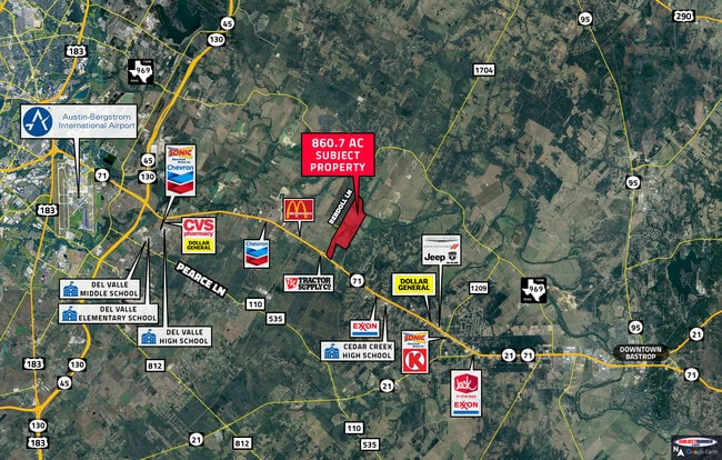
Highway 71, Bastrop, TX 78602
This Property Is For Sale
NEARBY LISTINGS FOR SALE OR LEASE
Property Detail
Highway 71
Austin
Navarro, Jose A.
Austin-Round Rock, TX
Bastrop
36495
Texas
Mobilemanufacturedhomeregardlessoflandownership
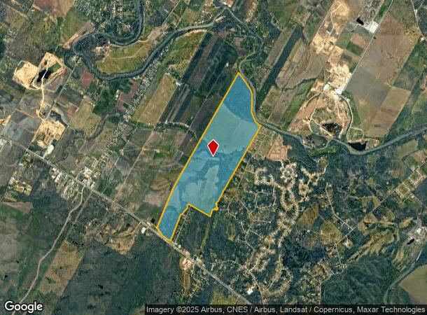
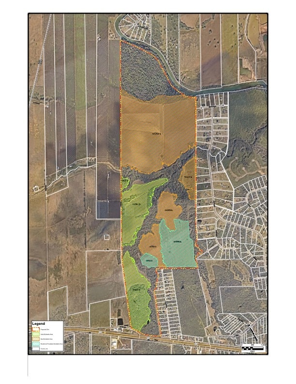
860.70 AC
A
Bastrop County
48021C0190G
DEMOGRAPHICS near Highway 71
1 Mile
3 Mile
5 Mile
2024 Total Population
237
3,708
11,897
2029 Population
301
4,512
14,199
Pop Growth 2024-2029
+ 27.00%
+ 21.68%
+ 19.35%
Average Age
44
42
38
2024 Total Households
93
1,392
4,055
HH Growth 2024-2029
+ 27.96%
+ 23.20%
+ 20.76%
Median Household Inc
$117,856
$78,629
$72,575
Avg Household Size
2.60
2.60
2.80
2024 Avg HH Vehicles
3.00
2.00
2.00
Median Home Value
$450,000
$317,708
$220,674
Median Year Built
2010
2001
1993
Nearby Places
Map Layers
Map Styles
 Street
 Aerial
- Restaurants
- Banks
- Shops
- Fitness
- Groceries
PUBLIC TRANSPORTATION
AIRPORT
Austin-Bergstrom International
DRIVE
WALK
Distance
Austin-Bergstrom International
29 min
15.3 mi
Freight Ports
Calhoun Port
DRIVE
WALK
Distance
Calhoun Port
185 min
153.4 mi
Nearby Properties
Address
Land Use
TOTAL SIZE
Lot Size
Zoning
Address
Land Use
TOTAL SIZE
Lot Size
Zoning
1.44 AC
Address
Land Use
TOTAL SIZE
Lot Size
Zoning
325.82 AC
Address
Land Use
TOTAL SIZE
Lot Size
Zoning
784 SF
316.76 AC
Address
Land Use
TOTAL SIZE
Lot Size
Zoning
48,254 SF
9.42 AC
Address
Land Use
TOTAL SIZE
Lot Size
Zoning
139.67 AC
Address
Land Use
TOTAL SIZE
Lot Size
Zoning
25,220 SF
17.65 AC
Address
Land Use
TOTAL SIZE
Lot Size
Zoning
900 SF
425.40 AC
Address
Land Use
TOTAL SIZE
Lot Size
Zoning
100 AC
Address
Land Use
TOTAL SIZE
Lot Size
Zoning
57,615 SF
15.69 AC
Address
Land Use
TOTAL SIZE
Lot Size
Zoning
896 SF
108.19 AC
Address
Land Use
TOTAL SIZE
Lot Size
Zoning
1,884 SF
11.61 AC
Address
Land Use
TOTAL SIZE
Lot Size
Zoning
2,666 SF
182.93 AC
Address
Land Use
TOTAL SIZE
Lot Size
Zoning
12,252 SF
10 AC
Address
Land Use
TOTAL SIZE
Lot Size
Zoning
126.06 AC
Address
Land Use
TOTAL SIZE
Lot Size
Zoning
24,717 SF
3.56 AC
Address
Land Use
TOTAL SIZE
Lot Size
Zoning
1,000 SF
2.99 AC
Address
Land Use
TOTAL SIZE
Lot Size
Zoning
22,337 SF
2.91 AC
Address
Land Use
TOTAL SIZE
Lot Size
Zoning
14,384 SF
1.53 AC
Address
Land Use
TOTAL SIZE
Lot Size
Zoning
13,467 SF
5.95 AC
Address
Land Use
TOTAL SIZE
Lot Size
Zoning
10,000 SF
53.07 AC
Address
Land Use
TOTAL SIZE
Lot Size
Zoning
Address
Land Use
TOTAL SIZE
Lot Size
Zoning
9,225 SF
0.74 AC
Address
Land Use
TOTAL SIZE
Lot Size
Zoning
4,952 SF
1.14 AC
Address
Land Use
TOTAL SIZE
Lot Size
Zoning
10,215 SF
2.91 AC
Address
Land Use
TOTAL SIZE
Lot Size
Zoning
4,452 SF
9 AC
Address
Land Use
TOTAL SIZE
Lot Size
Zoning
9,383 SF
6.57 AC
Address
Land Use
TOTAL SIZE
Lot Size
Zoning
9,150 SF
1.46 AC
Address
Land Use
TOTAL SIZE
Lot Size
Zoning
2.53 AC
Address
Land Use
TOTAL SIZE
Lot Size
Zoning
19,780 SF
3.07 AC
The World's #1 Commercial Real Estate Marketplace
Connect with us
© 2025 CoStar Group
The information above has been obtained from sources believed reliable. While we do not doubt its accuracy we have not verified it and make no guarantee, warranty or representation about it. It is your responsibility to independently confirm its accuracy and completeness. Any projections, opinions, assumptions, or estimates used are for example only and do not represent the current or future performance of the property. The value of this transaction to you depends on tax and other factors which should be evaluated by your tax, financial, and legal advisors. You and your advisors should conduct a careful, independent investigation of the property to determine to your satisfaction the suitability of the property for your needs.