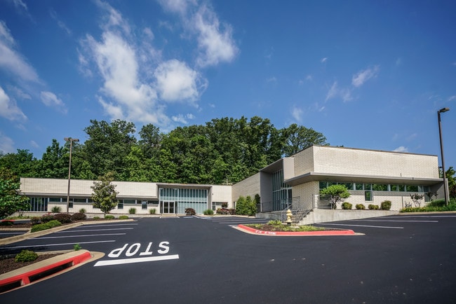
Property Record
2601 N Walton Blvd, Bentonville, AR 72712


Current Lease Availabilities
NEARBY LISTINGS FOR SALE OR LEASE
Property Detail
2601 N Walton Blvd
Fayetteville-Springdale-Rogers, AR-MO
Avignon Sub-Bentonville
01-08739-006
REPLAT P4-439.
Officebuilding
Benton
X
Arkansas
29119C0450D
47
2025
1.62 AC
2025
Bentonville
020606
Fayetteville/Springdale/Rogers
15,842 SF
DEMOGRAPHICS near 2601 N Walton Blvd
1 Mile
3 Mile
5 Mile
2024 Total Population
3,111
23,899
82,586
2029 Population
3,640
28,210
97,044
Pop Growth 2024-2029
+ 17.00%
+ 18.04%
+ 17.51%
Average Age
38
38
37
2024 Total Households
1,140
9,141
31,564
HH Growth 2024-2029
+ 17.11%
+ 18.27%
+ 17.59%
Median Household Inc
$137,645
$93,342
$87,949
Avg Household Size
2.70
2.60
2.60
2024 Avg HH Vehicles
2.00
2.00
2.00
Median Home Value
$443,000
$352,841
$272,108
Median Year Built
1996
1996
2000
Nearby Places
Map Layers
Map Styles
 Street
 Aerial
- Restaurants
- Banks
- Shops
- Fitness
- Groceries
PUBLIC TRANSPORTATION
AIRPORT
Northwest Arkansas Ntl
DRIVE
WALK
Distance
Northwest Arkansas Ntl
30 min
13.9 mi
Freight Ports
Tulsa Port of Inola
DRIVE
WALK
Distance
Tulsa Port of Inola
121 min
104.5 mi
Nearby Properties
Address
Land Use
TOTAL SIZE
Lot Size
Zoning
Address
Land Use
TOTAL SIZE
Lot Size
Zoning
552,541 SF
26.92 AC
Address
Land Use
TOTAL SIZE
Lot Size
Zoning
344,315 SF
12.74 AC
Address
Land Use
TOTAL SIZE
Lot Size
Zoning
149,727 SF
1.32 AC
Address
Land Use
TOTAL SIZE
Lot Size
Zoning
187,529 SF
37.78 AC
Address
Land Use
TOTAL SIZE
Lot Size
Zoning
247,292 SF
1.57 AC
Address
Land Use
TOTAL SIZE
Lot Size
Zoning
208,865 SF
7.73 AC
Address
Land Use
TOTAL SIZE
Lot Size
Zoning
256,469 SF
3.18 AC
Address
Land Use
TOTAL SIZE
Lot Size
Zoning
543,020 SF
9.15 AC
Address
Land Use
TOTAL SIZE
Lot Size
Zoning
39,047 SF
1.43 AC
Address
Land Use
TOTAL SIZE
Lot Size
Zoning
64,098 SF
2.17 AC
Address
Land Use
TOTAL SIZE
Lot Size
Zoning
18,413 SF
0.68 AC
Address
Land Use
TOTAL SIZE
Lot Size
Zoning
118,875 SF
5.06 AC
Address
Land Use
TOTAL SIZE
Lot Size
Zoning
239,145 SF
32.91 AC
Address
Land Use
TOTAL SIZE
Lot Size
Zoning
170,184 SF
10.51 AC
Address
Land Use
TOTAL SIZE
Lot Size
Zoning
161,358 SF
12.23 AC
Address
Land Use
TOTAL SIZE
Lot Size
Zoning
148,317 SF
1.74 AC
Address
Land Use
TOTAL SIZE
Lot Size
Zoning
175,184 SF
1.12 AC
Address
Land Use
TOTAL SIZE
Lot Size
Zoning
179,182 SF
19.21 AC
Address
Land Use
TOTAL SIZE
Lot Size
Zoning
27,874 SF
0.48 AC
Address
Land Use
TOTAL SIZE
Lot Size
Zoning
228,855 SF
1.21 AC
Address
Land Use
TOTAL SIZE
Lot Size
Zoning
68,423 SF
1.22 AC
Address
Land Use
TOTAL SIZE
Lot Size
Zoning
151,200 SF
8.63 AC
Address
Land Use
TOTAL SIZE
Lot Size
Zoning
9,672 SF
6.74 AC
Address
Land Use
TOTAL SIZE
Lot Size
Zoning
161,340 SF
4.67 AC
Address
Land Use
TOTAL SIZE
Lot Size
Zoning
71,586 SF
1.24 AC
Address
Land Use
TOTAL SIZE
Lot Size
Zoning
84,697 SF
10.08 AC
Address
Land Use
TOTAL SIZE
Lot Size
Zoning
31,870 SF
9.52 AC
Address
Land Use
TOTAL SIZE
Lot Size
Zoning
104,812 SF
42.30 AC
Address
Land Use
TOTAL SIZE
Lot Size
Zoning
76,684 SF
2.47 AC
Address
Land Use
TOTAL SIZE
Lot Size
Zoning
220,484 SF
5.05 AC
The World's #1 Commercial Real Estate Marketplace
Connect with us
© 2026 CoStar Group
The information above has been obtained from sources believed reliable. While we do not doubt its accuracy we have not verified it and make no guarantee, warranty or representation about it. It is your responsibility to independently confirm its accuracy and completeness. Any projections, opinions, assumptions, or estimates used are for example only and do not represent the current or future performance of the property. The value of this transaction to you depends on tax and other factors which should be evaluated by your tax, financial, and legal advisors. You and your advisors should conduct a careful, independent investigation of the property to determine to your satisfaction the suitability of the property for your needs.