Property Record
2601 S River Rd, Mchenry, IL 60051
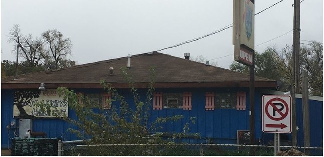

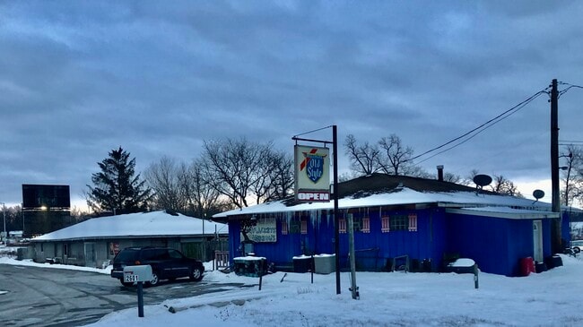
This Property Is For Sale
Property Detail
2601 S River Rd
Chicago-Naperville-Elgin, IL-IN
PART OF LOT A
15-17-177-002
McHenry
Commercialnec
Illinois
AE The base floodplain where base flood elevations are provided. AE Zones are now used on new format FIRMs instead of A1-A30 Zones.
a
2024
0.58 AC
2024
Far Northwest
870811
Chicago
3,400 SF
NEARBY LISTINGS FOR SALE OR LEASE
DEMOGRAPHICS near 2601 S River Rd
1 mile
3 mile
5 mile
2025 Total Population
3,699
19,350
75,347
2030 Population
3,744
19,545
76,497
Pop Growth 2025-2030
+ 1.22%
+ 1.01%
+ 1.53%
Average Age
42
42
41
2025 Total Households
1,499
7,472
28,517
HH Growth 2025-2030
+ 1.27%
+ 1.03%
+ 1.57%
Median Household Inc
$81,590
$98,947
$106,571
Avg Household Size
2.40
2.60
2.60
2025 Avg HH Vehicles
2.00
2.00
2.00
Median Home Value
$241,622
$277,121
$304,166
Median Year Built
1982
1986
1990
Nearby Places
Map Layers
Map Styles
 Street
 Aerial
Layers
 Traffic
 Biking
Places
Listings with unknown addresses are not visible on the map
- Restaurants
- Banks
- Shops
- Fitness
- Groceries
PUBLIC TRANSPORTATION
COMMUTER RAIL
Mchenry Station (Union Pacific Northwest Line - Northeast Illinois Regional Commuter Railroad (Metra))
Drive
Walk
Distance
Mchenry Station (Union Pacific Northwest Line - Northeast Illinois Regional Commuter Railroad (Metra))
14 min
6.2 mi
Pingree Road Station (Union Pacific Northwest Line - Northeast Illinois Regional Commuter Railroad (Metra))
Drive
Walk
Distance
Pingree Road Station (Union Pacific Northwest Line - Northeast Illinois Regional Commuter Railroad (Metra))
17 min
7.8 mi
AIRPORT
Chicago O'Hare International
Drive
Walk
Distance
Chicago O'Hare International
51 min
35.2 mi
Freight Ports
Port Milwaukee
Drive
Walk
Distance
Port Milwaukee
85 min
65.2 mi
Nearby Properties
Address
Land Use
TOTAL SIZE
Lot Size
Zoning
Address
Land Use
TOTAL SIZE
Lot Size
Zoning
241,227 SF
15.79 AC
Address
Land Use
TOTAL SIZE
Lot Size
Zoning
19,224 SF
7 AC
Address
Land Use
TOTAL SIZE
Lot Size
Zoning
212,880 SF
20.06 AC
Address
Land Use
TOTAL SIZE
Lot Size
Zoning
114,186 SF
17.14 AC
Address
Land Use
TOTAL SIZE
Lot Size
Zoning
448,000 SF
8.28 AC
Address
Land Use
TOTAL SIZE
Lot Size
Zoning
1,525,750 SF
7.55 AC
Address
Land Use
TOTAL SIZE
Lot Size
Zoning
60,202 SF
5 AC
Address
Land Use
TOTAL SIZE
Lot Size
Zoning
18,873 SF
159.95 AC
Address
Land Use
TOTAL SIZE
Lot Size
Zoning
20,403 SF
6.47 AC
Address
Land Use
TOTAL SIZE
Lot Size
Zoning
23,640 SF
1.26 AC
Address
Land Use
TOTAL SIZE
Lot Size
Zoning
163,800 SF
5 AC
Address
Land Use
TOTAL SIZE
Lot Size
Zoning
76,740 SF
12.03 AC
Address
Land Use
TOTAL SIZE
Lot Size
Zoning
87,600 SF
17.05 AC
Address
Land Use
TOTAL SIZE
Lot Size
Zoning
17,939 SF
16.60 AC
Address
Land Use
TOTAL SIZE
Lot Size
Zoning
25,900 SF
0.64 AC
Address
Land Use
TOTAL SIZE
Lot Size
Zoning
3,825 SF
2.99 AC
Address
Land Use
TOTAL SIZE
Lot Size
Zoning
150,600 SF
3 AC
Address
Land Use
TOTAL SIZE
Lot Size
Zoning
177,840 SF
2.53 AC
Address
Land Use
TOTAL SIZE
Lot Size
Zoning
14,820 SF
1.60 AC
Address
Land Use
TOTAL SIZE
Lot Size
Zoning
26,532 SF
10 AC
Address
Land Use
TOTAL SIZE
Lot Size
Zoning
21,730 SF
3.22 AC
Address
Land Use
TOTAL SIZE
Lot Size
Zoning
23,061 SF
1.43 AC
Address
Land Use
TOTAL SIZE
Lot Size
Zoning
Address
Land Use
TOTAL SIZE
Lot Size
Zoning
7,870 SF
35 AC
Address
Land Use
TOTAL SIZE
Lot Size
Zoning
18,200 SF
3.45 AC
Address
Land Use
TOTAL SIZE
Lot Size
Zoning
10,857 SF
1.68 AC
Address
Land Use
TOTAL SIZE
Lot Size
Zoning
12,994 SF
9.42 AC
Address
Land Use
TOTAL SIZE
Lot Size
Zoning
14,736 SF
2.31 AC
Address
Land Use
TOTAL SIZE
Lot Size
Zoning
16,243 SF
1.92 AC
Address
Land Use
TOTAL SIZE
Lot Size
Zoning
12,250 SF
5 AC
The World's #1 Commercial Real Estate Marketplace
Connect with us
© 2026 CoStar Group
The information above has been obtained from sources believed reliable. While we do not doubt its accuracy we have not verified it and make no guarantee, warranty or representation about it. It is your responsibility to independently confirm its accuracy and completeness. Any projections, opinions, assumptions, or estimates used are for example only and do not represent the current or future performance of the property. The value of this transaction to you depends on tax and other factors which should be evaluated by your tax, financial, and legal advisors. You and your advisors should conduct a careful, independent investigation of the property to determine to your satisfaction the suitability of the property for your needs.