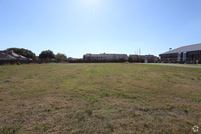
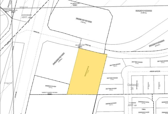
Property Record
2602 Crist Rd, Garland, TX 75040

NEARBY LISTINGS FOR SALE OR LEASE
-
-
-
-
NEQ President George Bush Turnpike & N Garland Ave
Garland, TX 75044
Rent Upon Request
1.22 AC Lots
Land
-
-
-
-
-
-
-
-
-
-
-
-
View all Garland listings for sale on LoopNet.com
Property Detail
2602 Crist Rd
Dallas-Fort Worth-Arlington, TX
T V Griffin
65052831010030100
T V GRIFFIN ABST 528 PG 310 TR 3.1 ACS 1.0489 INT201000225415 DD09022010 CO-DC 0528310100301 2CG05283101
Commercialacreage
Dallas
X
Texas
48113C0230K
1.05 AC
2024
Garland
2025
Dallas/Ft Worth
018105
DEMOGRAPHICS near 2602 Crist Rd
1 Mile
3 Mile
5 Mile
2024 Total Population
14,742
103,929
278,260
2029 Population
14,533
102,622
284,280
Pop Growth 2024-2029
(1.42%)
(1.26%)
+ 2.16%
Average Age
40
38
38
2024 Total Households
4,933
34,109
91,863
HH Growth 2024-2029
(1.60%)
(1.47%)
+ 2.07%
Median Household Inc
$72,419
$72,153
$79,103
Avg Household Size
2.90
3.00
2.90
2024 Avg HH Vehicles
2.00
2.00
2.00
Median Home Value
$227,013
$237,431
$262,097
Median Year Built
1982
1984
1983
Nearby Places
Map Layers
Map Styles
 Street
 Aerial
- Restaurants
- Banks
- Shops
- Fitness
- Groceries
PUBLIC TRANSPORTATION
AIRPORT
Dallas Love Field
DRIVE
WALK
Distance
Dallas Love Field
36 min
23.2 mi
Dallas-Fort Worth International
DRIVE
WALK
Distance
Dallas-Fort Worth International
42 min
35.3 mi
Freight Ports
Port of Shreveport
DRIVE
WALK
Distance
Port of Shreveport
215 min
195.1 mi
Nearby Properties
Address
Land Use
TOTAL SIZE
Lot Size
Zoning
Address
Land Use
TOTAL SIZE
Lot Size
Zoning
768,061 SF
42.03 AC
Z02
Address
Land Use
TOTAL SIZE
Lot Size
Zoning
650,164 SF
66.57 AC
Z02
Address
Land Use
TOTAL SIZE
Lot Size
Zoning
328,843 SF
11.70 AC
Z239
Address
Land Use
TOTAL SIZE
Lot Size
Zoning
433,745 SF
15.18 AC
Z02
Address
Land Use
TOTAL SIZE
Lot Size
Zoning
361,965 SF
11.12 AC
Z06
Address
Land Use
TOTAL SIZE
Lot Size
Zoning
231,434 SF
11.27 AC
Z06
Address
Land Use
TOTAL SIZE
Lot Size
Zoning
310,382 SF
11.78 AC
Z148
Address
Land Use
TOTAL SIZE
Lot Size
Zoning
181,200 SF
15.11 AC
Address
Land Use
TOTAL SIZE
Lot Size
Zoning
181,854 SF
14.51 AC
Z239
Address
Land Use
TOTAL SIZE
Lot Size
Zoning
423,253 SF
30.26 AC
Z239
Address
Land Use
TOTAL SIZE
Lot Size
Zoning
261,164 SF
32.58 AC
Address
Land Use
TOTAL SIZE
Lot Size
Zoning
342,658 SF
4.94 AC
Z239
Address
Land Use
TOTAL SIZE
Lot Size
Zoning
366,600 SF
8.09 AC
Z06
Address
Land Use
TOTAL SIZE
Lot Size
Zoning
244,025 SF
17.80 AC
Z02
Address
Land Use
TOTAL SIZE
Lot Size
Zoning
331,684 SF
9.80 AC
Z148
Address
Land Use
TOTAL SIZE
Lot Size
Zoning
403,206 SF
4 AC
Z239
Address
Land Use
TOTAL SIZE
Lot Size
Zoning
107,686 SF
30.09 AC
Z386
Address
Land Use
TOTAL SIZE
Lot Size
Zoning
232,771 SF
15.69 AC
Z160
Address
Land Use
TOTAL SIZE
Lot Size
Zoning
245,596 SF
14.24 AC
Z160
Address
Land Use
TOTAL SIZE
Lot Size
Zoning
117,500 SF
16.71 AC
Z239
Address
Land Use
TOTAL SIZE
Lot Size
Zoning
65,595 SF
19.22 AC
Z239
Address
Land Use
TOTAL SIZE
Lot Size
Zoning
286,500 SF
14.98 AC
Z160
Address
Land Use
TOTAL SIZE
Lot Size
Zoning
286,659 SF
9.94 AC
Z236
Address
Land Use
TOTAL SIZE
Lot Size
Zoning
187,440 SF
1.68 AC
Z25
Address
Land Use
TOTAL SIZE
Lot Size
Zoning
77,102 SF
27.47 AC
Z144
Address
Land Use
TOTAL SIZE
Lot Size
Zoning
226,524 SF
10.31 AC
Z160
Address
Land Use
TOTAL SIZE
Lot Size
Zoning
227,624 SF
10.31 AC
Z160
Address
Land Use
TOTAL SIZE
Lot Size
Zoning
198,950 SF
10 AC
Z160
Address
Land Use
TOTAL SIZE
Lot Size
Zoning
225,643 SF
10.42 AC
Z239
Address
Land Use
TOTAL SIZE
Lot Size
Zoning
198,488 SF
10.17 AC
Z239
The World's #1 Commercial Real Estate Marketplace
Connect with us
© 2026 CoStar Group
The information above has been obtained from sources believed reliable. While we do not doubt its accuracy we have not verified it and make no guarantee, warranty or representation about it. It is your responsibility to independently confirm its accuracy and completeness. Any projections, opinions, assumptions, or estimates used are for example only and do not represent the current or future performance of the property. The value of this transaction to you depends on tax and other factors which should be evaluated by your tax, financial, and legal advisors. You and your advisors should conduct a careful, independent investigation of the property to determine to your satisfaction the suitability of the property for your needs.