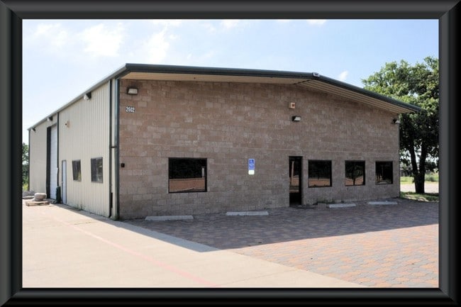
Property Record
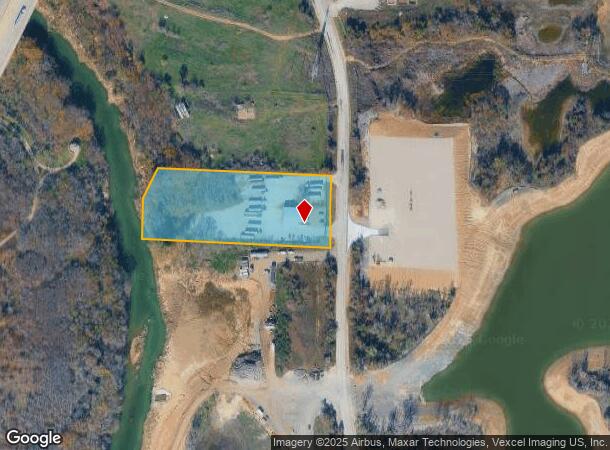
2602 Hardrock Rd, Grand Prairie, TX 75050
NEARBY LISTINGS FOR SALE OR LEASE
Property Detail
2602 Hardrock Rd
Dallas-Fort Worth-Arlington, TX
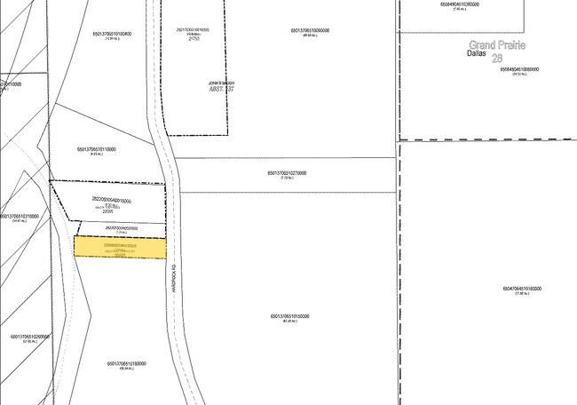
Kaleta Torti Replat
282205500A02R0000
KALETA TORTI REPLAT BLK A LT 2 ACS 3.0789 INT200900326620 DD11112009 CO-DC 2205500A00200 5CP2205500A
Warehouse
Dallas
AE
Texas
48439C0245L
2
2024
3.08 AC
2025
Upper Great Southwest
015304
Dallas/Ft Worth
4,620 SF
DEMOGRAPHICS near 2602 Hardrock Rd
1 Mile
3 Mile
5 Mile
2024 Total Population
1,239
63,616
241,177
2029 Population
1,218
63,934
244,281
Pop Growth 2024-2029
(1.69%)
+ 0.50%
+ 1.29%
Average Age
39
36
35
2024 Total Households
422
23,578
88,359
HH Growth 2024-2029
(1.90%)
+ 0.83%
+ 1.63%
Median Household Inc
$85,491
$61,202
$54,964
Avg Household Size
2.90
2.60
2.60
2024 Avg HH Vehicles
2.00
2.00
2.00
Median Home Value
$224,260
$221,470
$219,845
Median Year Built
1974
1983
1982
Nearby Places
Map Layers
Map Styles
 Street
 Aerial
- Restaurants
- Banks
- Shops
- Fitness
- Groceries
PUBLIC TRANSPORTATION
COMMUTER RAIL
DRIVE
WALK
Distance
5 min
2.5 mi
DRIVE
WALK
Distance
10 min
3.8 mi
AIRPORT
Dallas-Fort Worth International
DRIVE
WALK
Distance
Dallas-Fort Worth International
16 min
9.9 mi
Dallas Love Field
DRIVE
WALK
Distance
Dallas Love Field
25 min
16.0 mi
Nearby Properties
Address
Land Use
TOTAL SIZE
Lot Size
Zoning
Address
Land Use
TOTAL SIZE
Lot Size
Zoning
485,911 SF
54.76 AC
Address
Land Use
TOTAL SIZE
Lot Size
Zoning
522,294 SF
18.35 AC
Address
Land Use
TOTAL SIZE
Lot Size
Zoning
703,500 SF
47.38 AC
Z236
Address
Land Use
TOTAL SIZE
Lot Size
Zoning
496,283 SF
246.29 AC
Z236
Address
Land Use
TOTAL SIZE
Lot Size
Zoning
738,276 SF
40.57 AC
Z243
Address
Land Use
TOTAL SIZE
Lot Size
Zoning
450,535 SF
27.23 AC
Address
Land Use
TOTAL SIZE
Lot Size
Zoning
680,900 SF
32.25 AC
Z236
Address
Land Use
TOTAL SIZE
Lot Size
Zoning
683,300 SF
40.23 AC
Z01
Address
Land Use
TOTAL SIZE
Lot Size
Zoning
342,583 SF
23.87 AC
Address
Land Use
TOTAL SIZE
Lot Size
Zoning
334,057 SF
20.05 AC
Z312
Address
Land Use
TOTAL SIZE
Lot Size
Zoning
339,965 SF
15.59 AC
Address
Land Use
TOTAL SIZE
Lot Size
Zoning
358,350 SF
13.15 AC
Address
Land Use
TOTAL SIZE
Lot Size
Zoning
576,000 SF
55.36 AC
Z123
Address
Land Use
TOTAL SIZE
Lot Size
Zoning
285,194 SF
15.91 AC
Address
Land Use
TOTAL SIZE
Lot Size
Zoning
531,072 SF
26.50 AC
Z236
Address
Land Use
TOTAL SIZE
Lot Size
Zoning
585,000 SF
27.06 AC
Z123
Address
Land Use
TOTAL SIZE
Lot Size
Zoning
520,000 SF
28.92 AC
Z123
Address
Land Use
TOTAL SIZE
Lot Size
Zoning
264,010 SF
34.50 AC
Z190
Address
Land Use
TOTAL SIZE
Lot Size
Zoning
197,000 SF
25.51 AC
Z236
Address
Land Use
TOTAL SIZE
Lot Size
Zoning
500,256 SF
25.64 AC
Z123
Address
Land Use
TOTAL SIZE
Lot Size
Zoning
266,448 SF
17 AC
Z97
Address
Land Use
TOTAL SIZE
Lot Size
Zoning
304,636 SF
12.84 AC
Address
Land Use
TOTAL SIZE
Lot Size
Zoning
282,656 SF
14.84 AC
Address
Land Use
TOTAL SIZE
Lot Size
Zoning
309,386 SF
15.14 AC
Address
Land Use
TOTAL SIZE
Lot Size
Zoning
277,385 SF
14.33 AC
Address
Land Use
TOTAL SIZE
Lot Size
Zoning
224,486 SF
18.11 AC
Z236
Address
Land Use
TOTAL SIZE
Lot Size
Zoning
391,320 SF
21.78 AC
Address
Land Use
TOTAL SIZE
Lot Size
Zoning
251,392 SF
14.54 AC
Z190
Address
Land Use
TOTAL SIZE
Lot Size
Zoning
492,972 SF
24.23 AC
Address
Land Use
TOTAL SIZE
Lot Size
Zoning
261,338 SF
15.55 AC
The World's #1 Commercial Real Estate Marketplace
Connect with us
© 2025 CoStar Group
The information above has been obtained from sources believed reliable. While we do not doubt its accuracy we have not verified it and make no guarantee, warranty or representation about it. It is your responsibility to independently confirm its accuracy and completeness. Any projections, opinions, assumptions, or estimates used are for example only and do not represent the current or future performance of the property. The value of this transaction to you depends on tax and other factors which should be evaluated by your tax, financial, and legal advisors. You and your advisors should conduct a careful, independent investigation of the property to determine to your satisfaction the suitability of the property for your needs.