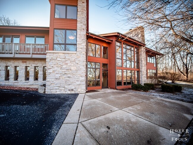
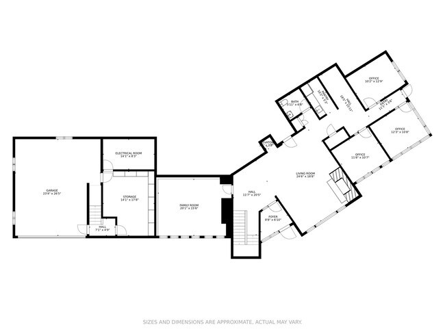
Property Record
2602 Il Route 176, Crystal Lake, IL 60014
NEARBY LISTINGS FOR SALE OR LEASE
Property Detail
2602 Il Route 176
14-25-200-030
None
Commercialnec
DOC 2021R0049207 THAT PT ANNEXED TO VILL OF PRAIRIE GROVE PER CIR CT 72-4045 PT W1/2 W1/2 E1/2
X
McHenry
17111C0238J
Illinois
2024
1.07 AC
2024
Far Northwest
871301
Chicago
5,614 SF
Chicago-Naperville-Elgin, IL-IN-WI
DEMOGRAPHICS near 2602 Il Route 176
1 Mile
3 Mile
5 Mile
2024 Total Population
1,465
27,790
84,995
2029 Population
1,480
27,978
85,168
Pop Growth 2024-2029
+ 1.02%
+ 0.68%
+ 0.20%
Average Age
43
41
41
2024 Total Households
543
10,310
31,678
HH Growth 2024-2029
+ 1.10%
+ 0.70%
+ 0.21%
Median Household Inc
$107,246
$96,266
$95,852
Avg Household Size
2.70
2.60
2.60
2024 Avg HH Vehicles
2.00
2.00
2.00
Median Home Value
$320,312
$284,096
$270,010
Median Year Built
1982
1986
1984
Nearby Places
Map Layers
Map Styles
 Street
 Aerial
- Restaurants
- Banks
- Shops
- Fitness
- Groceries
PUBLIC TRANSPORTATION
COMMUTER RAIL
Pingree Road Station (Union Pacific Northwest Line - Northeast Illinois Regional Commuter Railroad (Metra))
DRIVE
WALK
Distance
Pingree Road Station (Union Pacific Northwest Line - Northeast Illinois Regional Commuter Railroad (Metra))
11 min
4.6 mi
Cary Station (Union Pacific Northwest Line - Northeast Illinois Regional Commuter Railroad (Metra))
DRIVE
WALK
Distance
Cary Station (Union Pacific Northwest Line - Northeast Illinois Regional Commuter Railroad (Metra))
12 min
6.9 mi
AIRPORT
Chicago O'Hare International
DRIVE
WALK
Distance
Chicago O'Hare International
54 min
37.0 mi
Freight Ports
Port Milwaukee
DRIVE
WALK
Distance
Port Milwaukee
92 min
68.4 mi
SALE & LEASE HISTORY
LISTING DATE
SALE/LEASE

Jan 18, 2021
For Sale
Nearby Properties
Address
Land Use
TOTAL SIZE
Lot Size
Zoning
Address
Land Use
TOTAL SIZE
Lot Size
Zoning
393,554 SF
83.76 AC
Address
Land Use
TOTAL SIZE
Lot Size
Zoning
217,182 SF
22.43 AC
Address
Land Use
TOTAL SIZE
Lot Size
Zoning
187,594 SF
6.36 AC
Address
Land Use
TOTAL SIZE
Lot Size
Zoning
72,173 SF
5.23 AC
Address
Land Use
TOTAL SIZE
Lot Size
Zoning
114,186 SF
17.14 AC
Address
Land Use
TOTAL SIZE
Lot Size
Zoning
43.83 AC
Address
Land Use
TOTAL SIZE
Lot Size
Zoning
23,392 SF
2.68 AC
Address
Land Use
TOTAL SIZE
Lot Size
Zoning
50,358 SF
1.54 AC
Address
Land Use
TOTAL SIZE
Lot Size
Zoning
40,515 SF
2.97 AC
Address
Land Use
TOTAL SIZE
Lot Size
Zoning
33,873 SF
3.97 AC
Address
Land Use
TOTAL SIZE
Lot Size
Zoning
Address
Land Use
TOTAL SIZE
Lot Size
Zoning
21,902 SF
10.78 AC
Address
Land Use
TOTAL SIZE
Lot Size
Zoning
3.48 AC
Address
Land Use
TOTAL SIZE
Lot Size
Zoning
40,917 SF
10.07 AC
Address
Land Use
TOTAL SIZE
Lot Size
Zoning
101,467 SF
50.04 AC
Address
Land Use
TOTAL SIZE
Lot Size
Zoning
4,438 SF
2.74 AC
Address
Land Use
TOTAL SIZE
Lot Size
Zoning
45,468 SF
4.96 AC
Address
Land Use
TOTAL SIZE
Lot Size
Zoning
25,900 SF
0.64 AC
Address
Land Use
TOTAL SIZE
Lot Size
Zoning
18,172 SF
2.34 AC
Address
Land Use
TOTAL SIZE
Lot Size
Zoning
16,800 SF
3.43 AC
Address
Land Use
TOTAL SIZE
Lot Size
Zoning
31,341 SF
2.14 AC
Address
Land Use
TOTAL SIZE
Lot Size
Zoning
150,600 SF
3 AC
Address
Land Use
TOTAL SIZE
Lot Size
Zoning
29,760 SF
5.05 AC
Address
Land Use
TOTAL SIZE
Lot Size
Zoning
15,978 SF
1.88 AC
Address
Land Use
TOTAL SIZE
Lot Size
Zoning
177,840 SF
2.53 AC
Address
Land Use
TOTAL SIZE
Lot Size
Zoning
18,100 SF
1.64 AC
Address
Land Use
TOTAL SIZE
Lot Size
Zoning
15,990 SF
1.80 AC
Address
Land Use
TOTAL SIZE
Lot Size
Zoning
7,870 SF
35 AC
Address
Land Use
TOTAL SIZE
Lot Size
Zoning
23,061 SF
1.43 AC
Address
Land Use
TOTAL SIZE
Lot Size
Zoning
14,736 SF
2.31 AC
The World's #1 Commercial Real Estate Marketplace
Connect with us
© 2025 CoStar Group
The information above has been obtained from sources believed reliable. While we do not doubt its accuracy we have not verified it and make no guarantee, warranty or representation about it. It is your responsibility to independently confirm its accuracy and completeness. Any projections, opinions, assumptions, or estimates used are for example only and do not represent the current or future performance of the property. The value of this transaction to you depends on tax and other factors which should be evaluated by your tax, financial, and legal advisors. You and your advisors should conduct a careful, independent investigation of the property to determine to your satisfaction the suitability of the property for your needs.