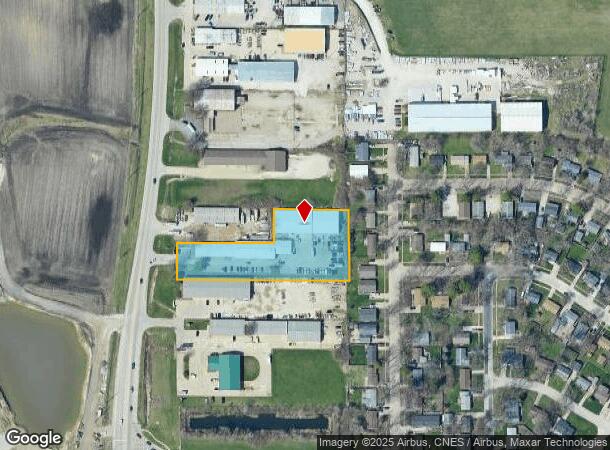
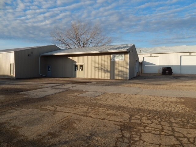
Property Record
2602 N Mattis Ave, Champaign, IL 61822

NEARBY LISTINGS FOR SALE OR LEASE
Property Detail
2602 N Mattis Ave
Champaign-Urbana, IL
Tatmans Whitorjust Sub
41-14-35-351-025
LOT 102 TATMANS WHITORJUST SUB
Commercialnec
Champaign
X
Illinois
17019C0294D
102
2023
1 AC
2024
Champaign-Urbana
000800
Other Market Areas
DEMOGRAPHICS near 2602 N Mattis Ave
1 Mile
3 Mile
5 Mile
2024 Total Population
4,339
42,348
121,733
2029 Population
4,385
42,354
122,035
Pop Growth 2024-2029
+ 1.06%
+ 0.01%
+ 0.25%
Average Age
36
37
34
2024 Total Households
1,838
19,570
50,217
HH Growth 2024-2029
+ 0.82%
(0.04%)
+ 0.29%
Median Household Inc
$54,739
$56,372
$49,089
Avg Household Size
2.30
2.10
2.10
2024 Avg HH Vehicles
2.00
1.00
1.00
Median Home Value
$69,328
$153,646
$180,210
Median Year Built
1977
1976
1983
Nearby Places
Map Layers
Map Styles
 Street
 Aerial
- Restaurants
- Banks
- Shops
- Fitness
- Groceries
PUBLIC TRANSPORTATION
COMMUTER RAIL
Champaign-Urbana (City of New Orleans - Amtrak, Illini - Amtrak, Saluki - Amtrak)
DRIVE
WALK
Distance
Champaign-Urbana (City of New Orleans - Amtrak, Illini - Amtrak, Saluki - Amtrak)
8 min
3.5 mi
AIRPORT
University of Illinois/Willard
DRIVE
WALK
Distance
University of Illinois/Willard
22 min
13.4 mi
Freight Ports
Port Milwaukee
DRIVE
WALK
Distance
Port Milwaukee
254 min
218.4 mi
SALE & LEASE HISTORY
LISTING DATE
SALE/LEASE

Nov 14, 2016
For Lease
Jan 05, 2023
For Sale
Nearby Properties
Address
Land Use
TOTAL SIZE
Lot Size
Zoning
Address
Land Use
TOTAL SIZE
Lot Size
Zoning
32.35 AC
Address
Land Use
TOTAL SIZE
Lot Size
Zoning
18.58 AC
Address
Land Use
TOTAL SIZE
Lot Size
Zoning
8.78 AC
Address
Land Use
TOTAL SIZE
Lot Size
Zoning
30.37 AC
Address
Land Use
TOTAL SIZE
Lot Size
Zoning
Address
Land Use
TOTAL SIZE
Lot Size
Zoning
2.35 AC
Address
Land Use
TOTAL SIZE
Lot Size
Zoning
1.85 AC
Address
Land Use
TOTAL SIZE
Lot Size
Zoning
23.33 AC
Address
Land Use
TOTAL SIZE
Lot Size
Zoning
0.53 AC
Address
Land Use
TOTAL SIZE
Lot Size
Zoning
Address
Land Use
TOTAL SIZE
Lot Size
Zoning
Address
Land Use
TOTAL SIZE
Lot Size
Zoning
Address
Land Use
TOTAL SIZE
Lot Size
Zoning
25.18 AC
Address
Land Use
TOTAL SIZE
Lot Size
Zoning
13.51 AC
Address
Land Use
TOTAL SIZE
Lot Size
Zoning
21.02 AC
Address
Land Use
TOTAL SIZE
Lot Size
Zoning
Address
Land Use
TOTAL SIZE
Lot Size
Zoning
11.90 AC
Address
Land Use
TOTAL SIZE
Lot Size
Zoning
Address
Land Use
TOTAL SIZE
Lot Size
Zoning
Address
Land Use
TOTAL SIZE
Lot Size
Zoning
Address
Land Use
TOTAL SIZE
Lot Size
Zoning
Address
Land Use
TOTAL SIZE
Lot Size
Zoning
Address
Land Use
TOTAL SIZE
Lot Size
Zoning
61.86 AC
Address
Land Use
TOTAL SIZE
Lot Size
Zoning
13.56 AC
Address
Land Use
TOTAL SIZE
Lot Size
Zoning
0.41 AC
Address
Land Use
TOTAL SIZE
Lot Size
Zoning
Address
Land Use
TOTAL SIZE
Lot Size
Zoning
Address
Land Use
TOTAL SIZE
Lot Size
Zoning
Address
Land Use
TOTAL SIZE
Lot Size
Zoning
Address
Land Use
TOTAL SIZE
Lot Size
Zoning
30.13 AC
The World's #1 Commercial Real Estate Marketplace
Connect with us
© 2025 CoStar Group
The information above has been obtained from sources believed reliable. While we do not doubt its accuracy we have not verified it and make no guarantee, warranty or representation about it. It is your responsibility to independently confirm its accuracy and completeness. Any projections, opinions, assumptions, or estimates used are for example only and do not represent the current or future performance of the property. The value of this transaction to you depends on tax and other factors which should be evaluated by your tax, financial, and legal advisors. You and your advisors should conduct a careful, independent investigation of the property to determine to your satisfaction the suitability of the property for your needs.