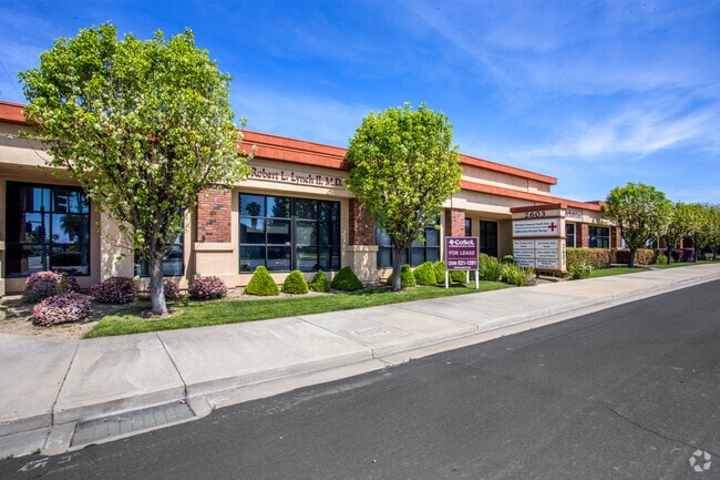
Property Record
2603 Patterson Rd, Riverbank, CA 95367


Property Detail
2603 Patterson Rd
075-09-71
RIVERBANK ACREAGE TRACT LOT 89 & 90
Medicalbuilding
Stanislaus
C2
California
B and X Area of moderate flood hazard, usually the area between the limits of the 100-year and 500-year floods.
89,90
2025
1.18 AC
2025
Modesto
000302
Stockton/Modesto
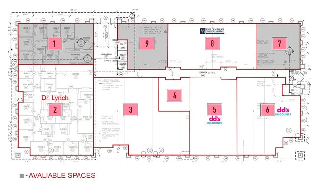
17,000 SF
Modesto, CA
NEARBY LISTINGS FOR SALE OR LEASE
DEMOGRAPHICS near 2603 Patterson Rd
1 mile
3 mile
5 mile
2025 Total Population
14,867
34,174
125,817
2030 Population
14,957
34,485
126,933
Pop Growth 2025-2030
+ 0.61%
+ 0.91%
+ 0.89%
Average Age
37
38
39
2025 Total Households
4,493
10,524
42,590
HH Growth 2025-2030
+ 0.62%
+ 0.93%
+ 0.87%
Median Household Inc
$91,130
$97,943
$92,082
Avg Household Size
3.30
3.20
2.90
2025 Avg HH Vehicles
2.00
2.00
2.00
Median Home Value
$479,750
$497,730
$483,859
Median Year Built
1991
1992
1983
Nearby Places
Map Layers
Map Styles
 Street
 Aerial
Layers
 Traffic
 Biking
Places
Listings with unknown addresses are not visible on the map
- Restaurants
- Banks
- Shops
- Fitness
- Groceries
PUBLIC TRANSPORTATION
AIRPORT
Stockton Metro
Drive
Walk
Distance
Stockton Metro
38 min
26.8 mi
Freight Ports
Port of Stockton
Drive
Walk
Distance
Port of Stockton
47 min
35.2 mi
SALE & LEASE HISTORY
LISTING DATE
SALE/LEASE

Sep 25, 2016
For Lease
Nov 08, 2021
For Lease
Nearby Properties
Address
Land Use
TOTAL SIZE
Lot Size
Zoning
Address
Land Use
TOTAL SIZE
Lot Size
Zoning
15.68 AC
RIVPD
Address
Land Use
TOTAL SIZE
Lot Size
Zoning
186,665 SF
10.22 AC
Address
Land Use
TOTAL SIZE
Lot Size
Zoning
123,575 SF
10 AC
PC
Address
Land Use
TOTAL SIZE
Lot Size
Zoning
60,156 SF
16.20 AC
Address
Land Use
TOTAL SIZE
Lot Size
Zoning
72,338 SF
5.98 AC
RIVC1
Address
Land Use
TOTAL SIZE
Lot Size
Zoning
140,669 SF
10.96 AC
PC
Address
Land Use
TOTAL SIZE
Lot Size
Zoning
77,578 SF
7.93 AC
Address
Land Use
TOTAL SIZE
Lot Size
Zoning
56,265 SF
4.94 AC
MODPD
Address
Land Use
TOTAL SIZE
Lot Size
Zoning
83,987 SF
4.59 AC
RIVR3
Address
Land Use
TOTAL SIZE
Lot Size
Zoning
88,274 SF
6.32 AC
PC
Address
Land Use
TOTAL SIZE
Lot Size
Zoning
28,560 SF
9.62 AC
Address
Land Use
TOTAL SIZE
Lot Size
Zoning
36,817 SF
4.51 AC
Address
Land Use
TOTAL SIZE
Lot Size
Zoning
85,218 SF
3.51 AC
Address
Land Use
TOTAL SIZE
Lot Size
Zoning
57,760 SF
4.89 AC
PC
Address
Land Use
TOTAL SIZE
Lot Size
Zoning
465,061 SF
26.66 AC
CERM1
Address
Land Use
TOTAL SIZE
Lot Size
Zoning
2,201 SF
0.61 AC
Address
Land Use
TOTAL SIZE
Lot Size
Zoning
41,698 SF
5.17 AC
Address
Land Use
TOTAL SIZE
Lot Size
Zoning
369.73 AC
Address
Land Use
TOTAL SIZE
Lot Size
Zoning
1,304 SF
57.16 AC
A240
Address
Land Use
TOTAL SIZE
Lot Size
Zoning
201,657 SF
8.53 AC
Address
Land Use
TOTAL SIZE
Lot Size
Zoning
42,000 SF
2.84 AC
Address
Land Use
TOTAL SIZE
Lot Size
Zoning
20,623 SF
18.05 AC
Address
Land Use
TOTAL SIZE
Lot Size
Zoning
71,339 SF
4.26 AC
R3
Address
Land Use
TOTAL SIZE
Lot Size
Zoning
148,750 SF
11.88 AC
Address
Land Use
TOTAL SIZE
Lot Size
Zoning
1,620 SF
299.40 AC
A240
Address
Land Use
TOTAL SIZE
Lot Size
Zoning
124,025 SF
7.51 AC
Address
Land Use
TOTAL SIZE
Lot Size
Zoning
616 SF
95.81 AC
A240
Address
Land Use
TOTAL SIZE
Lot Size
Zoning
68,680 SF
3.35 AC
Address
Land Use
TOTAL SIZE
Lot Size
Zoning
12,040 SF
1.35 AC
PC
Address
Land Use
TOTAL SIZE
Lot Size
Zoning
153,738 SF
9.58 AC
The World's #1 Commercial Real Estate Marketplace
Connect with us
© 2026 CoStar Group
The information above has been obtained from sources believed reliable. While we do not doubt its accuracy we have not verified it and make no guarantee, warranty or representation about it. It is your responsibility to independently confirm its accuracy and completeness. Any projections, opinions, assumptions, or estimates used are for example only and do not represent the current or future performance of the property. The value of this transaction to you depends on tax and other factors which should be evaluated by your tax, financial, and legal advisors. You and your advisors should conduct a careful, independent investigation of the property to determine to your satisfaction the suitability of the property for your needs.