Property Record
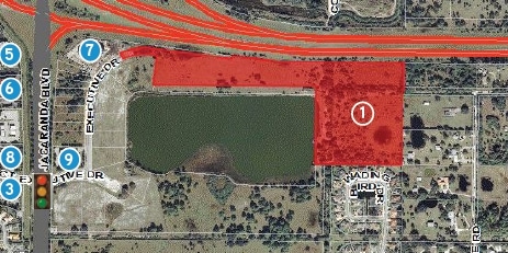
2604 Executive Dr, Venice, FL 34292

Property Detail
2604 Executive Dr
0415-02-0003
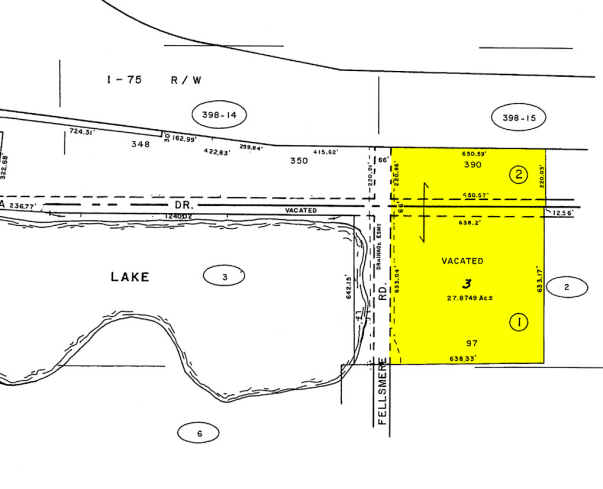
PORTION OF SEC 2 & 11-39-19 DESC AS COM AT NE COR OF SARASOTA COUNTY INTERSTATE BUSINESS CENTER SOUTH PH 1, SAME BEING THE SLY R/W OF I-75 TH S 82-20-01 E 422.85 FT TH S 89-26-31 E 1132.17 FT
Multifamilydwelling
SARASOTA
RMF3
Florida
AE The base floodplain where base flood elevations are provided. AE Zones are now used on new format FIRMs instead of A1-A30 Zones.
97
2024
16.80 AC
2025
Sarasota
002716
Tampa/St Petersburg
333,296 SF
North Port-Bradenton-Sarasota, FL
NEARBY LISTINGS FOR SALE OR LEASE
DEMOGRAPHICS near 2604 Executive Dr
1 mile
3 mile
5 mile
2025 Total Population
1,874
33,170
87,010
2030 Population
2,022
35,697
93,703
Pop Growth 2025-2030
+ 7.90%
+ 7.62%
+ 7.69%
Average Age
53
61
59
2025 Total Households
838
16,685
43,619
HH Growth 2025-2030
+ 7.88%
+ 7.58%
+ 7.77%
Median Household Inc
$75,387
$83,683
$77,689
Avg Household Size
2.20
1.90
1.90
2025 Avg HH Vehicles
2.00
2.00
2.00
Median Home Value
$499,999
$467,407
$438,537
Median Year Built
2010
2001
1993
Nearby Places
Map Layers
Map Styles
 Street
 Aerial
Layers
 Traffic
 Biking
Places
Listings with unknown addresses are not visible on the map
- Restaurants
- Banks
- Shops
- Fitness
- Groceries
PUBLIC TRANSPORTATION
AIRPORT
Sarasota/Bradenton International
Drive
Walk
Distance
Sarasota/Bradenton International
41 min
30.0 mi
Punta Gorda
Drive
Walk
Distance
Punta Gorda
42 min
33.7 mi
Freight Ports
Port Manatee
Drive
Walk
Distance
Port Manatee
54 min
42.5 mi
Nearby Properties
Address
Land Use
TOTAL SIZE
Lot Size
Zoning
Address
Land Use
TOTAL SIZE
Lot Size
Zoning
432,671 SF
48.53 AC
RMF2
Address
Land Use
TOTAL SIZE
Lot Size
Zoning
421,272 SF
31.96 AC
PUD
Address
Land Use
TOTAL SIZE
Lot Size
Zoning
273,036 SF
28.76 AC
RMF3
Address
Land Use
TOTAL SIZE
Lot Size
Zoning
238,850 SF
18.24 AC
LE
Address
Land Use
TOTAL SIZE
Lot Size
Zoning
191,373 SF
23.12 AC
RMF2
Address
Land Use
TOTAL SIZE
Lot Size
Zoning
48,681 SF
5 AC
OPI
Address
Land Use
TOTAL SIZE
Lot Size
Zoning
177,646 SF
5.23 AC
LE
Address
Land Use
TOTAL SIZE
Lot Size
Zoning
183,584 SF
14.54 AC
PUD
Address
Land Use
TOTAL SIZE
Lot Size
Zoning
252,213 SF
13.49 AC
LE
Address
Land Use
TOTAL SIZE
Lot Size
Zoning
123,659 SF
50.42 AC
RSF2
Address
Land Use
TOTAL SIZE
Lot Size
Zoning
81,883 SF
11.90 AC
CSC
Address
Land Use
TOTAL SIZE
Lot Size
Zoning
115,360 SF
14.60 AC
ILW
Address
Land Use
TOTAL SIZE
Lot Size
Zoning
146,990 SF
8.90 AC
CG
Address
Land Use
TOTAL SIZE
Lot Size
Zoning
63,549 SF
6.26 AC
OPI
Address
Land Use
TOTAL SIZE
Lot Size
Zoning
98,113 SF
12.05 AC
CSC
Address
Land Use
TOTAL SIZE
Lot Size
Zoning
78,975 SF
8.40 AC
RSF4
Address
Land Use
TOTAL SIZE
Lot Size
Zoning
66,899 SF
30.10 AC
GU
Address
Land Use
TOTAL SIZE
Lot Size
Zoning
121,747 SF
17.54 AC
OUE1
Address
Land Use
TOTAL SIZE
Lot Size
Zoning
101,219 SF
4.90 AC
OPI
Address
Land Use
TOTAL SIZE
Lot Size
Zoning
76,247 SF
13.89 AC
CG
Address
Land Use
TOTAL SIZE
Lot Size
Zoning
125,001 SF
3.13 AC
CG
Address
Land Use
TOTAL SIZE
Lot Size
Zoning
8,040 SF
46.23 AC
RMH
Address
Land Use
TOTAL SIZE
Lot Size
Zoning
92,802 SF
4.78 AC
CN
Address
Land Use
TOTAL SIZE
Lot Size
Zoning
74,691 SF
2.99 AC
RSF2
Address
Land Use
TOTAL SIZE
Lot Size
Zoning
114,693 SF
15.16 AC
PUD
Address
Land Use
TOTAL SIZE
Lot Size
Zoning
30,560 SF
9.92 AC
G
Address
Land Use
TOTAL SIZE
Lot Size
Zoning
28,323 SF
10.21 AC
CG
Address
Land Use
TOTAL SIZE
Lot Size
Zoning
3,931 SF
51.50 AC
CG
Address
Land Use
TOTAL SIZE
Lot Size
Zoning
46,327 SF
75.56 AC
ROS
The World's #1 Commercial Real Estate Marketplace
Connect with us
© 2026 CoStar Group
The information above has been obtained from sources believed reliable. While we do not doubt its accuracy we have not verified it and make no guarantee, warranty or representation about it. It is your responsibility to independently confirm its accuracy and completeness. Any projections, opinions, assumptions, or estimates used are for example only and do not represent the current or future performance of the property. The value of this transaction to you depends on tax and other factors which should be evaluated by your tax, financial, and legal advisors. You and your advisors should conduct a careful, independent investigation of the property to determine to your satisfaction the suitability of the property for your needs.