Property Record
2604 N East Ave, Panama City, FL 32405


NEARBY LISTINGS FOR SALE OR LEASE
Property Detail
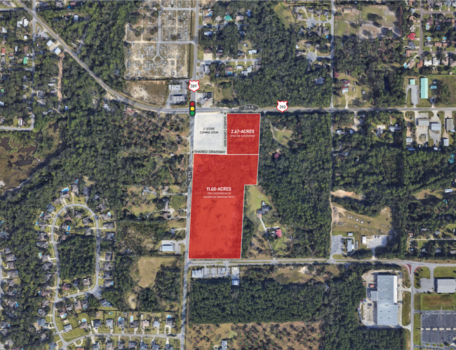
2604 N East Ave
Panama City, FL
St Andrews Bay Development Cos Plat
11573-000-000
15 3S 14W -39.9- 103A COM SW COR OF PRCL DESC IN ORB 1673 P 742 TH W ALG N ROW LI OF ABERDEEN PKWY 130 FOR POB CONT W 476.39 TO E ROW LI OF CO RD 389 TH NLY 1004.74 E 307.19 N 372.57 TO S ROW LI OF ST RD 390 TH E 313.31 S 648.22 TO NW COR OF PRCL DES
Commercialacreage
Bay
A
Florida
12005C0332J
56
2023
14.26 AC
2024
Panama City
001302
Other Market Areas
1,320 SF
DEMOGRAPHICS near 2604 N East Ave
1 Mile
3 Mile
5 Mile
2024 Total Population
4,984
29,801
55,038
2029 Population
5,168
31,274
58,260
Pop Growth 2024-2029
+ 3.69%
+ 4.94%
+ 5.85%
Average Age
40
40
40
2024 Total Households
1,813
11,196
20,515
HH Growth 2024-2029
+ 4.19%
+ 5.34%
+ 6.25%
Median Household Inc
$86,422
$71,059
$62,291
Avg Household Size
2.70
2.60
2.50
2024 Avg HH Vehicles
2.00
2.00
2.00
Median Home Value
$267,081
$241,524
$230,125
Median Year Built
1988
1992
1990
Nearby Places
Map Layers
Map Styles
 Street
 Aerial
- Restaurants
- Banks
- Shops
- Fitness
- Groceries
PUBLIC TRANSPORTATION
AIRPORT
Northwest Florida Beaches International
DRIVE
WALK
Distance
Northwest Florida Beaches International
29 min
18.5 mi
Freight Ports
Port of Panama City
DRIVE
WALK
Distance
Port of Panama City
17 min
9.1 mi
Nearby Properties
Address
Land Use
TOTAL SIZE
Lot Size
Zoning
Address
Land Use
TOTAL SIZE
Lot Size
Zoning
279,378 SF
13.24 AC
PC07
Address
Land Use
TOTAL SIZE
Lot Size
Zoning
277,246 SF
16 AC
BC15
Address
Land Use
TOTAL SIZE
Lot Size
Zoning
354,592 SF
24 AC
UND
Address
Land Use
TOTAL SIZE
Lot Size
Zoning
239,259 SF
15.86 AC
UND
Address
Land Use
TOTAL SIZE
Lot Size
Zoning
252,630 SF
10.70 AC
Address
Land Use
TOTAL SIZE
Lot Size
Zoning
281,578 SF
21.66 AC
UND
Address
Land Use
TOTAL SIZE
Lot Size
Zoning
206,758 SF
25.65 AC
SB
Address
Land Use
TOTAL SIZE
Lot Size
Zoning
115,472 SF
9.10 AC
Address
Land Use
TOTAL SIZE
Lot Size
Zoning
238,930 SF
39.18 AC
PSP
Address
Land Use
TOTAL SIZE
Lot Size
Zoning
185,884 SF
24 AC
BC15
Address
Land Use
TOTAL SIZE
Lot Size
Zoning
165,098 SF
9.67 AC
PC04
Address
Land Use
TOTAL SIZE
Lot Size
Zoning
81,774 SF
17.46 AC
PC05
Address
Land Use
TOTAL SIZE
Lot Size
Zoning
350,458 SF
16.29 AC
UND
Address
Land Use
TOTAL SIZE
Lot Size
Zoning
224,823 SF
59.80 AC
PSP
Address
Land Use
TOTAL SIZE
Lot Size
Zoning
113,514 SF
14.51 AC
UND
Address
Land Use
TOTAL SIZE
Lot Size
Zoning
112,836 SF
20 AC
UND
Address
Land Use
TOTAL SIZE
Lot Size
Zoning
92,299 SF
4.67 AC
Address
Land Use
TOTAL SIZE
Lot Size
Zoning
157,600 SF
17.68 AC
UND
Address
Land Use
TOTAL SIZE
Lot Size
Zoning
150,393 SF
8.40 AC
UND
Address
Land Use
TOTAL SIZE
Lot Size
Zoning
93,125 SF
12.05 AC
PI
Address
Land Use
TOTAL SIZE
Lot Size
Zoning
64,000 SF
9.84 AC
UND
Address
Land Use
TOTAL SIZE
Lot Size
Zoning
89,000 SF
4.65 AC
BC15
Address
Land Use
TOTAL SIZE
Lot Size
Zoning
241.76 AC
BC01
Address
Land Use
TOTAL SIZE
Lot Size
Zoning
41,519 SF
60 AC
UND
Address
Land Use
TOTAL SIZE
Lot Size
Zoning
53,562 SF
14.22 AC
Address
Land Use
TOTAL SIZE
Lot Size
Zoning
131,236 SF
9.17 AC
PC09
Address
Land Use
TOTAL SIZE
Lot Size
Zoning
46,176 SF
1.36 AC
PC09
Address
Land Use
TOTAL SIZE
Lot Size
Zoning
94,000 SF
19.92 AC
PC09
Address
Land Use
TOTAL SIZE
Lot Size
Zoning
139,911 SF
37.43 AC
PSP
Address
Land Use
TOTAL SIZE
Lot Size
Zoning
57,807 SF
11.64 AC
UND
The World's #1 Commercial Real Estate Marketplace
Connect with us
© 2025 CoStar Group
The information above has been obtained from sources believed reliable. While we do not doubt its accuracy we have not verified it and make no guarantee, warranty or representation about it. It is your responsibility to independently confirm its accuracy and completeness. Any projections, opinions, assumptions, or estimates used are for example only and do not represent the current or future performance of the property. The value of this transaction to you depends on tax and other factors which should be evaluated by your tax, financial, and legal advisors. You and your advisors should conduct a careful, independent investigation of the property to determine to your satisfaction the suitability of the property for your needs.