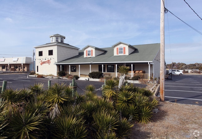
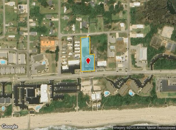
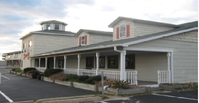
Property Record
2604 W Fort Macon Rd, Atlantic Beach, NC 28512
NEARBY LISTINGS FOR SALE OR LEASE
-
-
View all Atlantic Beach listings for sale on LoopNet.com
Property Detail
2604 W Fort Macon Rd
6365.15.72.3696000
Knollwood Banks
Restaurantbuilding
L5 10 PTL11 BA KNOLLWOOD BANKS
AE
Carteret
3720636500K
North Carolina
2025
5,10-11
2025
1.09 AC
971103
Other Market Areas
8,882 SF
Morehead City, NC
DEMOGRAPHICS near 2604 W Fort Macon Rd
1 Mile
3 Mile
5 Mile
2024 Total Population
744
9,313
20,831
2029 Population
845
9,985
22,131
Pop Growth 2024-2029
+ 13.58%
+ 7.22%
+ 6.24%
Average Age
55
51
49
2024 Total Households
395
4,701
9,978
HH Growth 2024-2029
+ 13.67%
+ 7.17%
+ 6.29%
Median Household Inc
$65,869
$62,726
$63,781
Avg Household Size
1.90
1.90
2.00
2024 Avg HH Vehicles
2.00
2.00
2.00
Median Home Value
$466,999
$388,155
$340,196
Median Year Built
1984
1985
1985
Nearby Places
Map Layers
Map Styles
 Street
 Aerial
- Restaurants
- Banks
- Shops
- Fitness
- Groceries
PUBLIC TRANSPORTATION
AIRPORT
Coastal Carolina Regional
DRIVE
WALK
Distance
Coastal Carolina Regional
62 min
40.3 mi
Freight Ports
Port of Morehead City
DRIVE
WALK
Distance
Port of Morehead City
11 min
5.6 mi
SALE & LEASE HISTORY
LISTING DATE
SALE/LEASE

Dec 12, 2017
For Sale
Dec 02, 2017
For Sale
Nearby Properties
Address
Land Use
TOTAL SIZE
Lot Size
Zoning
Address
Land Use
TOTAL SIZE
Lot Size
Zoning
92,919 SF
290.11 AC
Address
Land Use
TOTAL SIZE
Lot Size
Zoning
33,136 SF
24.01 AC
Address
Land Use
TOTAL SIZE
Lot Size
Zoning
6,696 SF
19.43 AC
Address
Land Use
TOTAL SIZE
Lot Size
Zoning
65,122 SF
7.99 AC
Address
Land Use
TOTAL SIZE
Lot Size
Zoning
3,230 SF
16.89 AC
Address
Land Use
TOTAL SIZE
Lot Size
Zoning
124,300 SF
29.34 AC
Address
Land Use
TOTAL SIZE
Lot Size
Zoning
2,464 SF
49.10 AC
Address
Land Use
TOTAL SIZE
Lot Size
Zoning
52,212 SF
17.61 AC
Address
Land Use
TOTAL SIZE
Lot Size
Zoning
92,731 SF
3.53 AC
Address
Land Use
TOTAL SIZE
Lot Size
Zoning
156,266 SF
13.19 AC
Address
Land Use
TOTAL SIZE
Lot Size
Zoning
56,174 SF
5.47 AC
Address
Land Use
TOTAL SIZE
Lot Size
Zoning
43,150 SF
4.31 AC
Address
Land Use
TOTAL SIZE
Lot Size
Zoning
55,768 SF
4.79 AC
Address
Land Use
TOTAL SIZE
Lot Size
Zoning
71,844 SF
8.10 AC
Address
Land Use
TOTAL SIZE
Lot Size
Zoning
5,648 SF
7.69 AC
Address
Land Use
TOTAL SIZE
Lot Size
Zoning
66,046 SF
5.52 AC
Address
Land Use
TOTAL SIZE
Lot Size
Zoning
71,938 SF
7.29 AC
Address
Land Use
TOTAL SIZE
Lot Size
Zoning
48.21 AC
Address
Land Use
TOTAL SIZE
Lot Size
Zoning
44,796 SF
2.75 AC
Address
Land Use
TOTAL SIZE
Lot Size
Zoning
51,282 SF
2.27 AC
Address
Land Use
TOTAL SIZE
Lot Size
Zoning
49,724 SF
8.81 AC
Address
Land Use
TOTAL SIZE
Lot Size
Zoning
Address
Land Use
TOTAL SIZE
Lot Size
Zoning
2,927 SF
2.29 AC
Address
Land Use
TOTAL SIZE
Lot Size
Zoning
30,337 SF
2.06 AC
Address
Land Use
TOTAL SIZE
Lot Size
Zoning
15,786 SF
1.90 AC
Address
Land Use
TOTAL SIZE
Lot Size
Zoning
35,462 SF
3.13 AC
Address
Land Use
TOTAL SIZE
Lot Size
Zoning
35,038 SF
2.32 AC
Address
Land Use
TOTAL SIZE
Lot Size
Zoning
91,056 SF
6.77 AC
Address
Land Use
TOTAL SIZE
Lot Size
Zoning
41,764 SF
1.66 AC
Address
Land Use
TOTAL SIZE
Lot Size
Zoning
41,255 SF
3.92 AC
The World's #1 Commercial Real Estate Marketplace
Connect with us
© 2025 CoStar Group
The information above has been obtained from sources believed reliable. While we do not doubt its accuracy we have not verified it and make no guarantee, warranty or representation about it. It is your responsibility to independently confirm its accuracy and completeness. Any projections, opinions, assumptions, or estimates used are for example only and do not represent the current or future performance of the property. The value of this transaction to you depends on tax and other factors which should be evaluated by your tax, financial, and legal advisors. You and your advisors should conduct a careful, independent investigation of the property to determine to your satisfaction the suitability of the property for your needs.