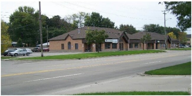
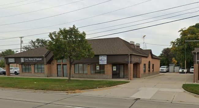
Property Record
26110 Harper Ave, Saint Clair Shores, MI 48081

Current Lease Availabilities
NEARBY LISTINGS FOR SALE OR LEASE
Property Detail
26110 Harper Ave
Detroit-Warren-Dearborn, MI
Heights Annex Sub
09-14-22-334-001
STATLER HEIGHTS ANNEX SUB'N (L7, P54) LOTS 1-3 ALSO LOTS 46-53 OF ANSONIA GARDENS SUB'N AND W 1/2 OF VAC ALLEY LYING ADJ TO
Medicalbuilding
Macomb
X
Michigan
26163C0135F
46-53,1
2025
0.79 AC
2025
Macomb East
251200
Detroit
9,884 SF
DEMOGRAPHICS near 26110 Harper Ave
1 Mile
3 Mile
5 Mile
2024 Total Population
15,226
104,394
247,587
2029 Population
14,952
102,577
243,450
Pop Growth 2024-2029
(1.80%)
(1.74%)
(1.67%)
Average Age
44
42
40
2024 Total Households
6,764
44,894
101,609
HH Growth 2024-2029
(1.92%)
(1.82%)
(1.72%)
Median Household Inc
$71,997
$63,076
$60,743
Avg Household Size
2.20
2.30
2.40
2024 Avg HH Vehicles
2.00
2.00
2.00
Median Home Value
$170,852
$155,500
$150,675
Median Year Built
1955
1956
1957
Nearby Places
Map Layers
Map Styles
 Street
 Aerial
- Restaurants
- Banks
- Shops
- Fitness
- Groceries
PUBLIC TRANSPORTATION
AIRPORT
Windsor International
DRIVE
WALK
Distance
Windsor International
48 min
24.8 mi
Detroit Metro Wayne County
DRIVE
WALK
Distance
Detroit Metro Wayne County
51 min
34.3 mi
Nearby Properties
Address
Land Use
TOTAL SIZE
Lot Size
Zoning
Address
Land Use
TOTAL SIZE
Lot Size
Zoning
9,937 SF
35.42 AC
CLD
Address
Land Use
TOTAL SIZE
Lot Size
Zoning
153,882 SF
5.65 AC
RA
Address
Land Use
TOTAL SIZE
Lot Size
Zoning
236,221 SF
31.30 AC
B-2
Address
Land Use
TOTAL SIZE
Lot Size
Zoning
91,386 SF
B-2
Address
Land Use
TOTAL SIZE
Lot Size
Zoning
89,970 SF
2.86 AC
RM-1
Address
Land Use
TOTAL SIZE
Lot Size
Zoning
192,387 SF
11.26 AC
CLD
Address
Land Use
TOTAL SIZE
Lot Size
Zoning
217,369 SF
20.15 AC
B-2
Address
Land Use
TOTAL SIZE
Lot Size
Zoning
129,502 SF
3.17 AC
RM-1
Address
Land Use
TOTAL SIZE
Lot Size
Zoning
179,653 SF
11.56 AC
B-2
Address
Land Use
TOTAL SIZE
Lot Size
Zoning
103,069 SF
11.41 AC
B-3
Address
Land Use
TOTAL SIZE
Lot Size
Zoning
41,065 SF
4.30 AC
B-3
Address
Land Use
TOTAL SIZE
Lot Size
Zoning
105,354 SF
2.33 AC
B-3
Address
Land Use
TOTAL SIZE
Lot Size
Zoning
115,307 SF
7.01 AC
RM-1
Address
Land Use
TOTAL SIZE
Lot Size
Zoning
178,358 SF
12.41 AC
B-2
Address
Land Use
TOTAL SIZE
Lot Size
Zoning
75,284 SF
0.87 AC
C
Address
Land Use
TOTAL SIZE
Lot Size
Zoning
167,589 SF
16.80 AC
B-3
Address
Land Use
TOTAL SIZE
Lot Size
Zoning
202,788 SF
27.98 AC
CLD
Address
Land Use
TOTAL SIZE
Lot Size
Zoning
91,386 SF
8.61 AC
B-2
Address
Land Use
TOTAL SIZE
Lot Size
Zoning
119,898 SF
14.65 AC
B-2
Address
Land Use
TOTAL SIZE
Lot Size
Zoning
133,611 SF
11.74 AC
B-3
Address
Land Use
TOTAL SIZE
Lot Size
Zoning
5,511 SF
1.52 AC
Address
Land Use
TOTAL SIZE
Lot Size
Zoning
87,747 SF
6.41 AC
RM-1
Address
Land Use
TOTAL SIZE
Lot Size
Zoning
136,270 SF
3.42 AC
LI
Address
Land Use
TOTAL SIZE
Lot Size
Zoning
65,412 SF
B-3
Address
Land Use
TOTAL SIZE
Lot Size
Zoning
143,568 SF
6.41 AC
B-2
Address
Land Use
TOTAL SIZE
Lot Size
Zoning
91,739 SF
6.54 AC
B-2
Address
Land Use
TOTAL SIZE
Lot Size
Zoning
103,616 SF
11.10 AC
B-3
Address
Land Use
TOTAL SIZE
Lot Size
Zoning
148,932 SF
12.38 AC
B-2
Address
Land Use
TOTAL SIZE
Lot Size
Zoning
30,244 SF
2.06 AC
B-1
Address
Land Use
TOTAL SIZE
Lot Size
Zoning
28,300 SF
11.49 AC
I-1
The World's #1 Commercial Real Estate Marketplace
Connect with us
© 2025 CoStar Group
The information above has been obtained from sources believed reliable. While we do not doubt its accuracy we have not verified it and make no guarantee, warranty or representation about it. It is your responsibility to independently confirm its accuracy and completeness. Any projections, opinions, assumptions, or estimates used are for example only and do not represent the current or future performance of the property. The value of this transaction to you depends on tax and other factors which should be evaluated by your tax, financial, and legal advisors. You and your advisors should conduct a careful, independent investigation of the property to determine to your satisfaction the suitability of the property for your needs.