Property Record
2605 Broad St, Riverton, NJ 08077


Save to a Folder
{{folder.Name}}
{{folder.ListingIds.length}} Properties
{{folder.ListingIds.length}} Property
Create a New Folder
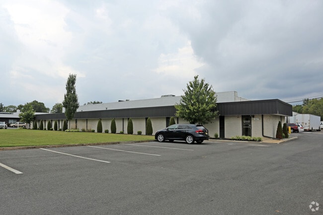
Property Detail
2605 Broad St
Philadelphia-Camden-Wilmington, PA-NJ-DE-MD
ADDITIONAL LOTS: 51432 SF
08-00202-0000-00001
BURLINGTON
Industrialgeneral
New Jersey
AE The base floodplain where base flood elevations are provided. AE Zones are now used on new format FIRMs instead of A1-A30 Zones.
1
2025
4.17 AC
2026
Burlington
700303
Philadelphia
NEARBY LISTINGS FOR SALE OR LEASE
DEMOGRAPHICS near 2605 Broad St
1 mile
3 mile
5 mile
2025 Total Population
2,960
109,415
375,299
2030 Population
3,093
109,057
370,675
Pop Growth 2025-2030
+ 4.49%
(0.33%)
(1.23%)
Average Age
39
41
40
2025 Total Households
1,229
42,092
139,883
HH Growth 2025-2030
+ 4.64%
(0.48%)
(1.26%)
Median Household Inc
$93,504
$83,967
$70,794
Avg Household Size
2.40
2.50
2.60
2025 Avg HH Vehicles
2.00
2.00
2.00
Median Home Value
$347,368
$272,597
$261,771
Median Year Built
2009
1958
1958
Nearby Places
Map Layers
Map Styles
 Street
 Aerial
Layers
 Traffic
 Biking
Places
Listings with unknown addresses are not visible on the map
- Restaurants
- Banks
- Shops
- Fitness
- Groceries
PUBLIC TRANSPORTATION
TRANSIT/SUBWAY
Cinnaminson (River LINE - River LINE (River LINE))
Drive
Walk
Distance
Cinnaminson (River LINE - River LINE (River LINE))
2 min
11 min
0.6 mi
COMMUTER RAIL
Cherry Hill (Atlantic City Line - NJ Transit Commuter Rail (NJ Transit))
Drive
Walk
Distance
Cherry Hill (Atlantic City Line - NJ Transit Commuter Rail (NJ Transit))
26 min
9.9 mi
AIRPORT
Philadelphia International
Drive
Walk
Distance
Philadelphia International
36 min
23.8 mi
SALE & LEASE HISTORY
LISTING DATE
SALE/LEASE

Dec 20, 2016
For Lease
Nearby Properties
Address
Land Use
TOTAL SIZE
Lot Size
Zoning
Address
Land Use
TOTAL SIZE
Lot Size
Zoning
597,188 SF
120.50 AC
RM2
Address
Land Use
TOTAL SIZE
Lot Size
Zoning
95,280 SF
117.33 AC
I3
Address
Land Use
TOTAL SIZE
Lot Size
Zoning
54.54 AC
Address
Land Use
TOTAL SIZE
Lot Size
Zoning
37.21 AC
SPPOA
Address
Land Use
TOTAL SIZE
Lot Size
Zoning
50.73 AC
C73A
Address
Land Use
TOTAL SIZE
Lot Size
Zoning
2,550 SF
63.76 AC
SPPOA
Address
Land Use
TOTAL SIZE
Lot Size
Zoning
95.79 AC
Address
Land Use
TOTAL SIZE
Lot Size
Zoning
251,791 SF
15.59 AC
I2
Address
Land Use
TOTAL SIZE
Lot Size
Zoning
228,652 SF
12.81 AC
I1
Address
Land Use
TOTAL SIZE
Lot Size
Zoning
5.70 AC
R2
Address
Land Use
TOTAL SIZE
Lot Size
Zoning
437,192 SF
28.03 AC
I2
Address
Land Use
TOTAL SIZE
Lot Size
Zoning
22.49 AC
Address
Land Use
TOTAL SIZE
Lot Size
Zoning
27.33 AC
Address
Land Use
TOTAL SIZE
Lot Size
Zoning
82.32 AC
Address
Land Use
TOTAL SIZE
Lot Size
Zoning
3.59 AC
Address
Land Use
TOTAL SIZE
Lot Size
Zoning
39.53 AC
Address
Land Use
TOTAL SIZE
Lot Size
Zoning
19 AC
Address
Land Use
TOTAL SIZE
Lot Size
Zoning
150.59 AC
Address
Land Use
TOTAL SIZE
Lot Size
Zoning
154,540 SF
4.34 AC
I1
Address
Land Use
TOTAL SIZE
Lot Size
Zoning
24.56 AC
Address
Land Use
TOTAL SIZE
Lot Size
Zoning
205,472 SF
8.40 AC
RM2
Address
Land Use
TOTAL SIZE
Lot Size
Zoning
112,440 SF
10.58 AC
CA1
Address
Land Use
TOTAL SIZE
Lot Size
Zoning
88,320 SF
21.03 AC
SPINS
Address
Land Use
TOTAL SIZE
Lot Size
Zoning
20.30 AC
Address
Land Use
TOTAL SIZE
Lot Size
Zoning
19.97 AC
Address
Land Use
TOTAL SIZE
Lot Size
Zoning
39.58 AC
Address
Land Use
TOTAL SIZE
Lot Size
Zoning
206,982 SF
8.32 AC
I2
Address
Land Use
TOTAL SIZE
Lot Size
Zoning
208,527 SF
7.80 AC
RM2
Address
Land Use
TOTAL SIZE
Lot Size
Zoning
25,842 SF
3.87 AC
RSA5
Address
Land Use
TOTAL SIZE
Lot Size
Zoning
152,835 SF
4.46 AC
RM2
The World's #1 Commercial Real Estate Marketplace
Connect with us
© 2026 CoStar Group
The information above has been obtained from sources believed reliable. While we do not doubt its accuracy we have not verified it and make no guarantee, warranty or representation about it. It is your responsibility to independently confirm its accuracy and completeness. Any projections, opinions, assumptions, or estimates used are for example only and do not represent the current or future performance of the property. The value of this transaction to you depends on tax and other factors which should be evaluated by your tax, financial, and legal advisors. You and your advisors should conduct a careful, independent investigation of the property to determine to your satisfaction the suitability of the property for your needs.