Property Record
393 S Hwy, La Grange, KY 40031
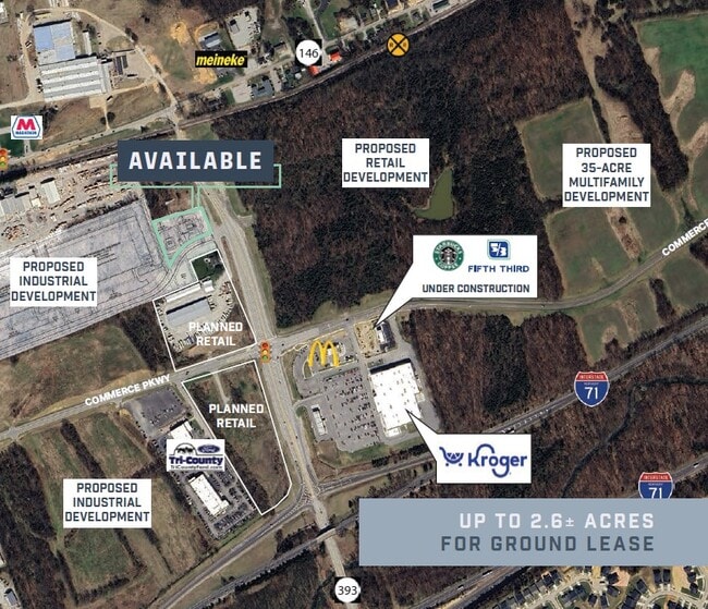
Current Lease Availabilities
NEARBY LISTINGS FOR SALE OR LEASE
Property Detail
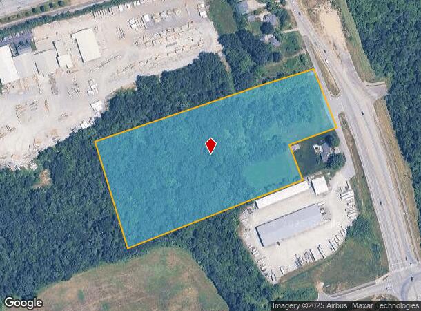
393 S Hwy
Louisville-Jefferson County, KY-IN
Stone Rdg Sec 1
31-00-00-8A
10.27AC
Commercialacreage
Oldham
X
Kentucky
21185C0120E
8a
2024
10.27 AC
2024
Oldham County
030301
Louisville
DEMOGRAPHICS near 393 S Hwy
1 Mile
3 Mile
5 Mile
2024 Total Population
2,299
16,879
42,337
2029 Population
2,478
18,550
46,849
Pop Growth 2024-2029
+ 7.79%
+ 9.90%
+ 10.66%
Average Age
44
42
40
2024 Total Households
443
4,727
13,594
HH Growth 2024-2029
+ 12.19%
+ 11.99%
+ 11.73%
Median Household Inc
$128,879
$122,637
$109,522
Avg Household Size
2.90
2.80
2.80
2024 Avg HH Vehicles
2.00
2.00
2.00
Median Home Value
$371,333
$366,896
$366,666
Median Year Built
1990
1993
1994
Nearby Places
- Restaurants
- Banks
- Shops
- Fitness
- Groceries
PUBLIC TRANSPORTATION
AIRPORT
Louisville Muhammad Ali International
DRIVE
WALK
Distance
Louisville Muhammad Ali International
39 min
27.5 mi
Freight Ports
Port of Toledo
DRIVE
WALK
Distance
Port of Toledo
328 min
284.5 mi
Nearby Properties
Address
Land Use
TOTAL SIZE
Lot Size
Zoning
Address
Land Use
TOTAL SIZE
Lot Size
Zoning
85.51 AC
Address
Land Use
TOTAL SIZE
Lot Size
Zoning
67.01 AC
Address
Land Use
TOTAL SIZE
Lot Size
Zoning
56.97 AC
Address
Land Use
TOTAL SIZE
Lot Size
Zoning
Address
Land Use
TOTAL SIZE
Lot Size
Zoning
13.54 AC
Address
Land Use
TOTAL SIZE
Lot Size
Zoning
33.71 AC
Address
Land Use
TOTAL SIZE
Lot Size
Zoning
Address
Land Use
TOTAL SIZE
Lot Size
Zoning
3.29 AC
Address
Land Use
TOTAL SIZE
Lot Size
Zoning
25.49 AC
Address
Land Use
TOTAL SIZE
Lot Size
Zoning
105,000 SF
45.85 AC
Address
Land Use
TOTAL SIZE
Lot Size
Zoning
9.58 AC
Address
Land Use
TOTAL SIZE
Lot Size
Zoning
295.27 AC
Address
Land Use
TOTAL SIZE
Lot Size
Zoning
2.08 AC
Address
Land Use
TOTAL SIZE
Lot Size
Zoning
7.95 AC
Address
Land Use
TOTAL SIZE
Lot Size
Zoning
75.21 AC
Address
Land Use
TOTAL SIZE
Lot Size
Zoning
48.82 AC
Address
Land Use
TOTAL SIZE
Lot Size
Zoning
8.51 AC
Address
Land Use
TOTAL SIZE
Lot Size
Zoning
176.02 AC
Address
Land Use
TOTAL SIZE
Lot Size
Zoning
54.49 AC
Address
Land Use
TOTAL SIZE
Lot Size
Zoning
20.97 AC
Address
Land Use
TOTAL SIZE
Lot Size
Zoning
Address
Land Use
TOTAL SIZE
Lot Size
Zoning
168 AC
Address
Land Use
TOTAL SIZE
Lot Size
Zoning
Address
Land Use
TOTAL SIZE
Lot Size
Zoning
21.37 AC
Address
Land Use
TOTAL SIZE
Lot Size
Zoning
10.43 AC
Address
Land Use
TOTAL SIZE
Lot Size
Zoning
Address
Land Use
TOTAL SIZE
Lot Size
Zoning
15.83 AC
Address
Land Use
TOTAL SIZE
Lot Size
Zoning
2.65 AC
Address
Land Use
TOTAL SIZE
Lot Size
Zoning
4.21 AC
Address
Land Use
TOTAL SIZE
Lot Size
Zoning
The World's #1 Commercial Real Estate Marketplace
Connect with us
© 2025 CoStar Group
The information above has been obtained from sources believed reliable. While we do not doubt its accuracy we have not verified it and make no guarantee, warranty or representation about it. It is your responsibility to independently confirm its accuracy and completeness. Any projections, opinions, assumptions, or estimates used are for example only and do not represent the current or future performance of the property. The value of this transaction to you depends on tax and other factors which should be evaluated by your tax, financial, and legal advisors. You and your advisors should conduct a careful, independent investigation of the property to determine to your satisfaction the suitability of the property for your needs.