Property Record
2605 Old 421 Rd, Staley, NC 27355
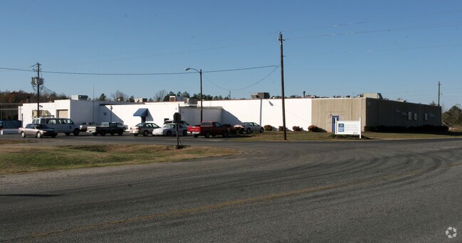

Property Detail
2605 Old 421 Rd
8735-50-3155
OLD 421;W
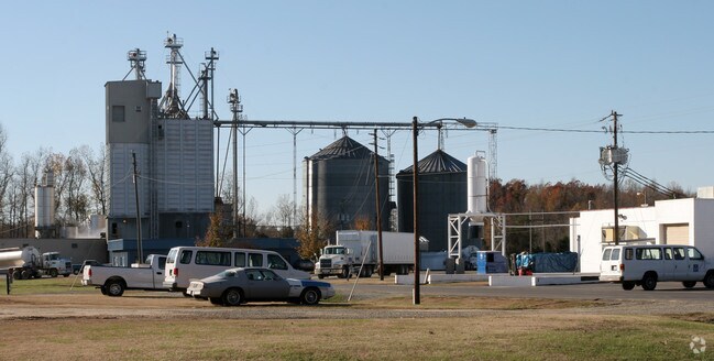
Warehouse
RANDOLPH
LI
North Carolina
B and X Area of moderate flood hazard, usually the area between the limits of the 100-year and 500-year floods.
64.31 AC
2025
NE Randolph County
2025
Greensboro/Winston-Salem
031002
Greensboro-High Point, NC
20,927 SF
NEARBY LISTINGS FOR SALE OR LEASE
-
-
View all Staley listings for sale on LoopNet.com
DEMOGRAPHICS near 2605 Old 421 Rd
1 mile
3 mile
5 mile
2025 Total Population
513
3,450
8,355
2030 Population
524
3,522
8,570
Pop Growth 2025-2030
+ 2.14%
+ 2.09%
+ 2.57%
Average Age
42
42
42
2025 Total Households
209
1,400
3,383
HH Growth 2025-2030
+ 2.39%
+ 2.14%
+ 2.66%
Median Household Inc
$65,000
$59,642
$54,931
Avg Household Size
2.40
2.40
2.40
2025 Avg HH Vehicles
2.00
2.00
2.00
Median Home Value
$176,388
$192,856
$201,644
Median Year Built
1981
1980
1981
Nearby Places
Map Layers
Map Styles
 Street
 Aerial
Layers
 Traffic
 Biking
Places
Listings with unknown addresses are not visible on the map
- Restaurants
- Banks
- Shops
- Fitness
- Groceries
PUBLIC TRANSPORTATION
AIRPORT
Piedmont Triad International
Drive
Walk
Distance
Piedmont Triad International
47 min
33.6 mi
Freight Ports
Port of Wilmington
Drive
Walk
Distance
Port of Wilmington
218 min
160.8 mi
Nearby Properties
Address
Land Use
TOTAL SIZE
Lot Size
Zoning
Address
Land Use
TOTAL SIZE
Lot Size
Zoning
89,754 SF
9.01 AC
IP
Address
Land Use
TOTAL SIZE
Lot Size
Zoning
89,754 SF
9.01 AC
I-P
Address
Land Use
TOTAL SIZE
Lot Size
Zoning
87,544 SF
11.89 AC
I-P
Address
Land Use
TOTAL SIZE
Lot Size
Zoning
64,444 SF
28.59 AC
I
Address
Land Use
TOTAL SIZE
Lot Size
Zoning
87,544 SF
11.95 AC
IP
Address
Land Use
TOTAL SIZE
Lot Size
Zoning
4,884 SF
9.20 AC
I
Address
Land Use
TOTAL SIZE
Lot Size
Zoning
12,000 SF
16.70 AC
HC-CD
Address
Land Use
TOTAL SIZE
Lot Size
Zoning
51,464 SF
19.12 AC
I
Address
Land Use
TOTAL SIZE
Lot Size
Zoning
24,740 SF
32.95 AC
I
Address
Land Use
TOTAL SIZE
Lot Size
Zoning
1,460 SF
19.87 AC
LI
Address
Land Use
TOTAL SIZE
Lot Size
Zoning
14,284 SF
5.01 AC
I
Address
Land Use
TOTAL SIZE
Lot Size
Zoning
24,950 SF
14.10 AC
LI
Address
Land Use
TOTAL SIZE
Lot Size
Zoning
6,636 SF
2.76 AC
RR
Address
Land Use
TOTAL SIZE
Lot Size
Zoning
7,038 SF
3.73 AC
RR
Address
Land Use
TOTAL SIZE
Lot Size
Zoning
4,000 SF
84.80 AC
R-1
Address
Land Use
TOTAL SIZE
Lot Size
Zoning
17,725 SF
1.81 AC
B-2
Address
Land Use
TOTAL SIZE
Lot Size
Zoning
9,000 SF
5.78 AC
M1
Address
Land Use
TOTAL SIZE
Lot Size
Zoning
3.10 AC
B-2
Address
Land Use
TOTAL SIZE
Lot Size
Zoning
6,692 SF
23.65 AC
R-5
Address
Land Use
TOTAL SIZE
Lot Size
Zoning
20,000 SF
6.36 AC
LI
Address
Land Use
TOTAL SIZE
Lot Size
Zoning
38.41 AC
RA
Address
Land Use
TOTAL SIZE
Lot Size
Zoning
18,720 SF
9.68 AC
I-P
Address
Land Use
TOTAL SIZE
Lot Size
Zoning
100 AC
R-5
Address
Land Use
TOTAL SIZE
Lot Size
Zoning
4,284 SF
5.04 AC
RBO-CD
Address
Land Use
TOTAL SIZE
Lot Size
Zoning
23,820 SF
8 AC
LI
Address
Land Use
TOTAL SIZE
Lot Size
Zoning
8,888 SF
22.10 AC
HC
Address
Land Use
TOTAL SIZE
Lot Size
Zoning
3,848 SF
56.48 AC
R-1
Address
Land Use
TOTAL SIZE
Lot Size
Zoning
7,416 SF
1.93 AC
RR
Address
Land Use
TOTAL SIZE
Lot Size
Zoning
18,820 SF
1.34 AC
B-2
The World's #1 Commercial Real Estate Marketplace
Connect with us
© 2026 CoStar Group
The information above has been obtained from sources believed reliable. While we do not doubt its accuracy we have not verified it and make no guarantee, warranty or representation about it. It is your responsibility to independently confirm its accuracy and completeness. Any projections, opinions, assumptions, or estimates used are for example only and do not represent the current or future performance of the property. The value of this transaction to you depends on tax and other factors which should be evaluated by your tax, financial, and legal advisors. You and your advisors should conduct a careful, independent investigation of the property to determine to your satisfaction the suitability of the property for your needs.