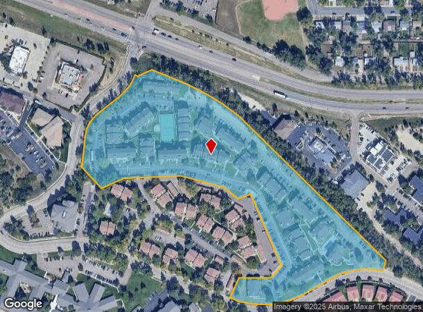
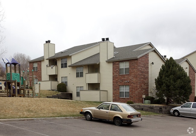
Property Record
2605 Reeve Cir, Colorado Springs, CO 80906

NEARBY LISTINGS FOR SALE OR LEASE
Property Detail
2605 Reeve Cir
Colorado Springs, CO
The Summit
64322-04-057
LOT 1 BLK 1 THE SUMMIT COLO SPGS
Charitableorganization
El Paso
X
Colorado
08041C0741G
1
0
11.59 AC
2025
Cheyenne Hills
003303
Colorado Springs
215,464 SF
DEMOGRAPHICS near 2605 Reeve Cir
1 Mile
3 Mile
5 Mile
2024 Total Population
10,787
86,006
221,073
2029 Population
11,346
90,193
231,307
Pop Growth 2024-2029
+ 5.18%
+ 4.87%
+ 4.63%
Average Age
40
38
37
2024 Total Households
4,961
36,030
87,830
HH Growth 2024-2029
+ 5.32%
+ 5.17%
+ 4.97%
Median Household Inc
$54,530
$59,349
$59,320
Avg Household Size
2.10
2.30
2.30
2024 Avg HH Vehicles
1.00
2.00
2.00
Median Home Value
$321,099
$373,251
$342,549
Median Year Built
1976
1979
1977
Nearby Places
Map Layers
Map Styles
 Street
 Aerial
- Restaurants
- Banks
- Shops
- Fitness
- Groceries
PUBLIC TRANSPORTATION
AIRPORT
City of Colorado Springs Municipal
DRIVE
WALK
Distance
City of Colorado Springs Municipal
22 min
9.9 mi
Nearby Properties
Address
Land Use
TOTAL SIZE
Lot Size
Zoning
Address
Land Use
TOTAL SIZE
Lot Size
Zoning
309,046 SF
28.95 AC
PF SS
Address
Land Use
TOTAL SIZE
Lot Size
Zoning
152,977 SF
39.50 AC
MX-M MX-M/
Address
Land Use
TOTAL SIZE
Lot Size
Zoning
123,725 SF
1.57 AC
FBZ-CEN
Address
Land Use
TOTAL SIZE
Lot Size
Zoning
151,674 SF
1.21 AC
FBZ-CEN
Address
Land Use
TOTAL SIZE
Lot Size
Zoning
217,459 SF
3.67 AC
FBZ-CEN UV
Address
Land Use
TOTAL SIZE
Lot Size
Zoning
226,707 SF
3.25 AC
PF UV
Address
Land Use
TOTAL SIZE
Lot Size
Zoning
168,835 SF
33 AC
PF SS
Address
Land Use
TOTAL SIZE
Lot Size
Zoning
215,377 SF
11.24 AC
R-5/CR
Address
Land Use
TOTAL SIZE
Lot Size
Zoning
983,639 SF
43.31 AC
MX-M CU HR
Address
Land Use
TOTAL SIZE
Lot Size
Zoning
51,766 SF
4.53 AC
FBZ-CEN
Address
Land Use
TOTAL SIZE
Lot Size
Zoning
130,451 SF
0.66 AC
FBZ-CEN
Address
Land Use
TOTAL SIZE
Lot Size
Zoning
109,739 SF
18.61 AC
BP/CR CU
Address
Land Use
TOTAL SIZE
Lot Size
Zoning
123,644 SF
74.14 AC
GI PF SS
Address
Land Use
TOTAL SIZE
Lot Size
Zoning
420,063 SF
2.31 AC
FBZ-CEN
Address
Land Use
TOTAL SIZE
Lot Size
Zoning
50,519 SF
1.66 AC
FBZ-CEN
Address
Land Use
TOTAL SIZE
Lot Size
Zoning
1,294,065 SF
3.78 AC
FBZ-CEN
Address
Land Use
TOTAL SIZE
Lot Size
Zoning
70,985 SF
0.65 AC
FBZ-CEN
Address
Land Use
TOTAL SIZE
Lot Size
Zoning
113,594 SF
1.65 AC
R-5 HR
Address
Land Use
TOTAL SIZE
Lot Size
Zoning
98,647 SF
9.50 AC
PDZ MX-N/C
Address
Land Use
TOTAL SIZE
Lot Size
Zoning
49,031 SF
69.16 AC
PCR HS
Address
Land Use
TOTAL SIZE
Lot Size
Zoning
99,750 SF
0.92 AC
FBZ-CEN UV
Address
Land Use
TOTAL SIZE
Lot Size
Zoning
71,438 SF
9.81 AC
R-5/CR
Address
Land Use
TOTAL SIZE
Lot Size
Zoning
244,545 SF
1.14 AC
FBZ-CEN
Address
Land Use
TOTAL SIZE
Lot Size
Zoning
65,400 SF
13.65 AC
PF CU
Address
Land Use
TOTAL SIZE
Lot Size
Zoning
47,870 SF
0.72 AC
FBZ-COR SS
Address
Land Use
TOTAL SIZE
Lot Size
Zoning
125,685 SF
1.28 AC
FBZ-T1
Address
Land Use
TOTAL SIZE
Lot Size
Zoning
75,958 SF
0.96 AC
PK R-5 HR
Address
Land Use
TOTAL SIZE
Lot Size
Zoning
58,105 SF
3.67 AC
PK
Address
Land Use
TOTAL SIZE
Lot Size
Zoning
601,737 SF
7.24 AC
MX-M
The World's #1 Commercial Real Estate Marketplace
Connect with us
© 2026 CoStar Group
The information above has been obtained from sources believed reliable. While we do not doubt its accuracy we have not verified it and make no guarantee, warranty or representation about it. It is your responsibility to independently confirm its accuracy and completeness. Any projections, opinions, assumptions, or estimates used are for example only and do not represent the current or future performance of the property. The value of this transaction to you depends on tax and other factors which should be evaluated by your tax, financial, and legal advisors. You and your advisors should conduct a careful, independent investigation of the property to determine to your satisfaction the suitability of the property for your needs.