Property Record
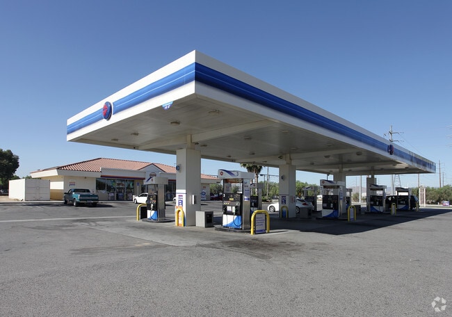
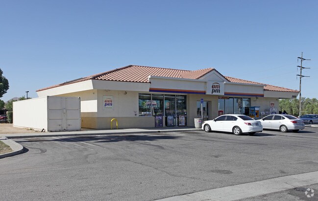
26050 Menifee Rd, Menifee, CA 92585

Property Detail
26050 Menifee Rd
331-260-017
2.14 ACRES M/L IN POR LOT 97 MB 013/020 ROMOLA FARMS 2
Servicestation
RIVERSIDE
RR
California
A Areas with a 1% annual chance of flooding and a 26% chance of flooding over the life of a 30-year mortgage.
97
2024
2.14 AC
2025
South Riverside
042726
Inland Empire (California)
2,992 SF
Riverside-San Bernardino-Ontario, CA
NEARBY LISTINGS FOR SALE OR LEASE
DEMOGRAPHICS near 26050 Menifee Rd
1 mile
3 mile
5 mile
2025 Total Population
2,423
41,104
115,924
2030 Population
2,493
42,908
120,972
Pop Growth 2025-2030
+ 2.89%
+ 4.39%
+ 4.35%
Average Age
36
39
40
2025 Total Households
628
12,850
37,508
HH Growth 2025-2030
+ 2.71%
+ 3.90%
+ 3.76%
Median Household Inc
$85,149
$82,598
$81,311
Avg Household Size
3.60
3.10
3.00
2025 Avg HH Vehicles
3.00
2.00
2.00
Median Home Value
$607,605
$494,808
$501,265
Median Year Built
1988
1999
1996
Nearby Places
Map Layers
Map Styles
 Street
 Aerial
Layers
 Traffic
 Biking
Places
Listings with unknown addresses are not visible on the map
- Restaurants
- Banks
- Shops
- Fitness
- Groceries
PUBLIC TRANSPORTATION
COMMUTER RAIL
South Perris (Metrolink 91-Perris Valley Line - Metrolink Trains)
Drive
Walk
Distance
South Perris (Metrolink 91-Perris Valley Line - Metrolink Trains)
6 min
3.6 mi
Perris Downtown (Metrolink 91-Perris Valley Line - Metrolink Trains)
Drive
Walk
Distance
Perris Downtown (Metrolink 91-Perris Valley Line - Metrolink Trains)
10 min
6.3 mi
Freight Ports
Port of Long Beach
Drive
Walk
Distance
Port of Long Beach
99 min
74.2 mi
Nearby Properties
Address
Land Use
TOTAL SIZE
Lot Size
Zoning
Address
Land Use
TOTAL SIZE
Lot Size
Zoning
123,058 SF
17.09 AC
R3
Address
Land Use
TOTAL SIZE
Lot Size
Zoning
9.22 AC
CBOOK
Address
Land Use
TOTAL SIZE
Lot Size
Zoning
40,349 SF
9.89 AC
R3
Address
Land Use
TOTAL SIZE
Lot Size
Zoning
104,208 SF
10.96 AC
Address
Land Use
TOTAL SIZE
Lot Size
Zoning
13.95 AC
Address
Land Use
TOTAL SIZE
Lot Size
Zoning
97,942 SF
11 AC
Address
Land Use
TOTAL SIZE
Lot Size
Zoning
86,590 SF
10.97 AC
MM
Address
Land Use
TOTAL SIZE
Lot Size
Zoning
27,252 SF
5.42 AC
R6
Address
Land Use
TOTAL SIZE
Lot Size
Zoning
41,840 SF
8.92 AC
Address
Land Use
TOTAL SIZE
Lot Size
Zoning
24,889 SF
42.36 AC
Address
Land Use
TOTAL SIZE
Lot Size
Zoning
29,598 SF
3.26 AC
Address
Land Use
TOTAL SIZE
Lot Size
Zoning
59,066 SF
4.80 AC
C1CP
Address
Land Use
TOTAL SIZE
Lot Size
Zoning
70,680 SF
4.59 AC
M-M
Address
Land Use
TOTAL SIZE
Lot Size
Zoning
68,986 SF
7.21 AC
CPS
Address
Land Use
TOTAL SIZE
Lot Size
Zoning
13,808 SF
2.82 AC
R2
Address
Land Use
TOTAL SIZE
Lot Size
Zoning
11,200 SF
11.05 AC
MM
Address
Land Use
TOTAL SIZE
Lot Size
Zoning
54,282 SF
3.87 AC
MSC
Address
Land Use
TOTAL SIZE
Lot Size
Zoning
6,100 SF
3.14 AC
Address
Land Use
TOTAL SIZE
Lot Size
Zoning
3,275 SF
7.79 AC
Address
Land Use
TOTAL SIZE
Lot Size
Zoning
1,936 SF
4.06 AC
Address
Land Use
TOTAL SIZE
Lot Size
Zoning
4.43 AC
SPZONE
Address
Land Use
TOTAL SIZE
Lot Size
Zoning
45,640 SF
10.01 AC
MM
The World's #1 Commercial Real Estate Marketplace
Connect with us
© 2026 CoStar Group
The information above has been obtained from sources believed reliable. While we do not doubt its accuracy we have not verified it and make no guarantee, warranty or representation about it. It is your responsibility to independently confirm its accuracy and completeness. Any projections, opinions, assumptions, or estimates used are for example only and do not represent the current or future performance of the property. The value of this transaction to you depends on tax and other factors which should be evaluated by your tax, financial, and legal advisors. You and your advisors should conduct a careful, independent investigation of the property to determine to your satisfaction the suitability of the property for your needs.