Property Record
26051 Dequindre Rd, Madison Heights, MI 48071


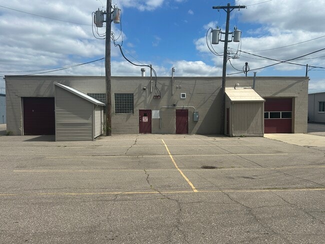
This Property Is For Sale
NEARBY LISTINGS FOR SALE OR LEASE
Property Detail
26051 Dequindre Rd
Warehouse
T1N, R11E, SEC 24 PART OF NE 1/4 BEG AT PT DIST N 01-57-03 W 43 FT & S 87-49-59 W 292.97 FT & N 01-58-41 W 391.49 FT FROM E
X
Oakland
26163C0125E
Michigan
2024
Royal Oak
2025
Detroit
181600
Detroit-Warren-Dearborn, MI
8,000 SF
25-24-251-036
DEMOGRAPHICS near 26051 Dequindre Rd
1 Mile
3 Mile
5 Mile
2024 Total Population
12,991
121,393
332,050
2029 Population
12,791
120,346
329,814
Pop Growth 2024-2029
(1.54%)
(0.86%)
(0.67%)
Average Age
41
40
40
2024 Total Households
5,908
53,507
142,866
HH Growth 2024-2029
(1.52%)
(0.86%)
(0.68%)
Median Household Inc
$46,960
$61,280
$60,414
Avg Household Size
2.10
2.20
2.30
2024 Avg HH Vehicles
1.00
2.00
2.00
Median Home Value
$141,073
$165,152
$176,106
Median Year Built
1964
1958
1957
Nearby Places
Map Layers
Map Styles
 Street
 Aerial
- Restaurants
- Banks
- Shops
- Fitness
- Groceries
PUBLIC TRANSPORTATION
COMMUTER RAIL
DRIVE
WALK
Distance
8 min
4.3 mi
DRIVE
WALK
Distance
17 min
9.3 mi
AIRPORT
Windsor International
DRIVE
WALK
Distance
Windsor International
40 min
22.4 mi
Detroit Metro Wayne County
DRIVE
WALK
Distance
Detroit Metro Wayne County
44 min
32.0 mi
Nearby Properties
Address
Land Use
TOTAL SIZE
Lot Size
Zoning
Address
Land Use
TOTAL SIZE
Lot Size
Zoning
1,727,664 SF
167.66 AC
M-3
Address
Land Use
TOTAL SIZE
Lot Size
Zoning
322,580 SF
Address
Land Use
TOTAL SIZE
Lot Size
Zoning
4.20 AC
REG BUS
Address
Land Use
TOTAL SIZE
Lot Size
Zoning
910,140 SF
47.78 AC
Address
Land Use
TOTAL SIZE
Lot Size
Zoning
419,600 SF
Address
Land Use
TOTAL SIZE
Lot Size
Zoning
649,140 SF
43.98 AC
Address
Land Use
TOTAL SIZE
Lot Size
Zoning
207,605 SF
20.56 AC
PUD
Address
Land Use
TOTAL SIZE
Lot Size
Zoning
576,924 SF
31.35 AC
Address
Land Use
TOTAL SIZE
Lot Size
Zoning
1,150,792 SF
53.17 AC
AD
Address
Land Use
TOTAL SIZE
Lot Size
Zoning
674,395 SF
33.13 AC
M-3
Address
Land Use
TOTAL SIZE
Lot Size
Zoning
157,004 SF
1.78 AC
PUD
Address
Land Use
TOTAL SIZE
Lot Size
Zoning
228,421 SF
17.18 AC
RMMUL
Address
Land Use
TOTAL SIZE
Lot Size
Zoning
306,345 SF
Address
Land Use
TOTAL SIZE
Lot Size
Zoning
455,425 SF
Address
Land Use
TOTAL SIZE
Lot Size
Zoning
348,256 SF
46.10 AC
MZ
Address
Land Use
TOTAL SIZE
Lot Size
Zoning
576,924 SF
36.24 AC
Address
Land Use
TOTAL SIZE
Lot Size
Zoning
146,981 SF
4.11 AC
Address
Land Use
TOTAL SIZE
Lot Size
Zoning
207,605 SF
19.39 AC
RETAIL5KSF
Address
Land Use
TOTAL SIZE
Lot Size
Zoning
378,412 SF
M1LT
Address
Land Use
TOTAL SIZE
Lot Size
Zoning
198,064 SF
11.11 AC
MZ
Address
Land Use
TOTAL SIZE
Lot Size
Zoning
150,703 SF
Address
Land Use
TOTAL SIZE
Lot Size
Zoning
1,261,658 SF
71.94 AC
M-2
Address
Land Use
TOTAL SIZE
Lot Size
Zoning
132,512 SF
0.50 AC
CBD
Address
Land Use
TOTAL SIZE
Lot Size
Zoning
233,900 SF
15.56 AC
M-2
Address
Land Use
TOTAL SIZE
Lot Size
Zoning
Address
Land Use
TOTAL SIZE
Lot Size
Zoning
272,046 SF
17.63 AC
M-2
Address
Land Use
TOTAL SIZE
Lot Size
Zoning
171,259 SF
1.26 AC
CBD
Address
Land Use
TOTAL SIZE
Lot Size
Zoning
362,895 SF
14.85 AC
M-2
Address
Land Use
TOTAL SIZE
Lot Size
Zoning
259,959 SF
27.39 AC
MZ
Address
Land Use
TOTAL SIZE
Lot Size
Zoning
442,148 SF
11.22 AC
AD
The World's #1 Commercial Real Estate Marketplace
Connect with us
© 2025 CoStar Group
The information above has been obtained from sources believed reliable. While we do not doubt its accuracy we have not verified it and make no guarantee, warranty or representation about it. It is your responsibility to independently confirm its accuracy and completeness. Any projections, opinions, assumptions, or estimates used are for example only and do not represent the current or future performance of the property. The value of this transaction to you depends on tax and other factors which should be evaluated by your tax, financial, and legal advisors. You and your advisors should conduct a careful, independent investigation of the property to determine to your satisfaction the suitability of the property for your needs.