Property Record
2606 8Th St, Tuscaloosa, AL 35401


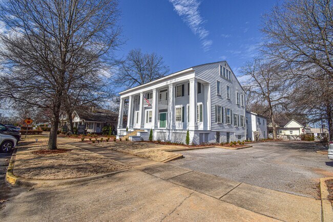

This Property Is For Sale
NEARBY LISTINGS FOR SALE OR LEASE
Property Detail
2606 8Th St
Tuscaloosa, AL
Orig City Of Tusc
31-05-22-3-008-010.000
LOT PT. 251 IN ORIG. CITY, SUR. SUBD DESC. AS: COM NE COR LOT 251 TH SW 40' TO BEG TH SW 75' TH NW 132 (D) 127 (S) TH NE 75' TH SE 132 (D) 127 (S) TOB POB
Officebuilding
Tuscaloosa
X
Alabama
01125C0504F
251
2025
0.22 AC
2024
Tuscaloosa
011600
Birmingham
5,026 SF
DEMOGRAPHICS near 2606 8Th St
1 Mile
3 Mile
5 Mile
2024 Total Population
11,991
80,737
132,397
2029 Population
14,062
90,703
149,320
Pop Growth 2024-2029
+ 17.27%
+ 12.34%
+ 12.78%
Average Age
33
33
34
2024 Total Households
5,326
28,941
50,849
HH Growth 2024-2029
+ 17.44%
+ 15.36%
+ 14.34%
Median Household Inc
$23,646
$33,861
$43,023
Avg Household Size
1.90
2.10
2.10
2024 Avg HH Vehicles
1.00
2.00
2.00
Median Home Value
$206,780
$201,366
$196,162
Median Year Built
1982
1985
1989
Nearby Places
Map Layers
Map Styles
 Street
 Aerial
- Restaurants
- Banks
- Shops
- Fitness
- Groceries
PUBLIC TRANSPORTATION
COMMUTER RAIL
Tuscaloosa Amtrak Station (Crescent - Amtrak)
DRIVE
WALK
Distance
Tuscaloosa Amtrak Station (Crescent - Amtrak)
2 min
1.2 mi
Freight Ports
Port of Mobile
DRIVE
WALK
Distance
Port of Mobile
239 min
200.0 mi
Nearby Properties
Address
Land Use
TOTAL SIZE
Lot Size
Zoning
Address
Land Use
TOTAL SIZE
Lot Size
Zoning
318,383 SF
44 SF
BN
Address
Land Use
TOTAL SIZE
Lot Size
Zoning
22,791 SF
13 AC
Address
Land Use
TOTAL SIZE
Lot Size
Zoning
148,656 SF
2.79 AC
BC
Address
Land Use
TOTAL SIZE
Lot Size
Zoning
22,925 SF
13.45 AC
R4
Address
Land Use
TOTAL SIZE
Lot Size
Zoning
252,793 SF
2.73 AC
BN
Address
Land Use
TOTAL SIZE
Lot Size
Zoning
279,917 SF
4.01 AC
MX3
Address
Land Use
TOTAL SIZE
Lot Size
Zoning
24,165 SF
28 AC
BN
Address
Land Use
TOTAL SIZE
Lot Size
Zoning
40,160 SF
10.79 AC
RMF1
Address
Land Use
TOTAL SIZE
Lot Size
Zoning
25,920 SF
16 AC
RMF1
Address
Land Use
TOTAL SIZE
Lot Size
Zoning
6,579 SF
15.07 AC
RMF1
Address
Land Use
TOTAL SIZE
Lot Size
Zoning
231,339 SF
4.20 AC
MX5
Address
Land Use
TOTAL SIZE
Lot Size
Zoning
160,989 SF
1.53 AC
RMF2
Address
Land Use
TOTAL SIZE
Lot Size
Zoning
1.33 AC
BC
Address
Land Use
TOTAL SIZE
Lot Size
Zoning
176,360 SF
1.13 AC
RMF2
Address
Land Use
TOTAL SIZE
Lot Size
Zoning
15,888 SF
112 AC
I
Address
Land Use
TOTAL SIZE
Lot Size
Zoning
200,388 SF
1.22 AC
Address
Land Use
TOTAL SIZE
Lot Size
Zoning
24,360 SF
142 AC
Address
Land Use
TOTAL SIZE
Lot Size
Zoning
110,337 SF
0.91 AC
RMF2
Address
Land Use
TOTAL SIZE
Lot Size
Zoning
105,728 SF
4.75 AC
BGO
Address
Land Use
TOTAL SIZE
Lot Size
Zoning
121,384 SF
21 AC
O-I
Address
Land Use
TOTAL SIZE
Lot Size
Zoning
196,378 SF
1.46 AC
MX5
Address
Land Use
TOTAL SIZE
Lot Size
Zoning
173,452 SF
2.30 AC
ML
Address
Land Use
TOTAL SIZE
Lot Size
Zoning
144,660 SF
1 AC
RMF2
Address
Land Use
TOTAL SIZE
Lot Size
Zoning
110,000 SF
5.80 AC
RD
Address
Land Use
TOTAL SIZE
Lot Size
Zoning
26,576 SF
2.53 AC
RD
Address
Land Use
TOTAL SIZE
Lot Size
Zoning
15.30 AC
Address
Land Use
TOTAL SIZE
Lot Size
Zoning
115,911 SF
4.48 AC
I
Address
Land Use
TOTAL SIZE
Lot Size
Zoning
12 AC
R1
Address
Land Use
TOTAL SIZE
Lot Size
Zoning
45,716 SF
8.80 AC
R4
Address
Land Use
TOTAL SIZE
Lot Size
Zoning
12,048 SF
21 AC
RM2
The World's #1 Commercial Real Estate Marketplace
Connect with us
© 2026 CoStar Group
The information above has been obtained from sources believed reliable. While we do not doubt its accuracy we have not verified it and make no guarantee, warranty or representation about it. It is your responsibility to independently confirm its accuracy and completeness. Any projections, opinions, assumptions, or estimates used are for example only and do not represent the current or future performance of the property. The value of this transaction to you depends on tax and other factors which should be evaluated by your tax, financial, and legal advisors. You and your advisors should conduct a careful, independent investigation of the property to determine to your satisfaction the suitability of the property for your needs.