Property Record
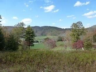
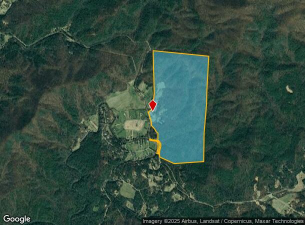
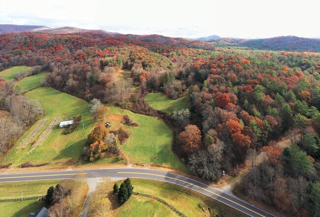
26065 Morganton Hwy, Suches, GA 30572
NEARBY LISTINGS FOR SALE OR LEASE
-
-
View all Suches listings for sale on LoopNet.com
Property Detail
26065 Morganton Hwy
0004-004
Zone 2 Rural
Agriculturalland
7-1 LL240,241,264,265 DB1505-99* 332.11 ACS
A
Fannin
13111C0219E
Georgia
2024
240
2025
332.11 AC
050500
Georgia Northeast
1,792 SF
Other Market Areas
DEMOGRAPHICS near 26065 Morganton Hwy
1 Mile
3 Mile
5 Mile
2024 Total Population
144
630
1,534
2029 Population
159
696
1,725
Pop Growth 2024-2029
+ 10.42%
+ 10.48%
+ 12.45%
Average Age
55
54
53
2024 Total Households
70
304
723
HH Growth 2024-2029
+ 11.43%
+ 10.53%
+ 12.31%
Median Household Inc
$78,333
$77,358
$66,596
Avg Household Size
2.00
2.10
2.10
2024 Avg HH Vehicles
2.00
2.00
2.00
Median Home Value
$321,428
$336,842
$312,903
Median Year Built
2002
2002
2000
Nearby Places
Map Layers
Map Styles
 Street
 Aerial
- Restaurants
- Banks
- Shops
- Fitness
- Groceries
SALE & LEASE HISTORY
LISTING DATE
SALE/LEASE

Sep 24, 2016
For Sale
Oct 29, 2021
For Sale
Nearby Properties
Address
Land Use
TOTAL SIZE
Lot Size
Zoning
Address
Land Use
TOTAL SIZE
Lot Size
Zoning
1,344 SF
21.65 AC
RESIDENTIA
Address
Land Use
TOTAL SIZE
Lot Size
Zoning
1,064 SF
40.75 AC
RURAL
Address
Land Use
TOTAL SIZE
Lot Size
Zoning
690 AC
RESIDENTIA
Address
Land Use
TOTAL SIZE
Lot Size
Zoning
1,624 SF
10 AC
RURAL
Address
Land Use
TOTAL SIZE
Lot Size
Zoning
79.40 AC
RURAL
Address
Land Use
TOTAL SIZE
Lot Size
Zoning
11.77 AC
RURAL
Address
Land Use
TOTAL SIZE
Lot Size
Zoning
89.14 AC
RURAL
Address
Land Use
TOTAL SIZE
Lot Size
Zoning
5.90 AC
RURAL
Address
Land Use
TOTAL SIZE
Lot Size
Zoning
49.80 AC
RURAL
Address
Land Use
TOTAL SIZE
Lot Size
Zoning
14.31 AC
RURAL
Address
Land Use
TOTAL SIZE
Lot Size
Zoning
19.02 AC
RURAL
Address
Land Use
TOTAL SIZE
Lot Size
Zoning
50.64 AC
RURAL
Address
Land Use
TOTAL SIZE
Lot Size
Zoning
4.80 AC
RESIDENTIA
Address
Land Use
TOTAL SIZE
Lot Size
Zoning
1,343 SF
19.33 AC
RURAL
Address
Land Use
TOTAL SIZE
Lot Size
Zoning
52.60 AC
RURAL
Address
Land Use
TOTAL SIZE
Lot Size
Zoning
30.50 AC
RESIDENTIA
Address
Land Use
TOTAL SIZE
Lot Size
Zoning
53.80 AC
RURAL
Address
Land Use
TOTAL SIZE
Lot Size
Zoning
27.27 AC
RURAL
Address
Land Use
TOTAL SIZE
Lot Size
Zoning
5.10 AC
RESIDENTIA
Address
Land Use
TOTAL SIZE
Lot Size
Zoning
13.17 AC
RESIDENTIA
Address
Land Use
TOTAL SIZE
Lot Size
Zoning
30.42 AC
RURAL
Address
Land Use
TOTAL SIZE
Lot Size
Zoning
4.93 AC
RESIDENTIA
Address
Land Use
TOTAL SIZE
Lot Size
Zoning
40.79 AC
RURAL
Address
Land Use
TOTAL SIZE
Lot Size
Zoning
15.76 AC
RURAL
Address
Land Use
TOTAL SIZE
Lot Size
Zoning
4.24 AC
RESIDENTIA
Address
Land Use
TOTAL SIZE
Lot Size
Zoning
5.02 AC
RESIDENTIA
Address
Land Use
TOTAL SIZE
Lot Size
Zoning
34.98 AC
RURAL
Address
Land Use
TOTAL SIZE
Lot Size
Zoning
14.20 AC
RURAL
Address
Land Use
TOTAL SIZE
Lot Size
Zoning
22.45 AC
RURAL
The World's #1 Commercial Real Estate Marketplace
Connect with us
© 2026 CoStar Group
The information above has been obtained from sources believed reliable. While we do not doubt its accuracy we have not verified it and make no guarantee, warranty or representation about it. It is your responsibility to independently confirm its accuracy and completeness. Any projections, opinions, assumptions, or estimates used are for example only and do not represent the current or future performance of the property. The value of this transaction to you depends on tax and other factors which should be evaluated by your tax, financial, and legal advisors. You and your advisors should conduct a careful, independent investigation of the property to determine to your satisfaction the suitability of the property for your needs.