Property Record
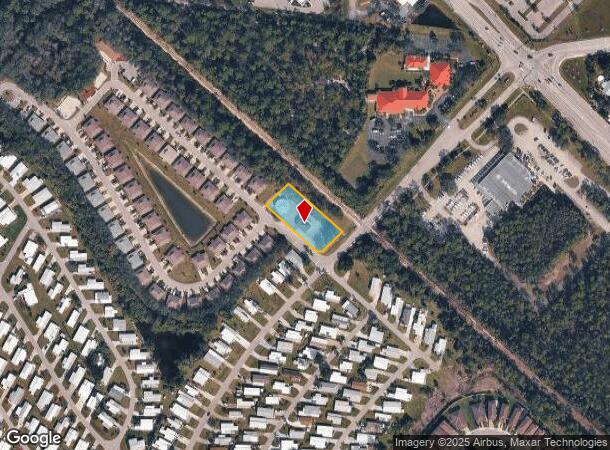
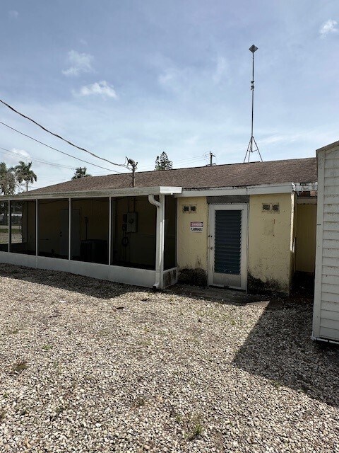
26095 Imperial Harbor Blvd, Bonita Springs, FL 34135

NEARBY LISTINGS FOR SALE OR LEASE
Property Detail
26095 Imperial Harbor Blvd
Cape Coral-Fort Myers, FL
Bonita
27-47-25-B2-00106.0010
IMPERIAL HARBOR UNIT 1 BLK.6 PB 11 PG 57 LOT 1
Orphanage
Lee
AE
Florida
12071C0656G
1
2024
0.67 AC
2025
Bonita Springs
050402
Southwest Florida
1,631 SF
DEMOGRAPHICS near 26095 Imperial Harbor Blvd
1 Mile
3 Mile
5 Mile
2024 Total Population
9,435
53,705
94,271
2029 Population
11,263
64,474
112,966
Pop Growth 2024-2029
+ 19.37%
+ 20.05%
+ 19.83%
Average Age
53
54
57
2024 Total Households
4,160
24,691
45,072
HH Growth 2024-2029
+ 19.33%
+ 19.90%
+ 19.53%
Median Household Inc
$59,776
$79,866
$85,151
Avg Household Size
2.20
2.10
2.00
2024 Avg HH Vehicles
2.00
2.00
2.00
Median Home Value
$272,256
$390,283
$418,351
Median Year Built
1996
1997
1997
Nearby Places
- Restaurants
- Banks
- Shops
- Fitness
- Groceries
PUBLIC TRANSPORTATION
AIRPORT
Southwest Florida International
DRIVE
WALK
Distance
Southwest Florida International
31 min
19.2 mi
Freight Ports
Port Manatee
DRIVE
WALK
Distance
Port Manatee
139 min
119.0 mi
SALE & LEASE HISTORY
LISTING DATE
SALE/LEASE

Jul 21, 2024
For Sale
Nearby Properties
Address
Land Use
TOTAL SIZE
Lot Size
Zoning
Address
Land Use
TOTAL SIZE
Lot Size
Zoning
177,930 SF
20.74 AC
MPD
Address
Land Use
TOTAL SIZE
Lot Size
Zoning
406,601 SF
19.88 AC
RPD
Address
Land Use
TOTAL SIZE
Lot Size
Zoning
311,416 SF
17.06 AC
Address
Land Use
TOTAL SIZE
Lot Size
Zoning
331,056 SF
8 AC
CPD
Address
Land Use
TOTAL SIZE
Lot Size
Zoning
221,244 SF
65.55 AC
MPD
Address
Land Use
TOTAL SIZE
Lot Size
Zoning
293,332 SF
7.03 AC
CPD
Address
Land Use
TOTAL SIZE
Lot Size
Zoning
366,884 SF
30.65 AC
RM-2
Address
Land Use
TOTAL SIZE
Lot Size
Zoning
286,416 SF
28.78 AC
CG
Address
Land Use
TOTAL SIZE
Lot Size
Zoning
214,836 SF
24.50 AC
CPD
Address
Land Use
TOTAL SIZE
Lot Size
Zoning
464,234 SF
22.53 AC
CPD
Address
Land Use
TOTAL SIZE
Lot Size
Zoning
182,802 SF
18.08 AC
CC
Address
Land Use
TOTAL SIZE
Lot Size
Zoning
48,538 SF
4.46 AC
CC
Address
Land Use
TOTAL SIZE
Lot Size
Zoning
97,916 SF
19.72 AC
CF-2
Address
Land Use
TOTAL SIZE
Lot Size
Zoning
181,680 SF
9.89 AC
MPD
Address
Land Use
TOTAL SIZE
Lot Size
Zoning
8.87 AC
CT
Address
Land Use
TOTAL SIZE
Lot Size
Zoning
144,993 SF
8.73 AC
PUD
Address
Land Use
TOTAL SIZE
Lot Size
Zoning
Address
Land Use
TOTAL SIZE
Lot Size
Zoning
103,495 SF
13.29 AC
CPD
Address
Land Use
TOTAL SIZE
Lot Size
Zoning
1.50 AC
RPD
Address
Land Use
TOTAL SIZE
Lot Size
Zoning
111,478 SF
15.76 AC
AG-2
Address
Land Use
TOTAL SIZE
Lot Size
Zoning
117,766 SF
4.48 AC
RPD
Address
Land Use
TOTAL SIZE
Lot Size
Zoning
72,099 SF
11.54 AC
AG-2
Address
Land Use
TOTAL SIZE
Lot Size
Zoning
97,016 SF
5.03 AC
RPD
Address
Land Use
TOTAL SIZE
Lot Size
Zoning
126,947 SF
15.86 AC
CF-2
Address
Land Use
TOTAL SIZE
Lot Size
Zoning
87,430 SF
7.30 AC
IPD
Address
Land Use
TOTAL SIZE
Lot Size
Zoning
137,260 SF
5.37 AC
CPD
Address
Land Use
TOTAL SIZE
Lot Size
Zoning
64,806 SF
9.82 AC
CFPD
Address
Land Use
TOTAL SIZE
Lot Size
Zoning
125,641 SF
11.07 AC
CPD
Address
Land Use
TOTAL SIZE
Lot Size
Zoning
71,349 SF
13.16 AC
CC
Address
Land Use
TOTAL SIZE
Lot Size
Zoning
112,563 SF
13.05 AC
CC-1
The World's #1 Commercial Real Estate Marketplace
Connect with us
© 2025 CoStar Group
The information above has been obtained from sources believed reliable. While we do not doubt its accuracy we have not verified it and make no guarantee, warranty or representation about it. It is your responsibility to independently confirm its accuracy and completeness. Any projections, opinions, assumptions, or estimates used are for example only and do not represent the current or future performance of the property. The value of this transaction to you depends on tax and other factors which should be evaluated by your tax, financial, and legal advisors. You and your advisors should conduct a careful, independent investigation of the property to determine to your satisfaction the suitability of the property for your needs.