Property Record
26099 Fort Cir, Valley, NE 68064
Property Detail
26099 Fort Cir
Omaha, NE-IA
LANDS SEC-TWN-RGE 05-15-10 -EX PT FOR NEW HWY & PLATTE VALLEY COM PARK- IRREG E 350.02 FT OF PT N & E OF HWY 275 & RR RWY W 1/2 NE 1/4 10.025 AC PARCEL B DESC IN 2024030485
0106-2500-20
Douglas
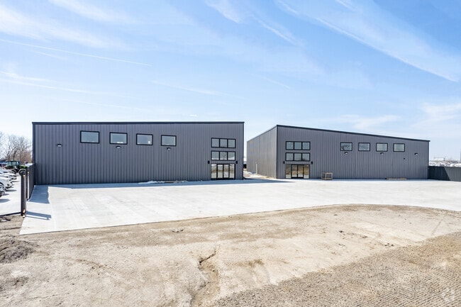
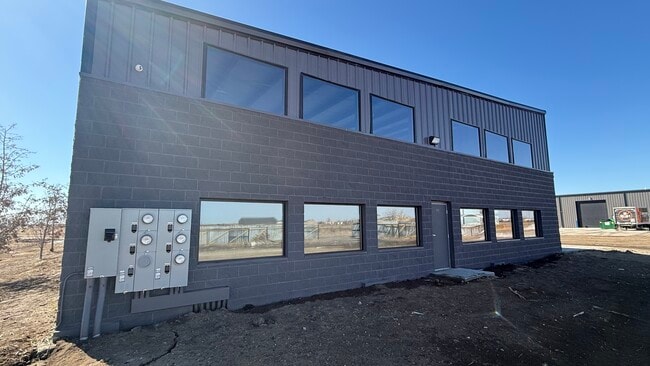
Warehouse
Nebraska
AO River or stream flood hazard areas, and areas with a 1% or greater chance of shallow flooding each year. These areas have a 26% chance of flooding over the life of a 30-year mortgage.
10.24 AC
2024
Northwest Omaha
2025
Omaha/Council Bluffs
39,384 SF
NEARBY LISTINGS FOR SALE OR LEASE
DEMOGRAPHICS near 26099 Fort Cir
1 mile
3 mile
5 mile
2025 Total Population
110
5,227
18,139
2030 Population
114
5,580
19,288
Pop Growth 2025-2030
+ 3.64%
+ 6.75%
+ 6.33%
Average Age
42
44
41
2025 Total Households
44
2,207
6,951
HH Growth 2025-2030
+ 4.55%
+ 7.20%
+ 6.75%
Median Household Inc
$112,500
$99,277
$114,684
Avg Household Size
2.50
2.40
2.60
2025 Avg HH Vehicles
2.00
2.00
2.00
Median Home Value
$557,692
$541,480
$425,864
Median Year Built
1962
1978
1998
Nearby Places
Map Layers
Map Styles
 Street
 Aerial
Layers
 Traffic
 Biking
Places
Listings with unknown addresses are not visible on the map
- Restaurants
- Banks
- Shops
- Fitness
- Groceries
PUBLIC TRANSPORTATION
AIRPORT
Eppley Airfield
Drive
Walk
Distance
Eppley Airfield
44 min
27.1 mi
Freight Ports
Tulsa Port Of Catoosa
Drive
Walk
Distance
Tulsa Port Of Catoosa
491 min
441.5 mi
Nearby Properties
Address
Land Use
TOTAL SIZE
Lot Size
Zoning
Address
Land Use
TOTAL SIZE
Lot Size
Zoning
441,099 SF
114.30 AC
Address
Land Use
TOTAL SIZE
Lot Size
Zoning
731,561 SF
256.02 AC
Address
Land Use
TOTAL SIZE
Lot Size
Zoning
272,916 SF
27.09 AC
Address
Land Use
TOTAL SIZE
Lot Size
Zoning
154,061 SF
4.85 AC
Address
Land Use
TOTAL SIZE
Lot Size
Zoning
242,139 SF
64.40 AC
Address
Land Use
TOTAL SIZE
Lot Size
Zoning
214,360 SF
24.93 AC
Address
Land Use
TOTAL SIZE
Lot Size
Zoning
121,076 SF
9.07 AC
Address
Land Use
TOTAL SIZE
Lot Size
Zoning
53,864 SF
12.56 AC
Address
Land Use
TOTAL SIZE
Lot Size
Zoning
73,505 SF
4.09 AC
Address
Land Use
TOTAL SIZE
Lot Size
Zoning
55,185 SF
3.81 AC
Address
Land Use
TOTAL SIZE
Lot Size
Zoning
32,665 SF
9.63 AC
Address
Land Use
TOTAL SIZE
Lot Size
Zoning
56,640 SF
3.72 AC
Address
Land Use
TOTAL SIZE
Lot Size
Zoning
9,838 SF
10.20 AC
Address
Land Use
TOTAL SIZE
Lot Size
Zoning
30,000 SF
1.68 AC
Address
Land Use
TOTAL SIZE
Lot Size
Zoning
17,760 SF
Address
Land Use
TOTAL SIZE
Lot Size
Zoning
62,970 SF
4.89 AC
Address
Land Use
TOTAL SIZE
Lot Size
Zoning
25,929 SF
1.65 AC
Address
Land Use
TOTAL SIZE
Lot Size
Zoning
25,929 SF
1.57 AC
Address
Land Use
TOTAL SIZE
Lot Size
Zoning
18,351 SF
1.40 AC
Address
Land Use
TOTAL SIZE
Lot Size
Zoning
18,000 SF
4 AC
Address
Land Use
TOTAL SIZE
Lot Size
Zoning
79,600 SF
1.67 AC
Address
Land Use
TOTAL SIZE
Lot Size
Zoning
32,772 SF
3.15 AC
WATERLOO
Address
Land Use
TOTAL SIZE
Lot Size
Zoning
28,000 SF
17.92 AC
Address
Land Use
TOTAL SIZE
Lot Size
Zoning
22,500 SF
4 AC
Address
Land Use
TOTAL SIZE
Lot Size
Zoning
38,000 SF
10 AC
AG
Address
Land Use
TOTAL SIZE
Lot Size
Zoning
16,000 SF
0.57 AC
Address
Land Use
TOTAL SIZE
Lot Size
Zoning
9,008 SF
67.36 AC
The World's #1 Commercial Real Estate Marketplace
Connect with us
© 2026 CoStar Group
The information above has been obtained from sources believed reliable. While we do not doubt its accuracy we have not verified it and make no guarantee, warranty or representation about it. It is your responsibility to independently confirm its accuracy and completeness. Any projections, opinions, assumptions, or estimates used are for example only and do not represent the current or future performance of the property. The value of this transaction to you depends on tax and other factors which should be evaluated by your tax, financial, and legal advisors. You and your advisors should conduct a careful, independent investigation of the property to determine to your satisfaction the suitability of the property for your needs.