Property Record
260Th St, Westbrook, MN 56183

Property Detail
260Th St
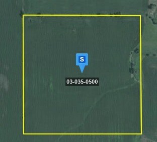
03-035-0500
NW1/4 SE1/4 40
Agriculturalland
COTTONWOOD
B and X Area of moderate flood hazard, usually the area between the limits of the 100-year and 500-year floods.
Minnesota
2025
40 AC
2025
Minnesota South Area
270200
Other Market Areas
NEARBY LISTINGS FOR SALE OR LEASE
-
-
View all Westbrook listings for sale on LoopNet.com
DEMOGRAPHICS near 260Th St
1 mile
3 mile
5 mile
2025 Total Population
13
100
294
2030 Population
13
97
284
Pop Growth 2025-2030
0.00%
(3.00%)
(3.40%)
Average Age
45
47
46
2025 Total Households
6
46
132
HH Growth 2025-2030
0.00%
(4.35%)
(3.03%)
Median Household Inc
$19,999
$53,333
$62,500
Avg Household Size
2.20
2.10
2.20
2025 Avg HH Vehicles
2.00
2.00
2.00
Median Home Value
$99,999
$150,000
$151,785
Median Year Built
1948
1948
1949
Nearby Places
Map Layers
Map Styles
 Street
 Aerial
Transit
 Traffic
 Biking
Places
Listings with unknown addresses are not visible on the map
- Restaurants
- Banks
- Shops
- Fitness
- Groceries
Nearby Properties
Address
Land Use
TOTAL SIZE
Lot Size
Zoning
Address
Land Use
TOTAL SIZE
Lot Size
Zoning
1,196 SF
493.81 AC
Address
Land Use
TOTAL SIZE
Lot Size
Zoning
1,108 SF
409 AC
Address
Land Use
TOTAL SIZE
Lot Size
Zoning
1,320 SF
160 AC
Address
Land Use
TOTAL SIZE
Lot Size
Zoning
Address
Land Use
TOTAL SIZE
Lot Size
Zoning
1,800 SF
171.33 AC
Address
Land Use
TOTAL SIZE
Lot Size
Zoning
1,947 SF
155.51 AC
Address
Land Use
TOTAL SIZE
Lot Size
Zoning
600 SF
160 AC
Address
Land Use
TOTAL SIZE
Lot Size
Zoning
Address
Land Use
TOTAL SIZE
Lot Size
Zoning
1,340 SF
159.99 AC
Address
Land Use
TOTAL SIZE
Lot Size
Zoning
113.35 AC
Address
Land Use
TOTAL SIZE
Lot Size
Zoning
2,331 SF
81 AC
Address
Land Use
TOTAL SIZE
Lot Size
Zoning
144.26 AC
Address
Land Use
TOTAL SIZE
Lot Size
Zoning
1,428 SF
80 AC
Address
Land Use
TOTAL SIZE
Lot Size
Zoning
224 SF
160 AC
Address
Land Use
TOTAL SIZE
Lot Size
Zoning
1,512 SF
80 AC
Address
Land Use
TOTAL SIZE
Lot Size
Zoning
352 SF
152.28 AC
Address
Land Use
TOTAL SIZE
Lot Size
Zoning
944 SF
80 AC
Address
Land Use
TOTAL SIZE
Lot Size
Zoning
416 SF
80 AC
Address
Land Use
TOTAL SIZE
Lot Size
Zoning
16,728 SF
80 AC
Address
Land Use
TOTAL SIZE
Lot Size
Zoning
1,600 SF
136.31 AC
Address
Land Use
TOTAL SIZE
Lot Size
Zoning
Address
Land Use
TOTAL SIZE
Lot Size
Zoning
Address
Land Use
TOTAL SIZE
Lot Size
Zoning
1,476 SF
152.01 AC
Address
Land Use
TOTAL SIZE
Lot Size
Zoning
Address
Land Use
TOTAL SIZE
Lot Size
Zoning
1,096 SF
80 AC
Address
Land Use
TOTAL SIZE
Lot Size
Zoning
71.23 AC
Address
Land Use
TOTAL SIZE
Lot Size
Zoning
1,918 SF
64.61 AC
Address
Land Use
TOTAL SIZE
Lot Size
Zoning
Address
Land Use
TOTAL SIZE
Lot Size
Zoning
1,142 SF
80 AC
Address
Land Use
TOTAL SIZE
Lot Size
Zoning
The World's #1 Commercial Real Estate Marketplace
Connect with us
© 2026 CoStar Group
The information above has been obtained from sources believed reliable. While we do not doubt its accuracy we have not verified it and make no guarantee, warranty or representation about it. It is your responsibility to independently confirm its accuracy and completeness. Any projections, opinions, assumptions, or estimates used are for example only and do not represent the current or future performance of the property. The value of this transaction to you depends on tax and other factors which should be evaluated by your tax, financial, and legal advisors. You and your advisors should conduct a careful, independent investigation of the property to determine to your satisfaction the suitability of the property for your needs.