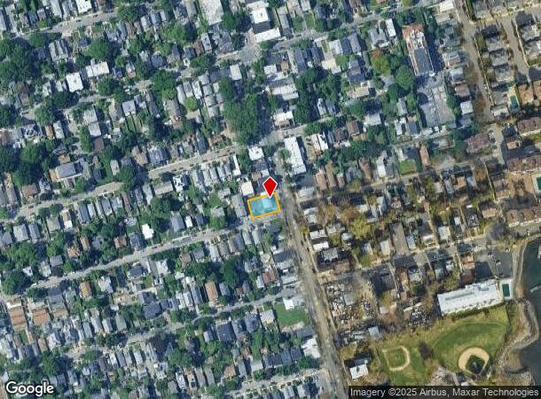
Property Record
261 City Island Ave, Bronx, NY 10464
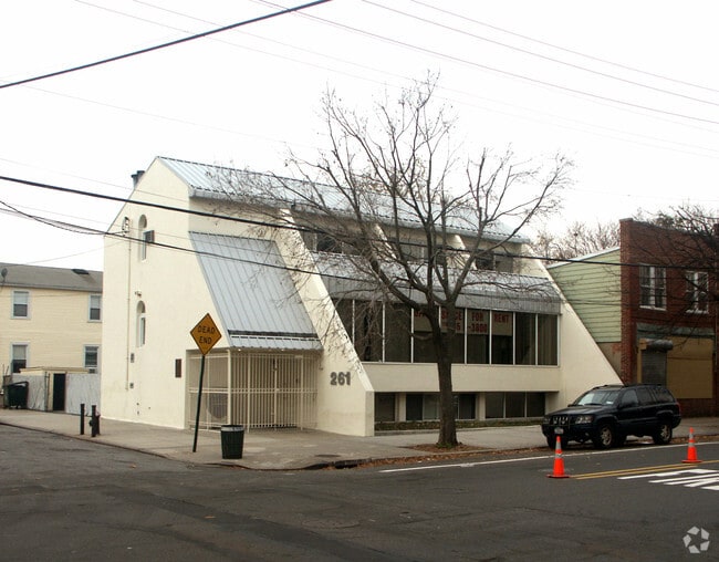

This Property Is For Sale
Current Lease Availabilities
NEARBY LISTINGS FOR SALE OR LEASE
Property Detail
261 City Island Ave
05629-0236
Bronx
Officebuilding
New York
X
236
3604970106F
0.13 AC
2024
Bronx
2025
Westchester/So Connecticut
051601
New York-Jersey City-White Plains, NY-NJ
4,720 SF
DEMOGRAPHICS near 261 City Island Ave
1 Mile
3 Mile
5 Mile
2024 Total Population
3,929
85,677
649,926
2029 Population
3,592
76,820
596,240
Pop Growth 2024-2029
(8.58%)
(10.34%)
(8.26%)
Average Age
48
43
40
2024 Total Households
1,814
33,188
234,814
HH Growth 2024-2029
(9.26%)
(11.15%)
(8.75%)
Median Household Inc
$121,052
$68,072
$62,528
Avg Household Size
2.10
2.40
2.60
2024 Avg HH Vehicles
2.00
1.00
1.00
Median Home Value
$693,164
$544,675
$635,969
Median Year Built
1948
1960
1955
Nearby Places
- Restaurants
- Banks
- Shops
- Fitness
- Groceries
PUBLIC TRANSPORTATION
COMMUTER RAIL
Pelham Station (New Haven Line - Metro-North Commuter Railroad Company (Metro-North))
DRIVE
WALK
Distance
Pelham Station (New Haven Line - Metro-North Commuter Railroad Company (Metro-North))
13 min
5.8 mi
Williams Bridge Station (Harlem Line - Metro-North Commuter Railroad Company (Metro-North))
DRIVE
WALK
Distance
Williams Bridge Station (Harlem Line - Metro-North Commuter Railroad Company (Metro-North))
15 min
6.4 mi
AIRPORT
LaGuardia
DRIVE
WALK
Distance
LaGuardia
25 min
13.1 mi
John F Kennedy International
DRIVE
WALK
Distance
John F Kennedy International
32 min
20.6 mi
Westchester County
DRIVE
WALK
Distance
Westchester County
34 min
21.6 mi
Freight Ports
NY - Red Hook Container Terminal
DRIVE
WALK
Distance
NY - Red Hook Container Terminal
40 min
23.6 mi
Nearby Properties
Address
Land Use
TOTAL SIZE
Lot Size
Zoning
Address
Land Use
TOTAL SIZE
Lot Size
Zoning
550,000 SF
8.75 AC
M1-1
Address
Land Use
TOTAL SIZE
Lot Size
Zoning
119,980 SF
1,704.55 AC
PARK
Address
Land Use
TOTAL SIZE
Lot Size
Zoning
5,000 SF
363.58 AC
PARK
Address
Land Use
TOTAL SIZE
Lot Size
Zoning
485,484 SF
39.63 AC
R5
Address
Land Use
TOTAL SIZE
Lot Size
Zoning
703,265 SF
83.45 AC
R4
Address
Land Use
TOTAL SIZE
Lot Size
Zoning
537,208 SF
4.73 AC
C4-3
Address
Land Use
TOTAL SIZE
Lot Size
Zoning
545,388 SF
29.07 AC
C4-3
Address
Land Use
TOTAL SIZE
Lot Size
Zoning
361,354 SF
C4-2
Address
Land Use
TOTAL SIZE
Lot Size
Zoning
510 SF
68.73 AC
PARK
Address
Land Use
TOTAL SIZE
Lot Size
Zoning
191,800 SF
13.39 AC
C4-3
Address
Land Use
TOTAL SIZE
Lot Size
Zoning
450,879 SF
9.10 AC
M1-1
Address
Land Use
TOTAL SIZE
Lot Size
Zoning
450,000 SF
5.59 AC
R6
Address
Land Use
TOTAL SIZE
Lot Size
Zoning
726,051 SF
33.66 AC
R5
Address
Land Use
TOTAL SIZE
Lot Size
Zoning
274,840 SF
2.80 AC
M1-1
Address
Land Use
TOTAL SIZE
Lot Size
Zoning
12,150 SF
482.09 AC
PARK
Address
Land Use
TOTAL SIZE
Lot Size
Zoning
262,716 SF
2.80 AC
M1-1
Address
Land Use
TOTAL SIZE
Lot Size
Zoning
1,172,800 SF
19.66 AC
R4
Address
Land Use
TOTAL SIZE
Lot Size
Zoning
10,181 SF
30.72 AC
M1-1
Address
Land Use
TOTAL SIZE
Lot Size
Zoning
138,305 SF
3.18 AC
R6
Address
Land Use
TOTAL SIZE
Lot Size
Zoning
158,282 SF
2.38 AC
R4A
Address
Land Use
TOTAL SIZE
Lot Size
Zoning
150,613 SF
3.90 AC
R3-2
Address
Land Use
TOTAL SIZE
Lot Size
Zoning
188,760 SF
1.95 AC
R6
Address
Land Use
TOTAL SIZE
Lot Size
Zoning
366,375 SF
12.03 AC
M1-1
Address
Land Use
TOTAL SIZE
Lot Size
Zoning
170,513 SF
3.86 AC
C4-3
Address
Land Use
TOTAL SIZE
Lot Size
Zoning
50,767 SF
3.74 AC
M1-1
Address
Land Use
TOTAL SIZE
Lot Size
Zoning
146,100 SF
2.99 AC
R4
Address
Land Use
TOTAL SIZE
Lot Size
Zoning
159,856 SF
1.38 AC
C4-3
Address
Land Use
TOTAL SIZE
Lot Size
Zoning
132,200 SF
10.75 AC
C4-1
Address
Land Use
TOTAL SIZE
Lot Size
Zoning
321,300 SF
11.55 AC
R4
Address
Land Use
TOTAL SIZE
Lot Size
Zoning
419,742 SF
2.43 AC
C4-3
The World's #1 Commercial Real Estate Marketplace
Connect with us
© 2025 CoStar Group
The information above has been obtained from sources believed reliable. While we do not doubt its accuracy we have not verified it and make no guarantee, warranty or representation about it. It is your responsibility to independently confirm its accuracy and completeness. Any projections, opinions, assumptions, or estimates used are for example only and do not represent the current or future performance of the property. The value of this transaction to you depends on tax and other factors which should be evaluated by your tax, financial, and legal advisors. You and your advisors should conduct a careful, independent investigation of the property to determine to your satisfaction the suitability of the property for your needs.