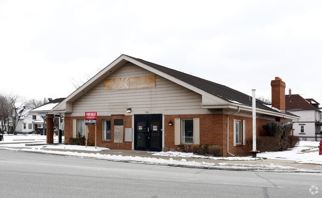
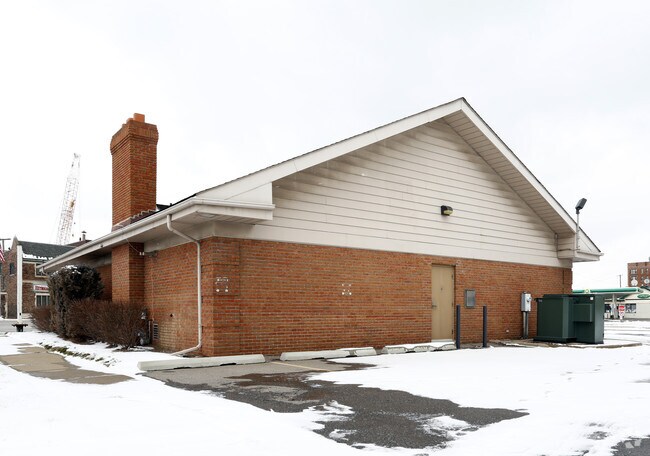
Property Record
261 Burke St, River Rouge, MI 48218

NEARBY LISTINGS FOR SALE OR LEASE
-
-
-
No Photo
-
-
-
-
-
-
View all River Rouge listings for sale on LoopNet.com
Property Detail
261 Burke St
Detroit-Warren-Dearborn, MI
John Neimans
50-005-03-0006-000
25E6 TO 10 LOTS 6 TO 10 INCL JOHN NEIMANS SUB PC 25 L26 P68 WCR
Medicalbuilding
Wayne
X
Michigan
26163C0269F
6-10
2025
0.36 AC
2025
Downriver North
579200
Detroit
2,565 SF
DEMOGRAPHICS near 261 Burke St
1 mile
3 mile
5 mile
2024 Total Population
11,395
70,764
205,345
2029 Population
11,335
68,768
198,266
Pop Growth 2024-2029
(0.53%)
(2.82%)
(3.45%)
Average Age
38
36
37
2024 Total Households
4,324
25,421
74,664
HH Growth 2024-2029
(0.67%)
(2.81%)
(3.51%)
Median Household Inc
$31,291
$39,611
$49,041
Avg Household Size
2.50
2.70
2.70
2024 Avg HH Vehicles
1.00
1.00
2.00
Median Home Value
$60,249
$78,261
$127,148
Median Year Built
1948
1950
1951
Nearby Places
Map Layers
Map Styles
 Street
 Aerial
Transit
 Traffic
 Biking
Places
Listings with unknown addresses are not visible on the map
- Restaurants
- Banks
- Shops
- Fitness
- Groceries
PUBLIC TRANSPORTATION
COMMUTER RAIL
Drive
Walk
Distance
17 min
7.3 mi
AIRPORT
Detroit Metro Wayne County
Drive
Walk
Distance
Detroit Metro Wayne County
30 min
16.9 mi
Windsor International
Drive
Walk
Distance
Windsor International
35 min
17.5 mi
Freight Ports
Drive
Walk
Distance
69 min
54.4 mi
Nearby Properties
Address
Land Use
TOTAL SIZE
Lot Size
Zoning
Address
Land Use
TOTAL SIZE
Lot Size
Zoning
590,116 SF
388.80 AC
ID
Address
Land Use
TOTAL SIZE
Lot Size
Zoning
7,320 SF
226.49 AC
Address
Land Use
TOTAL SIZE
Lot Size
Zoning
309,661 SF
8.81 AC
M4
Address
Land Use
TOTAL SIZE
Lot Size
Zoning
196,801 SF
38.32 AC
M5
Address
Land Use
TOTAL SIZE
Lot Size
Zoning
193,155 SF
8.68 AC
R1 1 FA
Address
Land Use
TOTAL SIZE
Lot Size
Zoning
145,572 SF
58.41 AC
M4
Address
Land Use
TOTAL SIZE
Lot Size
Zoning
314,003 SF
26.32 AC
B6
Address
Land Use
TOTAL SIZE
Lot Size
Zoning
76,350 SF
0.69 AC
Address
Land Use
TOTAL SIZE
Lot Size
Zoning
79.03 AC
M2 HEAV
Address
Land Use
TOTAL SIZE
Lot Size
Zoning
52,964 SF
10.89 AC
Address
Land Use
TOTAL SIZE
Lot Size
Zoning
351,906 SF
42.21 AC
M4
Address
Land Use
TOTAL SIZE
Lot Size
Zoning
183,311 SF
15.99 AC
M4
Address
Land Use
TOTAL SIZE
Lot Size
Zoning
897,317 SF
34.53 AC
ID
Address
Land Use
TOTAL SIZE
Lot Size
Zoning
383,352 SF
8.23 AC
M4
Address
Land Use
TOTAL SIZE
Lot Size
Zoning
90,005 SF
611 AC
BLL
Address
Land Use
TOTAL SIZE
Lot Size
Zoning
660 SF
41.97 AC
R1 1 FA
Address
Land Use
TOTAL SIZE
Lot Size
Zoning
105,920 SF
12.46 AC
Address
Land Use
TOTAL SIZE
Lot Size
Zoning
45,400 SF
R1 1 FA
Address
Land Use
TOTAL SIZE
Lot Size
Zoning
32,245 SF
23.27 AC
M5
Address
Land Use
TOTAL SIZE
Lot Size
Zoning
105,503 SF
19.83 AC
Address
Land Use
TOTAL SIZE
Lot Size
Zoning
95,679 SF
27.44 AC
M4
Address
Land Use
TOTAL SIZE
Lot Size
Zoning
77,026 SF
9.64 AC
R1 1 FA
Address
Land Use
TOTAL SIZE
Lot Size
Zoning
106.97 AC
M2 HEAV
Address
Land Use
TOTAL SIZE
Lot Size
Zoning
47,778 SF
27.12 AC
R1 1 FA
Address
Land Use
TOTAL SIZE
Lot Size
Zoning
3,430 SF
79.54 AC
M2 HEAV
Address
Land Use
TOTAL SIZE
Lot Size
Zoning
1,093,572 SF
47.44 AC
ID
Address
Land Use
TOTAL SIZE
Lot Size
Zoning
414,868 SF
26.36 AC
R1 1 FA
Address
Land Use
TOTAL SIZE
Lot Size
Zoning
8,774 SF
29.39 AC
R1 1 FA
Address
Land Use
TOTAL SIZE
Lot Size
Zoning
108,000 SF
7.46 AC
Address
Land Use
TOTAL SIZE
Lot Size
Zoning
292,797 SF
9.31 AC
The World's #1 Commercial Real Estate Marketplace
Connect with us
© 2026 CoStar Group
The information above has been obtained from sources believed reliable. While we do not doubt its accuracy we have not verified it and make no guarantee, warranty or representation about it. It is your responsibility to independently confirm its accuracy and completeness. Any projections, opinions, assumptions, or estimates used are for example only and do not represent the current or future performance of the property. The value of this transaction to you depends on tax and other factors which should be evaluated by your tax, financial, and legal advisors. You and your advisors should conduct a careful, independent investigation of the property to determine to your satisfaction the suitability of the property for your needs.