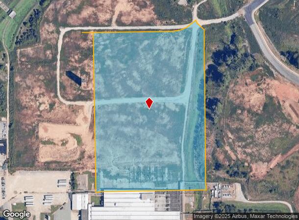
Property Record
264 Enka Heritage Pkwy, Asheville, NC 28715
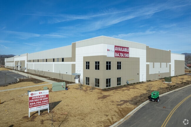
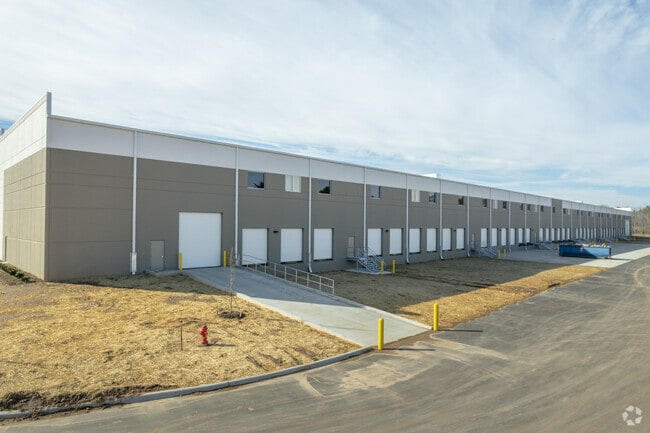

Current Lease Availabilities
NEARBY LISTINGS FOR SALE OR LEASE
Property Detail
264 Enka Heritage Pkwy
Asheville, NC
Enka Ptnrs-Fletcher-Colbond,Enka Wt
9617-43-4110-00000
LOT: PROPOSED TRACT 2 PLAT: 0237-0111
Industrialgeneral
Buncombe
AE
North Carolina
3700961700J
b
0
17.05 AC
2025
West Asheville
002306
Asheville
DEMOGRAPHICS near 264 Enka Heritage Pkwy
1 Mile
3 Mile
5 Mile
2024 Total Population
3,849
26,981
62,607
2029 Population
4,034
27,970
64,746
Pop Growth 2024-2029
+ 4.81%
+ 3.67%
+ 3.42%
Average Age
42
41
40
2024 Total Households
1,612
11,339
26,440
HH Growth 2024-2029
+ 4.34%
+ 3.13%
+ 2.87%
Median Household Inc
$69,445
$66,067
$63,931
Avg Household Size
2.30
2.30
2.30
2024 Avg HH Vehicles
2.00
2.00
2.00
Median Home Value
$337,433
$305,656
$306,508
Median Year Built
1996
1989
1986
Nearby Places
- Restaurants
- Banks
- Shops
- Fitness
- Groceries
PUBLIC TRANSPORTATION
AIRPORT
Asheville Regional
DRIVE
WALK
Distance
Asheville Regional
19 min
11.7 mi
Freight Ports
North Charleston Terminal
DRIVE
WALK
Distance
North Charleston Terminal
290 min
255.4 mi
Nearby Properties
Address
Land Use
TOTAL SIZE
Lot Size
Zoning
Address
Land Use
TOTAL SIZE
Lot Size
Zoning
251,071 SF
280.42 AC
INST
Address
Land Use
TOTAL SIZE
Lot Size
Zoning
398,787 SF
45.56 AC
RB
Address
Land Use
TOTAL SIZE
Lot Size
Zoning
100,712 SF
24.65 AC
CS
Address
Land Use
TOTAL SIZE
Lot Size
Zoning
98,232 SF
23.24 AC
EMP
Address
Land Use
TOTAL SIZE
Lot Size
Zoning
104,138 SF
33.25 AC
R-2
Address
Land Use
TOTAL SIZE
Lot Size
Zoning
85,997 SF
29.25 AC
R-3
Address
Land Use
TOTAL SIZE
Lot Size
Zoning
50,672 SF
21.21 AC
R-2
Address
Land Use
TOTAL SIZE
Lot Size
Zoning
88,817 SF
19.63 AC
R-2
Address
Land Use
TOTAL SIZE
Lot Size
Zoning
81,621 SF
19.62 AC
PS
Address
Land Use
TOTAL SIZE
Lot Size
Zoning
134,180 SF
60.94 AC
PS
Address
Land Use
TOTAL SIZE
Lot Size
Zoning
151,884 SF
129.72 AC
PS
Address
Land Use
TOTAL SIZE
Lot Size
Zoning
111,000 SF
21.97 AC
PS
Address
Land Use
TOTAL SIZE
Lot Size
Zoning
94,565 SF
25.18 AC
EMP
Address
Land Use
TOTAL SIZE
Lot Size
Zoning
126,508 SF
14.90 AC
EMP
Address
Land Use
TOTAL SIZE
Lot Size
Zoning
52,316 SF
13.68 AC
INST
Address
Land Use
TOTAL SIZE
Lot Size
Zoning
145,519 SF
10.75 AC
R-2
Address
Land Use
TOTAL SIZE
Lot Size
Zoning
79,908 SF
60 AC
PS
Address
Land Use
TOTAL SIZE
Lot Size
Zoning
131,946 SF
13.28 AC
EMP
Address
Land Use
TOTAL SIZE
Lot Size
Zoning
35,952 SF
9.30 AC
RM16
Address
Land Use
TOTAL SIZE
Lot Size
Zoning
145,468 SF
24.91 AC
COM EXP
Address
Land Use
TOTAL SIZE
Lot Size
Zoning
75,988 SF
12.90 AC
PS
Address
Land Use
TOTAL SIZE
Lot Size
Zoning
141,577 SF
30.05 AC
Address
Land Use
TOTAL SIZE
Lot Size
Zoning
13,347 SF
2.50 AC
RB
Address
Land Use
TOTAL SIZE
Lot Size
Zoning
70,824 SF
12 AC
INST
Address
Land Use
TOTAL SIZE
Lot Size
Zoning
106,000 SF
10.91 AC
HB
Address
Land Use
TOTAL SIZE
Lot Size
Zoning
13,232 SF
2.05 AC
CBII
Address
Land Use
TOTAL SIZE
Lot Size
Zoning
39,368 SF
7.77 AC
R-2
Address
Land Use
TOTAL SIZE
Lot Size
Zoning
196,498 SF
14.61 AC
EMP
Address
Land Use
TOTAL SIZE
Lot Size
Zoning
72,426 SF
11.87 AC
RM16
Address
Land Use
TOTAL SIZE
Lot Size
Zoning
23,727 SF
1.68 AC
RB
The World's #1 Commercial Real Estate Marketplace
Connect with us
© 2025 CoStar Group
The information above has been obtained from sources believed reliable. While we do not doubt its accuracy we have not verified it and make no guarantee, warranty or representation about it. It is your responsibility to independently confirm its accuracy and completeness. Any projections, opinions, assumptions, or estimates used are for example only and do not represent the current or future performance of the property. The value of this transaction to you depends on tax and other factors which should be evaluated by your tax, financial, and legal advisors. You and your advisors should conduct a careful, independent investigation of the property to determine to your satisfaction the suitability of the property for your needs.