Property Record
261 S Main St, Cattaraugus, NY 14719

NEARBY LISTINGS FOR SALE OR LEASE
-
-
View all Cattaraugus listings for sale on LoopNet.com
Property Detail
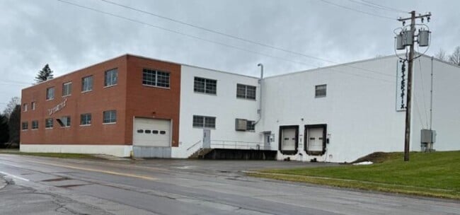
261 S Main St
Olean, NY
22 04 08 FF 218.17' MAIN FF 228.84' RUMSEY
046401-044-033-0001-010-000-0000
Cattaraugus
Manufacturinglight
New York
2025
10.000
2024
3.50 AC
960500
New York West Area
59,632 SF
Other Market Areas
DEMOGRAPHICS near 261 S Main St
1 Mile
3 Mile
5 Mile
2024 Total Population
1,009
1,751
3,017
2029 Population
1,003
1,739
2,988
Pop Growth 2024-2029
(0.59%)
(0.69%)
(0.96%)
Average Age
41
41
42
2024 Total Households
394
683
1,169
HH Growth 2024-2029
(0.76%)
(0.73%)
(0.86%)
Median Household Inc
$59,363
$58,888
$58,169
Avg Household Size
2.50
2.40
2.40
2024 Avg HH Vehicles
2.00
2.00
2.00
Median Home Value
$77,805
$83,078
$90,520
Median Year Built
1947
1948
1960
Nearby Places
Map Layers
Map Styles
 Street
 Aerial
- Restaurants
- Banks
- Shops
- Fitness
- Groceries
SALE & LEASE HISTORY
LISTING DATE
SALE/LEASE

Aug 09, 2024
For Sale
Nearby Properties
Address
Land Use
TOTAL SIZE
Lot Size
Zoning
Address
Land Use
TOTAL SIZE
Lot Size
Zoning
123,400 SF
35.10 AC
R1
Address
Land Use
TOTAL SIZE
Lot Size
Zoning
34,986 SF
19.18 AC
02 - SINGL
Address
Land Use
TOTAL SIZE
Lot Size
Zoning
0.01 AC
01 - NOT Z
Address
Land Use
TOTAL SIZE
Lot Size
Zoning
Address
Land Use
TOTAL SIZE
Lot Size
Zoning
100 AC
01 - NOT Z
Address
Land Use
TOTAL SIZE
Lot Size
Zoning
9,100 SF
1.60 AC
B2
Address
Land Use
TOTAL SIZE
Lot Size
Zoning
44,640 SF
0.64 AC
B2
Address
Land Use
TOTAL SIZE
Lot Size
Zoning
Address
Land Use
TOTAL SIZE
Lot Size
Zoning
2,592 SF
0.72 AC
R1
Address
Land Use
TOTAL SIZE
Lot Size
Zoning
7,208 SF
3.10 AC
Address
Land Use
TOTAL SIZE
Lot Size
Zoning
Address
Land Use
TOTAL SIZE
Lot Size
Zoning
6,141 SF
0.90 AC
B2
Address
Land Use
TOTAL SIZE
Lot Size
Zoning
53,200 SF
1.95 AC
R1
Address
Land Use
TOTAL SIZE
Lot Size
Zoning
0.80 AC
02 - SINGL
Address
Land Use
TOTAL SIZE
Lot Size
Zoning
1,678 SF
182.76 AC
01 - NOT Z
Address
Land Use
TOTAL SIZE
Lot Size
Zoning
Address
Land Use
TOTAL SIZE
Lot Size
Zoning
3,856 SF
10.90 AC
R1
Address
Land Use
TOTAL SIZE
Lot Size
Zoning
259.30 AC
02 - SINGL
Address
Land Use
TOTAL SIZE
Lot Size
Zoning
2,435 SF
102.24 AC
AF
Address
Land Use
TOTAL SIZE
Lot Size
Zoning
2,520 SF
0.17 AC
B1
Address
Land Use
TOTAL SIZE
Lot Size
Zoning
552 SF
309.94 AC
AF
Address
Land Use
TOTAL SIZE
Lot Size
Zoning
0.27 AC
R1
Address
Land Use
TOTAL SIZE
Lot Size
Zoning
1,738 SF
204.29 AC
AF
Address
Land Use
TOTAL SIZE
Lot Size
Zoning
Address
Land Use
TOTAL SIZE
Lot Size
Zoning
2,016 SF
88.01 AC
AF
Address
Land Use
TOTAL SIZE
Lot Size
Zoning
3,032 SF
0.42 AC
R1
Address
Land Use
TOTAL SIZE
Lot Size
Zoning
3,500 SF
1.12 AC
R1
Address
Land Use
TOTAL SIZE
Lot Size
Zoning
257.50 AC
AF
Address
Land Use
TOTAL SIZE
Lot Size
Zoning
2,520 SF
30.85 AC
2
The World's #1 Commercial Real Estate Marketplace
Connect with us
© 2026 CoStar Group
The information above has been obtained from sources believed reliable. While we do not doubt its accuracy we have not verified it and make no guarantee, warranty or representation about it. It is your responsibility to independently confirm its accuracy and completeness. Any projections, opinions, assumptions, or estimates used are for example only and do not represent the current or future performance of the property. The value of this transaction to you depends on tax and other factors which should be evaluated by your tax, financial, and legal advisors. You and your advisors should conduct a careful, independent investigation of the property to determine to your satisfaction the suitability of the property for your needs.