Property Record
261 State Highway 160, Warrior, AL 35180
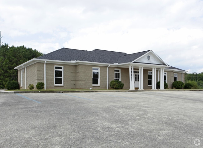

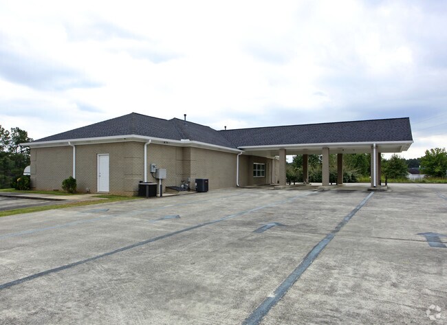
Property Detail
261 State Highway 160
26-01-02-0-000-039.002
COM INT N R/W HWY 160 & SE R/W HWY 31 E 340 S 80 TO POB CONT SW 1000 SE 234 NE 280 NW 118 W 215 TO POB-- (HAYDEN BRANCH)
Officebuilding
BLOUNT
B and X Area of moderate flood hazard, usually the area between the limits of the 100-year and 500-year floods.
Alabama
2025
1.37 AC
2025
Blount County
050604
Birmingham
2,820 SF
Birmingham, AL
NEARBY LISTINGS FOR SALE OR LEASE
-
-
View all Warrior listings for sale on LoopNet.com
DEMOGRAPHICS near 261 State Highway 160
1 mile
3 mile
5 mile
2025 Total Population
479
6,308
16,305
2030 Population
483
6,363
16,501
Pop Growth 2025-2030
+ 0.84%
+ 0.87%
+ 1.20%
Average Age
42
41
40
2025 Total Households
175
2,398
6,181
HH Growth 2025-2030
+ 1.14%
+ 0.88%
+ 1.20%
Median Household Inc
$83,928
$73,286
$76,185
Avg Household Size
2.70
2.60
2.60
2025 Avg HH Vehicles
3.00
2.00
2.00
Median Home Value
$234,482
$218,541
$225,391
Median Year Built
1990
1990
1992
Nearby Places
Map Layers
Map Styles
 Street
 Aerial
Layers
 Traffic
 Biking
Places
Listings with unknown addresses are not visible on the map
- Restaurants
- Banks
- Shops
- Fitness
- Groceries
PUBLIC TRANSPORTATION
AIRPORT
Birmingham-Shuttlesworth International
Drive
Walk
Distance
Birmingham-Shuttlesworth International
37 min
30.4 mi
Nearby Properties
Address
Land Use
TOTAL SIZE
Lot Size
Zoning
Address
Land Use
TOTAL SIZE
Lot Size
Zoning
27,903 SF
13 AC
Address
Land Use
TOTAL SIZE
Lot Size
Zoning
13,988 SF
2 AC
B
Address
Land Use
TOTAL SIZE
Lot Size
Zoning
4,652 SF
1.70 AC
Address
Land Use
TOTAL SIZE
Lot Size
Zoning
6,296 SF
2.10 AC
Address
Land Use
TOTAL SIZE
Lot Size
Zoning
6,460 SF
5.20 AC
Address
Land Use
TOTAL SIZE
Lot Size
Zoning
4,000 SF
2.70 AC
Address
Land Use
TOTAL SIZE
Lot Size
Zoning
3,000 SF
3 AC
Address
Land Use
TOTAL SIZE
Lot Size
Zoning
6,863 SF
1 AC
C1-A
Address
Land Use
TOTAL SIZE
Lot Size
Zoning
7,105 SF
1.70 AC
Address
Land Use
TOTAL SIZE
Lot Size
Zoning
5,100 SF
1 AC
B
Address
Land Use
TOTAL SIZE
Lot Size
Zoning
44,410 SF
6.60 AC
Address
Land Use
TOTAL SIZE
Lot Size
Zoning
10,000 SF
1 AC
C1
Address
Land Use
TOTAL SIZE
Lot Size
Zoning
6,061 SF
3.35 AC
Address
Land Use
TOTAL SIZE
Lot Size
Zoning
32,400 SF
3.20 AC
Address
Land Use
TOTAL SIZE
Lot Size
Zoning
23,306 SF
2 AC
B2
Address
Land Use
TOTAL SIZE
Lot Size
Zoning
24,000 SF
2 AC
Address
Land Use
TOTAL SIZE
Lot Size
Zoning
3,682 SF
7.30 AC
Address
Land Use
TOTAL SIZE
Lot Size
Zoning
1,401 SF
1 AC
C1 A
Address
Land Use
TOTAL SIZE
Lot Size
Zoning
10,000 SF
8.20 AC
Address
Land Use
TOTAL SIZE
Lot Size
Zoning
3,437 SF
1 AC
R1&B
Address
Land Use
TOTAL SIZE
Lot Size
Zoning
9,106 SF
1 AC
B1
Address
Land Use
TOTAL SIZE
Lot Size
Zoning
2,400 SF
1.03 AC
Address
Land Use
TOTAL SIZE
Lot Size
Zoning
8,200 SF
1.50 AC
Address
Land Use
TOTAL SIZE
Lot Size
Zoning
5,822 SF
0.71 AC
R3
Address
Land Use
TOTAL SIZE
Lot Size
Zoning
11,400 SF
1.70 AC
Address
Land Use
TOTAL SIZE
Lot Size
Zoning
4.30 AC
B
Address
Land Use
TOTAL SIZE
Lot Size
Zoning
10,400 SF
8.60 AC
Address
Land Use
TOTAL SIZE
Lot Size
Zoning
11,111 SF
1 AC
R2
Address
Land Use
TOTAL SIZE
Lot Size
Zoning
2,397 SF
1.46 AC
C1-A
Address
Land Use
TOTAL SIZE
Lot Size
Zoning
3,500 SF
2.60 AC
The World's #1 Commercial Real Estate Marketplace
Connect with us
© 2026 CoStar Group
The information above has been obtained from sources believed reliable. While we do not doubt its accuracy we have not verified it and make no guarantee, warranty or representation about it. It is your responsibility to independently confirm its accuracy and completeness. Any projections, opinions, assumptions, or estimates used are for example only and do not represent the current or future performance of the property. The value of this transaction to you depends on tax and other factors which should be evaluated by your tax, financial, and legal advisors. You and your advisors should conduct a careful, independent investigation of the property to determine to your satisfaction the suitability of the property for your needs.