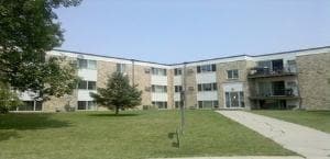
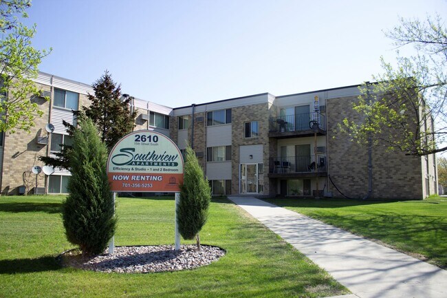
Property Record
2610 15Th St S, Fargo, ND 58103
NEARBY LISTINGS FOR SALE OR LEASE
Property Detail
2610 15Th St S
Fargo, ND-MN
Arrowhead Estates
01-0066-00070-000
LOT: 7 BLOCK: 1 ADDITION: ARROWHEAD ESTATES ADDITIONAL: ARROWHEAD ESTATES LOT 7 BLK 1
Realpropertynec
Cass
X
North Dakota
38017C0783G
7
2024
1.20 AC
2024
South Fargo
001004
Other Market Areas
28,028 SF
DEMOGRAPHICS near 2610 15Th St S
1 Mile
3 Mile
5 Mile
2024 Total Population
13,736
94,807
192,460
2029 Population
14,658
100,507
204,153
Pop Growth 2024-2029
+ 6.71%
+ 6.01%
+ 6.08%
Average Age
41
38
36
2024 Total Households
6,520
42,363
81,213
HH Growth 2024-2029
+ 7.01%
+ 6.54%
+ 6.75%
Median Household Inc
$55,900
$56,244
$62,197
Avg Household Size
2.00
2.10
2.20
2024 Avg HH Vehicles
2.00
2.00
2.00
Median Home Value
$231,570
$239,030
$249,069
Median Year Built
1980
1985
1991
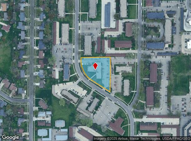
Nearby Places
Map Layers
Map Styles
 Street
 Aerial
- Restaurants
- Banks
- Shops
- Fitness
- Groceries
Nearby Properties
Address
Land Use
TOTAL SIZE
Lot Size
Zoning
Address
Land Use
TOTAL SIZE
Lot Size
Zoning
40.49 AC
Address
Land Use
TOTAL SIZE
Lot Size
Zoning
30.61 AC
Address
Land Use
TOTAL SIZE
Lot Size
Zoning
21.81 AC
Address
Land Use
TOTAL SIZE
Lot Size
Zoning
53.42 AC
Address
Land Use
TOTAL SIZE
Lot Size
Zoning
39.01 AC
Address
Land Use
TOTAL SIZE
Lot Size
Zoning
161,184 SF
10.51 AC
GC
Address
Land Use
TOTAL SIZE
Lot Size
Zoning
408,617 SF
9.33 AC
GC
Address
Land Use
TOTAL SIZE
Lot Size
Zoning
24.60 AC
Address
Land Use
TOTAL SIZE
Lot Size
Zoning
55.68 AC
Address
Land Use
TOTAL SIZE
Lot Size
Zoning
121,584 SF
5.64 AC
MR3
Address
Land Use
TOTAL SIZE
Lot Size
Zoning
162,875 SF
12.32 AC
MR3
Address
Land Use
TOTAL SIZE
Lot Size
Zoning
3.39 AC
Address
Land Use
TOTAL SIZE
Lot Size
Zoning
Address
Land Use
TOTAL SIZE
Lot Size
Zoning
2.77 AC
Address
Land Use
TOTAL SIZE
Lot Size
Zoning
7.82 AC
Address
Land Use
TOTAL SIZE
Lot Size
Zoning
0.22 AC
Address
Land Use
TOTAL SIZE
Lot Size
Zoning
999.99 AC
Address
Land Use
TOTAL SIZE
Lot Size
Zoning
0.17 AC
Address
Land Use
TOTAL SIZE
Lot Size
Zoning
4.90 AC
Address
Land Use
TOTAL SIZE
Lot Size
Zoning
2.91 AC
Address
Land Use
TOTAL SIZE
Lot Size
Zoning
163,398 SF
1.92 AC
LC
Address
Land Use
TOTAL SIZE
Lot Size
Zoning
Address
Land Use
TOTAL SIZE
Lot Size
Zoning
131,309 SF
6.62 AC
GC
Address
Land Use
TOTAL SIZE
Lot Size
Zoning
64,653 SF
2.20 AC
MR3
Address
Land Use
TOTAL SIZE
Lot Size
Zoning
6.02 AC
Address
Land Use
TOTAL SIZE
Lot Size
Zoning
45.33 AC
GC
Address
Land Use
TOTAL SIZE
Lot Size
Zoning
2.07 AC
Address
Land Use
TOTAL SIZE
Lot Size
Zoning
26,909 SF
11.65 AC
LC
Address
Land Use
TOTAL SIZE
Lot Size
Zoning
Address
Land Use
TOTAL SIZE
Lot Size
Zoning
217,776 SF
31.82 AC
GC
The World's #1 Commercial Real Estate Marketplace
Connect with us
© 2025 CoStar Group
The information above has been obtained from sources believed reliable. While we do not doubt its accuracy we have not verified it and make no guarantee, warranty or representation about it. It is your responsibility to independently confirm its accuracy and completeness. Any projections, opinions, assumptions, or estimates used are for example only and do not represent the current or future performance of the property. The value of this transaction to you depends on tax and other factors which should be evaluated by your tax, financial, and legal advisors. You and your advisors should conduct a careful, independent investigation of the property to determine to your satisfaction the suitability of the property for your needs.